Sioux County, Nebraska facts for kids
Quick facts for kids
Sioux County
|
|
|---|---|

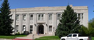
Sioux County Courthouse in Harrison
|
|

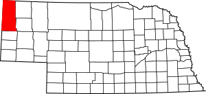
Location within the U.S. state of Nebraska
|
|
 Nebraska's location within the U.S. |
|
| Country | |
| State | |
| Founded | 1877 |
| Named for | Sioux people |
| Seat | Harrison |
| Largest village | Harrison |
| Area | |
| • Total | 2,067 sq mi (5,350 km2) |
| • Land | 2,067 sq mi (5,350 km2) |
| • Water | 0.7 sq mi (2 km2) 0.03%% |
| Population
(2020)
|
|
| • Total | 1,135 |
| • Estimate
(2022)
|
1,127 |
| • Density | 0.5491/sq mi (0.21201/km2) |
| Time zone | UTC−7 (Mountain) |
| • Summer (DST) | UTC−6 (MDT) |
| Congressional district | 3rd |
Sioux County is a county located in the northwest part of Nebraska, a state in the United States. It was created in 1877. As of 2020, about 1,135 people live there. The main town and county seat is Harrison.
Sioux County is part of the Scottsbluff area, which is a group of nearby towns and counties. When Nebraska first started its license plate system in 1922, Sioux County was given the number 80. This was because it had the 80th largest number of vehicles registered in the state at that time.
Contents
Where is Sioux County? (Geography)
Sioux County is in the very northwest corner of Nebraska. To the north, it shares a border with South Dakota. To the west, it borders Wyoming.
The Niobrara River flows through the upper middle part of the county, heading southeast and then east. The land here has low, rolling hills and is quite dry. It slopes gently towards the east and southeast. Farmers use some of the land for growing crops, sometimes with special watering systems called center pivot irrigation.
The county covers about 2,067 square miles (5,353 square kilometers). Almost all of this area is land, with only a tiny bit (0.03%) being water.
Main Roads in Sioux County
 US 20
US 20 N-2
N-2 N-29
N-29 N-71
N-71
Special Protected Areas
Sioux County is home to several important natural and historical sites:
- Agate Fossil Beds National Monument: A place with many ancient animal fossils.
- Fort Robinson State Park: A large park with history and outdoor activities.
- Gilbert-Baker Wildlife Area: A protected area for wildlife.
- Nebraska National Forest (part): A section of a large forest.
- Peterson State Wildlife Area: Another area for wildlife.
- Soldier Creek Wilderness: A wild, undeveloped area within Peterson State Wildlife Area.
- Oglala National Grassland (part): A section of a vast grassland.
- Toadstool Geologic Park: Known for its unique rock formations.
- Hudson-Meng Bison Kill: An archaeological site where many bison bones were found.
Neighboring Counties
Sioux County shares its borders with these other counties:
- Fall River County, South Dakota – to the north
- Dawes County – to the northeast
- Box Butte County – to the southeast
- Scotts Bluff County - to the south
- Goshen County, Wyoming - to the southwest
- Niobrara County, Wyoming - to the northwest
Who Lives in Sioux County? (Demographics)
| Historical population | |||
|---|---|---|---|
| Census | Pop. | %± | |
| 1880 | 699 | — | |
| 1890 | 2,452 | 250.8% | |
| 1900 | 2,055 | −16.2% | |
| 1910 | 5,599 | 172.5% | |
| 1920 | 4,528 | −19.1% | |
| 1930 | 4,667 | 3.1% | |
| 1940 | 4,001 | −14.3% | |
| 1950 | 3,124 | −21.9% | |
| 1960 | 2,575 | −17.6% | |
| 1970 | 2,034 | −21.0% | |
| 1980 | 1,845 | −9.3% | |
| 1990 | 1,549 | −16.0% | |
| 2000 | 1,475 | −4.8% | |
| 2010 | 1,311 | −11.1% | |
| 2020 | 1,135 | −13.4% | |
| 2022 (est.) | 1,127 | −14.0% | |
| US Decennial Census 1790-1960 1900-1990 1990-2000 2010 2020 2022 |
|||
According to the 2020 United States Census, there were 1,135 people living in Sioux County. There were 450 households, which are groups of people living together in one home. The county has about 0.56 people per square mile.
Most of the people in the county (about 95.2%) are White. About 1.5% are Native American, and 0.4% are Asian. About 2.4% of the people belong to two or more groups. Also, about 6.1% of the population is of Hispanic or Latino background.
When looking at age groups, about 21% of the people are under 18 years old. About 47.3% are between 18 and 64 years old. And about 31.7% are 65 years old or older. Slightly less than half of the population (46.7%) are female.
In 2022, the average income for a household in the county was $50,833 per year. The average income per person was $26,748. About 16.1% of the people in the county live below the poverty line, meaning they have a lower income.
Towns and Communities
Sioux County has one main town and several smaller communities.
Towns
- Harrison (This is the county seat, meaning it's the center for county government.)
Unincorporated Communities
These are smaller places that don't have their own local government:
Ghost Towns
These are places where people used to live, but now they are mostly empty:
See also
 In Spanish: Condado de Sioux (Nebraska) para niños
 | Madam C. J. Walker |
 | Janet Emerson Bashen |
 | Annie Turnbo Malone |
 | Maggie L. Walker |

