Dawes County, Nebraska facts for kids
Quick facts for kids
Dawes County
|
|
|---|---|

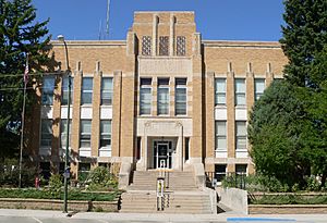
Dawes County Courthouse in Chadron
|
|

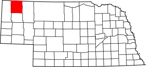
Location within the U.S. state of Nebraska
|
|
 Nebraska's location within the U.S. |
|
| Country | |
| State | |
| Founded | February 19, 1885 |
| Named for | James W. Dawes |
| Seat | Chadron |
| Largest city | Chadron |
| Area | |
| • Total | 1,401 sq mi (3,630 km2) |
| • Land | 1,396 sq mi (3,620 km2) |
| • Water | 4.6 sq mi (12 km2) 0.3%% |
| Population
(2020)
|
|
| • Total | 8,199 |
| • Density | 5.8522/sq mi (2.2596/km2) |
| Time zone | UTC−7 (Mountain) |
| • Summer (DST) | UTC−6 (MDT) |
| Congressional district | 3rd |
Dawes County is a county located in the western part of Nebraska, a U.S. state. In 2020, about 8,199 people lived here. The main town and county seat (where the county government is) is Chadron.
The county was created in 1885. It was named after James W. Dawes, who was the Governor of Nebraska at that time.
If you see a Nebraska license plate from Dawes County, it will start with the number 69. This is because when Nebraska first started its license plate system in 1922, Dawes County had the 69th largest number of vehicles registered.
Contents
History of Dawes County
Before 1885, the area that is now Dawes County was not officially organized. It was part of a larger, unorganized region in northwestern Nebraska.
On February 19, 1877, this area became part of Sioux County. Then, on February 19, 1885, Dawes County was officially separated from Sioux County and given its own name.
Geography of Dawes County
Dawes County is located along the northern border of Nebraska. Its northern edge touches the southern border of South Dakota.
The US Census Bureau says the county covers a total area of about 1,401 square miles. Most of this (about 1,396 square miles) is land, and a small part (about 4.6 square miles) is water.
Because Dawes County is in western Nebraska, people there follow Mountain Time. The eastern two-thirds of Nebraska uses Central Time.
Main Roads
Here are the major highways that go through Dawes County:
Local Transportation
- Chadron City Transit provides public transportation in Chadron.
Neighboring Counties
Dawes County shares borders with these other counties:
- Oglala Lakota County, South Dakota - to the northeast
- Sheridan County - to the east
- Box Butte County - to the south
- Sioux County - to the west
- Fall River County, South Dakota - to the northwest
National Parks and Forests
Parts of these protected areas are in Dawes County:
- Nebraska National Forest
- Pine Ridge National Recreation Area
- Oglala National Grassland
State Parks and Recreation Areas
You can find these state-protected areas in Dawes County:
- Box Butte Reservoir State Recreation Area
- Chadron State Park
- Fort Robinson State Park (part)
- Chadron Creek Ranch State Wildlife Management Area
- Bordeaux State Wildlife Management Area
- Bighorn State Wildlife Management Area
- Ponderosa State Wildlife Management Area
People of Dawes County
| Historical population | |||
|---|---|---|---|
| Census | Pop. | %± | |
| 1890 | 9,722 | — | |
| 1900 | 6,215 | −36.1% | |
| 1910 | 8,254 | 32.8% | |
| 1920 | 10,160 | 23.1% | |
| 1930 | 11,493 | 13.1% | |
| 1940 | 10,128 | −11.9% | |
| 1950 | 9,708 | −4.1% | |
| 1960 | 9,536 | −1.8% | |
| 1970 | 9,761 | 2.4% | |
| 1980 | 9,609 | −1.6% | |
| 1990 | 9,021 | −6.1% | |
| 2000 | 9,060 | 0.4% | |
| 2010 | 9,182 | 1.3% | |
| 2020 | 8,199 | −10.7% | |
| 2022 (est.) | 8,241 | −10.2% | |
| US Decennial Census 1790-1960 1900-1990 1990-2000 2010 2020 |
|||
According to the 2000 United States Census, there were 9,060 people living in Dawes County. The population density was about 6 people per square mile.
The people living in the county were mostly White, with smaller groups of Native American, Black or African American, Asian, and Pacific Islander people. Some people were also from other races or from two or more races. About 2.43% of the population was Hispanic or Latino.
The median age in the county was 31 years old. This means half the people were younger than 31, and half were older.
Communities in Dawes County
Cities
Village
Unincorporated Communities
These are smaller communities that are not officially organized as cities or villages:
Ghost Town
- Belmont is a former town that is now abandoned.
 In Spanish: Condado de Dawes para niños
 | Victor J. Glover |
 | Yvonne Cagle |
 | Jeanette Epps |
 | Bernard A. Harris Jr. |

