Crawford, Nebraska facts for kids
Quick facts for kids
Crawford, Nebraska
|
|
|---|---|

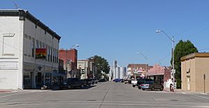
Downtown Crawford: 2nd Street, looking north from Linn Street, August 2010
|
|

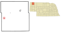
Location of Crawford, Nebraska
|
|
| Country | United States |
| State | Nebraska |
| County | Dawes |
| Area | |
| • Total | 1.17 sq mi (3.04 km2) |
| • Land | 1.17 sq mi (3.04 km2) |
| • Water | 0.00 sq mi (0.00 km2) |
| Elevation | 3,681 ft (1,122 m) |
| Population
(2020)
|
|
| • Total | 840 |
| • Density | 715.50/sq mi (276.26/km2) |
| Time zone | UTC-7 (Mountain (MST)) |
| • Summer (DST) | UTC-6 (MDT) |
| ZIP code |
69339
|
| Area code(s) | 308 |
| FIPS code | 31-11195 |
| GNIS feature ID | 2393663 |
| Website | http://www.crawfordnebraska.net/ |
Crawford is a city in Dawes County, Nebraska, United States. It is located in the Great Plains region. In 2020, about 840 people lived there.
Crawford became a town in 1886. It was named after Captain Emmet Crawford. He used to be stationed at a nearby place called Fort Robinson.
Contents
History of Crawford
How Crawford Started
In 1886, a railroad called the Fremont, Elkhorn and Missouri Valley Railroad was built towards Wyoming. It passed through land owned by William Annin, who sold his land for a new town. This new town was named after Lt. Emmet Crawford. He had been at Fort Robinson but passed away in Mexico in January 1886.
The town's first plan was officially recorded on June 21, 1886. Some people tried to make Crawford a village. They needed 200 signatures but only got 69. So, they asked soldiers at Fort Robinson to sign, and Crawford became an official town in August 1886.
Growing as a City
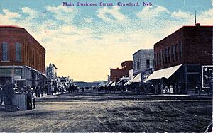
Another railroad, the Chicago, Burlington and Quincy Railroad, arrived in Crawford in 1889. This helped the town grow even more. In 1907, Crawford became a city. By 1911, it had the seventh-highest amount of business in Nebraska.
Many different businesses opened and closed over the years. These included a brick factory and a pickle factory. Crawford also wanted a state teacher's college. But the college, now Chadron State College, was built in nearby Chadron instead. This was because Crawford was so close to Fort Robinson.
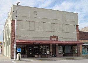
One interesting business was the Elite Theater. It opened around 1910 in an old saloon. Mrs. Georgianna Higgins owned and ran the theater. She is believed to be the first woman to own a theater in the United States.
Population Changes
Crawford's population was highest in 1910, with 2,536 people. This was partly due to the Kinkaid Act, which encouraged people to move to the area. However, the population dropped to 1,646 by 1920.
The town slowly grew again, reaching 1,845 people in 1940. Since then, the population has been slowly getting smaller.
In the Lakota language, Crawford is called oglíyotake otȟúŋwahe. This means "Return and Settle City."
Geography of Crawford
Crawford is located at 42°41′1″N 103°24′44″W / 42.68361°N 103.41222°W. The city covers about 1.18 square miles (3.04 square kilometers) of land. It is located along the White River.
Crawford is about 3,675 feet (1,120 meters) above sea level. The area around it has rolling hills and bluffs. The ground is made of sandy dirt and a type of clay called "gumbo."
People in Crawford
| Historical population | |||
|---|---|---|---|
| Census | Pop. | %± | |
| 1890 | 571 | — | |
| 1900 | 731 | 28.0% | |
| 1910 | 1,323 | 81.0% | |
| 1920 | 1,646 | 24.4% | |
| 1930 | 1,703 | 3.5% | |
| 1940 | 1,845 | 8.3% | |
| 1950 | 1,824 | −1.1% | |
| 1960 | 1,588 | −12.9% | |
| 1970 | 1,438 | −9.4% | |
| 1980 | 1,542 | 7.2% | |
| 1990 | 1,115 | −27.7% | |
| 2000 | 1,107 | −0.7% | |
| 2010 | 997 | −9.9% | |
| 2020 | 840 | −15.7% | |
| U.S. Decennial Census | |||
2010 Census Information
In 2010, there were 997 people living in Crawford. There were 470 households, which are groups of people living together. About 21.5% of these households had children under 18.
The average age of people in Crawford was 49.1 years old. About 21% of the people were under 18. Also, 27.5% of the people were 65 years old or older. There were more females (55%) than males (45%) in the city.
Arts and Culture
Crawford and the area around it have several interesting cultural places. The main library is the Crawford Public Library. The Crawford Historical Museum has old items and information about the city's past.
Fort Robinson is a state park and a special historical place. It is a few miles west of Crawford. The park has two museums and a play theatre. South of Crawford, you can find the Belmont Tunnel. Also, two buildings in Crawford are listed on the National Register of Historic Places: the Co-operative Block Building and the US Post Office.
Yearly Events
Crawford hosts several fun events each year:
- The Peabody Hale Fiddle Contest.
- The Old West Trail PRCA Rodeo.
- The Northwest Nebraska Rock Swap.
- Many activities for Independence Day.
- The Fort Robinson Western & Wildlife Art Show.
Parks and Recreation
Crawford has a city park in the northwest part of town, along the White River. Another park, Peabody Hale Memorial Park, has the city's swimming pool and baseball fields.
Fort Robinson State Park and the Nebraska National Forest are also great places for outdoor activities. Crawford also has a golf course called Legends Buttes Golf Course. West of the city park are the rodeo grounds, where a yearly rodeo is held.
Rail Transportation
Crawford is served by two freight railroads: BNSF Railway and the Nebraska Northwestern Railroad. The original railroad line west of Crawford was removed in 1992.
There are no passenger trains to or from Crawford anymore. The old train station was taken down a long time ago. However, Crawford is still an important spot for the railroad. BNSF Railway still has teams of engineers based in Crawford. They help push trains up the steep Crawford Hill.
Notable People
- Kermit Brashear: A former speaker of the Nebraska Legislature, which is like the state's law-making group.
- Roger Hughes: A football coach.
- Jerry D. Mahlman: A meteorologist (weather expert) and climatologist (climate expert).
- Robert L. Wheeler: A Hall of Fame trainer of Thoroughbred racehorses.
See also
 In Spanish: Crawford (Nebraska) para niños
 | DeHart Hubbard |
 | Wilma Rudolph |
 | Jesse Owens |
 | Jackie Joyner-Kersee |
 | Major Taylor |


