
White River (Missouri River tributary) facts for kids
Quick facts for kids White River |
|
|---|---|

White River at the U.S. Highway 20 crossing west of Crawford in northwest Nebraska
|
|

White River watershed
|
|

Location of the mouth of the White River in South Dakota
|
|
| Country | United States |
| State | Nebraska, South Dakota |
| County | Dawes, Oglala Lakota, Pennington, Jackson, Jones, Mellette, Tripp, Lyman |
| Physical characteristics | |
| Main source | Pine Ridge near Harrison, Dawes County, Nebraska 4,861 ft (1,482 m) 42°41′10″N 103°50′14″W / 42.68611°N 103.83722°W |
| River mouth | Missouri River near Chamberlain, Lyman County, South Dakota 1,601 ft (488 m) 43°42′50″N 99°28′01″W / 43.71389°N 99.46694°W |
| Length | 580 mi (930 km) |
| Basin features | |
| Basin size | 10,200 sq mi (26,000 km2) |
The White River is a river in the United States. It flows for about 580 miles (930 km) through the states of Nebraska and South Dakota. The river gets its name from its white-gray water. This color comes from sand, clay, and volcanic ash that the river picks up from the land it flows through, especially near the Badlands. The White River drains an area of about 10,200 square miles (26,000 km2). Most of this area, about 8,500 square miles (22,000 km2), is in South Dakota. The river flows through hills, flat areas, and badlands where not many people live.
Contents
Where the White River Flows
The White River starts in northwestern Nebraska. Its source is in the Pine Ridge area, north of Harrison. It begins at a height of about 4,861 feet (1,482 m) above sea level.
From its start, the river first flows southeast, then turns northeast. It passes by Fort Robinson and flows north of Crawford. The river then crosses into southwestern South Dakota. Here, it flows north through the Pine Ridge Indian Reservation. After that, it turns northeast.
Key Places Along the River
As it flows northeast, the White River is joined by Wounded Knee Creek. It also flows between parts of Badlands National Park. The river then moves east-northeast and southeast. It forms the northern border of the reservation and the southern border of Buffalo Gap National Grassland.
The Little White River joins it about 15 miles (24 km) south of Murdo. Finally, the White River flows east to join the Missouri River in Lake Francis Case. This meeting point is about 15 miles (24 km) southwest of Chamberlain.
Water Flow and Quality
Sometimes, the White River may not have water flowing on its surface. This happens because the areas around it, like the badlands and prairies, are very dry. However, heavy thunderstorms can cause the river to flow very strongly for a short time. Near Chamberlain, the river flows all year round. In 2001, the water in the White River was generally considered to be of good quality.
Uses of the White River
The water from the White River can be used for different purposes. For example, in 2019, a company called TC Energy planned to use water from the White River. This water was needed for building parts of the Keystone pipeline. It was also used for building camps to house the workers.
Images for kids
-
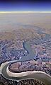
An aerial view of the Missouri River where the smaller White River flows into it. The Interstate 90 bridge can be seen in the distance.

See also
 In Spanish: Río White (Dakota del Sur) para niños
