Jones County, South Dakota facts for kids
Quick facts for kids
Jones County
|
|
|---|---|

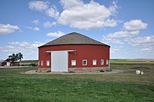
Freier Round Barn
|
|

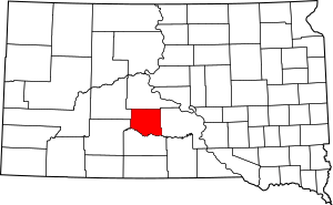
Location within the U.S. state of South Dakota
|
|
 South Dakota's location within the U.S. |
|
| Country | |
| State | |
| Founded | 1916 (created) January 15, 1917 (organized) |
| Named for | George Wallace Jones |
| Seat | Murdo |
| Largest city | Murdo |
| Area | |
| • Total | 971 sq mi (2,510 km2) |
| • Land | 970 sq mi (2,500 km2) |
| • Water | 1.2 sq mi (3 km2) 0.1% |
| Population
(2020)
|
|
| • Total | 917 |
| • Estimate
(2023)
|
855 |
| • Density | 0.9444/sq mi (0.3646/km2) |
| Time zone | UTC−6 (Central) |
| • Summer (DST) | UTC−5 (CDT) |
| Congressional district | At-large |
Jones County is a county located in the state of South Dakota. A county is like a smaller region within a state. As of the 2020 census, about 917 people lived here. This makes it the county with the fewest people in South Dakota.
The main town, or county seat, is Murdo. Jones County was created in 1916 and officially started in 1917. It is the newest county in South Dakota. The county was named after Granville Whittington Jones. He was a clergyman and lawyer from Arkansas who moved to South Dakota.
Exploring Jones County's Land
The land in Jones County has rolling hills and is quite dry. Some areas are used for farming. The Bad River flows through the northwest part of the county. The White River forms the southern border.
The southern parts of the county have many small valleys and streams. These flow towards the White River. The land generally slopes down towards the northeast. The highest point is about 2,444 feet (745 meters) above sea level. The county covers a total area of 971 square miles (2,515 square kilometers). Most of this is land, with only a small amount of water.
Time Zones in South Dakota
South Dakota has two different time zones. The eastern part of the state uses Central Time. The western part uses Mountain Time. Jones County is one of the counties that observes Central Time.
Main Roads and Highways
Two important highways pass through Jones County:
Neighboring Counties
Jones County shares borders with several other counties:
- Stanley County - to the north
- Lyman County - to the east
- Mellette County - to the south
- Jackson County - to the southwest (this county uses Mountain Time)
- Haakon County - to the northwest (this county also uses Mountain Time)
Protected Natural Areas
Jones County is home to some protected areas:
- Buxcel State Game Production Area
- Part of the Fort Pierre National Grassland
Lakes and Reservoirs
- Sheriff Reservoir
People of Jones County
| Historical population | |||
|---|---|---|---|
| Census | Pop. | %± | |
| 1920 | 3,004 | — | |
| 1930 | 3,177 | 5.8% | |
| 1940 | 2,509 | −21.0% | |
| 1950 | 2,281 | −9.1% | |
| 1960 | 2,066 | −9.4% | |
| 1970 | 1,882 | −8.9% | |
| 1980 | 1,463 | −22.3% | |
| 1990 | 1,324 | −9.5% | |
| 2000 | 1,193 | −9.9% | |
| 2010 | 1,006 | −15.7% | |
| 2020 | 917 | −8.8% | |
| 2023 (est.) | 855 | −15.0% | |
| U.S. Decennial Census 1790-1960 1900-1990 1990-2000 2010-2020 |
|||
The population of Jones County has changed over the years. The numbers above show how many people lived there during different census counts.
What the 2020 Census Shows
In 2020, there were 917 people living in Jones County. There were 399 households and 245 families. The population density was about 0.9 people per square mile. This means there aren't many people living in a large area. There were also 504 housing units in the county.
What the 2010 Census Showed
In 2010, there were 1,006 people living in the county. The population density was about 1.0 person per square mile. Most people in the county were white (95.6%). About 2.0% were American Indian. People from two or more races made up 1.9%. About 1.3% of the population was of Hispanic or Latino origin.
Many people in Jones County have ancestors from Europe. In 2010, the largest ancestry groups were German, Irish, and Norwegian.
Towns and Communities
Jones County has several towns and communities:
City
- Murdo (This is the county seat)
Town
Census-designated place
Unincorporated community
Townships
Townships are small local government areas. Jones County has these townships:
- Buffalo
- Draper
- Dunkel
- Grandview
- Kolls
- Morga
- Mullen
- Mussman
- Okaton
- Scovil
- South Creek
- Williams Creek
- Zickrick
Unorganized territories
These are areas that do not have their own local government.
- Central Jones
- North Jones
- Rich Valley
- Westover
See also
 In Spanish: Condado de Jones (Dakota del Sur) para niños
 | Claudette Colvin |
 | Myrlie Evers-Williams |
 | Alberta Odell Jones |

