Stanley County, South Dakota facts for kids
Quick facts for kids
Stanley County
|
|
|---|---|

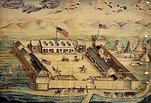
Watercolor drawing of Fort Pierre Chouteau. Dated 1854.
|
|

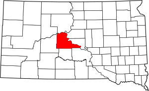
Location within the U.S. state of South Dakota
|
|
 South Dakota's location within the U.S. |
|
| Country | |
| State | |
| Founded | 1873 (created) 1890 (organized) |
| Named for | David S. Stanley |
| Seat | Fort Pierre |
| Largest city | Fort Pierre |
| Area | |
| • Total | 1,517 sq mi (3,930 km2) |
| • Land | 1,444 sq mi (3,740 km2) |
| • Water | 73 sq mi (190 km2) 4.8% |
| Population
(2020)
|
|
| • Total | 2,980 |
| • Estimate
(2023)
|
3,043 |
| • Density | 1.964/sq mi (0.7585/km2) |
| Time zones | |
| western portion | UTC−7 (Mountain) |
| • Summer (DST) | UTC−6 (MDT) |
| eastern portion | UTC−6 (Central) |
| • Summer (DST) | UTC−5 (CDT) |
| Congressional district | At-large |
Stanley County is a place in the state of South Dakota in the United States. In 2020, about 2,980 people lived there. The main town and county seat is Fort Pierre.
The county was first created in 1873 and officially set up in 1890. It is named after David S. Stanley. He was a commander at a nearby fort called Fort Sully from 1866 to 1874.
Stanley County is part of the larger Pierre area, which is a group of towns connected by jobs and daily life.
Contents
Geography
Stanley County is bordered by two important rivers. The Cheyenne River forms its northwestern edge, flowing east into the Missouri River. The Missouri River then forms the county's northeast border, flowing southeast.
The land in Stanley County has rolling hills and valleys. It is a bit dry, but some areas are used for farming. The highest point in the county is in the southwest corner, about 2,198 feet (670 meters) above sea level.
The county covers a total area of about 1,517 square miles (3,929 square kilometers). Most of this is land (1,444 square miles or 3,740 square kilometers), and a smaller part is water (73 square miles or 189 square kilometers).
Time Zones
South Dakota has two time zones. Most counties in the eastern part of the state use Central Time. Counties in the western part use Mountain Time. Stanley County is special because it's on the edge of these two zones.
Even though Fort Pierre, the county seat, is officially in the Mountain Time Zone, most people there use Central Time. This is because they have strong connections with Pierre, which is just across the river and uses Central Time.
Major Roads
Neighboring Counties
Stanley County shares borders with these other counties:
- Dewey County - to the north
- Sully County - to the northeast
- Hughes County - to the east
- Lyman County - to the southeast
- Jones County - to the south
- Haakon County - to the west
- Ziebach County - to the northwest
Protected Natural Areas
Stanley County has several areas set aside to protect nature and provide outdoor fun. These include:
- Antelope Creek State Game Production Area
- Antelope Creek State Lakeside Use Area
- Brush Creek State Game Production Area
- Chantier Creek State Game Production Area
- Chantier Creek State Lakeside Use Area
- Fort George State Game Production Area
- Fort Pierre National Grassland (part)
- Foster Bay State Lakeside Use Area
- Frozen Man Creek State Game Production Area
- Hayes Lake State Game Production Area
- Minneconjou State Game Production Area
- Minneconjou State Lakeside Use Area
- Oahe Downstream State Recreation Area
- Schomer Draw State Game Production Area
- West Shore State Lakeside Use Area
Lakes
- Lake Oahe (part)
- Lake Sharpe (part)
Population Information
| Historical population | |||
|---|---|---|---|
| Census | Pop. | %± | |
| 1880 | 793 | — | |
| 1890 | 1,028 | 29.6% | |
| 1900 | 1,341 | 30.4% | |
| 1910 | 14,975 | 1,016.7% | |
| 1920 | 2,908 | −80.6% | |
| 1930 | 2,381 | −18.1% | |
| 1940 | 1,959 | −17.7% | |
| 1950 | 2,055 | 4.9% | |
| 1960 | 4,085 | 98.8% | |
| 1970 | 2,457 | −39.9% | |
| 1980 | 2,533 | 3.1% | |
| 1990 | 2,453 | −3.2% | |
| 2000 | 2,772 | 13.0% | |
| 2010 | 2,966 | 7.0% | |
| 2020 | 2,980 | 0.5% | |
| 2023 (est.) | 3,043 | 2.6% | |
| U.S. Decennial Census 1790-1960 1900-1990 1990-2000 2010-2020 |
|||
2020 Census
In 2020, there were 2,980 people living in Stanley County. There were 1,244 households, which are groups of people living together.
2010 Census
In 2010, there were 2,966 people in the county. Most people (90.0%) were white. About 6.6% were Native American. People from different backgrounds made up the rest of the population.
Most households (56.7%) were married couples living together. About 30.8% of households had children under 18. The average age of people in the county was 41.9 years old.
Communities
City
- Fort Pierre (This is the county seat, meaning it's the main town where the county government is located.)
Other Communities
These are smaller, unincorporated communities in the county:
- Hayes
- Mission Ridge
- Sansarc
- Wendte
County Divisions
Stanley County does not have smaller areas called townships. Instead, it is divided into three "unorganized territories": Lower Brule, North Stanley, and South Stanley.
Famous Person
See also
 In Spanish: Condado de Stanley (Dakota del Sur) para niños
 | Charles R. Drew |
 | Benjamin Banneker |
 | Jane C. Wright |
 | Roger Arliner Young |

