Cheyenne River facts for kids
Quick facts for kids Cheyenne River |
|
|---|---|

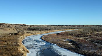
Cheyenne River at the I-90 bridge crossing, near Wasta in Pennington County.
|
|

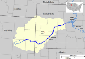
Cheyenne River course and watershed.
|
|
| Other name(s) | Lakota: Wakpá Wašté; "Good River" |
| Country | United States |
| State | Wyoming, South Dakota |
| Physical characteristics | |
| Main source | Thunder Basin National Grassland Converse County, Wyoming 43°25′33″N 105°03′30″W / 43.425928°N 105.058426°W |
| River mouth | Lake Oahe / Missouri River Ziebach County / Haakon County, South Dakota 44°43′26″N 101°10′00″W / 44.723965°N 101.166749°W |
| Length | 295 mi (475 km) |
| Basin features | |
| Basin size | 24,240 sq mi (62,800 km2) |
The Cheyenne River (called Wakpá Wašté in Lakota, meaning "Good River") is an important river in the United States. Its name comes from the Cheyenne people who once lived nearby. This river flows through the states of Wyoming and South Dakota.
The Cheyenne River is about 295 miles (475 km) long. It drains a very large area of land, about 24,240 square miles (62,800 km2). Most of this area, about 60%, is in South Dakota. The rest is mostly in Wyoming. The river eventually flows into the Missouri River.
Contents
Where the Cheyenne River Flows
The Cheyenne River starts in northeastern Wyoming. It begins where two smaller creeks, Antelope Creek and Dry Fork Creek, join together. This starting point is in the Thunder Basin National Grassland.
The river then flows east into South Dakota. It passes by the town of Edgemont. It also flows around the southern part of the Black Hills. Along its path, the river goes through Angostura Reservoir.
After leaving the Black Hills, the Cheyenne River turns northeast. It flows past Oral and the Buffalo Gap National Grassland. It also runs along the edge of the Pine Ridge Indian Reservation and Badlands National Park.
Joining Other Rivers
The Cheyenne River is joined by Rapid Creek. It then passes Wasta. A very important river, the Belle Fourche River, flows into the Cheyenne River in eastern Meade County. The Belle Fourche River is the largest river that feeds into the Cheyenne.
After this, the Cheyenne River flows east-northeast. It runs along the southern border of the Cheyenne River Indian Reservation. Near the town of Cherry Creek, another stream called Cherry Creek joins it.
Finally, the Cheyenne River flows into the Missouri River at Lake Oahe. This is about 32 miles (50 km) northwest of Pierre, South Dakota. The last 35 miles (56 km) of the Cheyenne River actually form an arm of Lake Oahe.
Water Sources and Quality
The main source of water for the Cheyenne River comes from snow melting in the Black Hills. Other important streams that feed the river include Rapid, Sulphur, Plum, Cherry, and Owl Creeks.
In the past, the river had some pollution from mining in the Black Hills. This included things like zinc and arsenic. However, new rules about water quality have greatly reduced these problems. Today, the Cheyenne River still has more dissolved minerals than other major rivers in South Dakota.
The Cheyenne River Area
The area of land drained by the Cheyenne River is called its watershed. This watershed is part of the much larger Missouri River watershed. It covers parts of northeastern Wyoming, southwestern and south-central South Dakota. Small parts of northwestern Nebraska and southeastern Montana are also included.
Most of the land in the Cheyenne watershed is grassland, about 62.8%. There are also areas of shrubland (16.3%) and forests (11.9%). The biggest towns in this area are Rapid City, South Dakota and Gillette, Wyoming.
Water Use and Future Concerns
In 2010, people in these states used a lot of water. On average, about 1,170 gallons of water were used per person each day. Over 600 million gallons of water are stored in 9 lakes and reservoirs within the Cheyenne watershed.
A big concern for the Cheyenne watershed is sedimentation. This means too much dirt and sand builds up in the river and reservoirs. This can reduce how much water the reservoirs can hold.
Another concern is how a warming climate might affect the river. Warmer temperatures could mean less water for farms and wildlife. It could also change when snow melts and flows into the river. This affects how much water is available for different uses, like making electricity from hydropower.
See also
 In Spanish: Río Cheyenne para niños
 | Claudette Colvin |
 | Myrlie Evers-Williams |
 | Alberta Odell Jones |

