
Gillette, Wyoming facts for kids
Quick facts for kids
Gillette, Wyoming
|
||
|---|---|---|
|
City
|
||

Gillette seen from Overlook Park
|
||
|
||

Location of Gillette in Campbell County, Wyoming
|
||
| Country | ||
| State | ||
| County | Campbell | |
| Government | ||
| • Type | Mayor–Council | |
| • Body | Gillette City Council | |
| Area | ||
| • Total | 23.17 sq mi (60.01 km2) | |
| • Land | 23.13 sq mi (59.91 km2) | |
| • Water | 0.04 sq mi (0.10 km2) | |
| Elevation | 4,554 ft (1,388 m) | |
| Population
(2020)
|
||
| • Total | 33,403 | |
| • Density | 1,384.66/sq mi (534.63/km2) | |
| Time zone | UTC−7 (Mountain (MST)) | |
| • Summer (DST) | UTC−6 (MDT) | |
| ZIP code |
82716-82718
|
|
| Area code(s) | 307, exchanges 670, 682, 685-688 | |
| FIPS code | 56-31855 | |
| GNIS feature ID | 1609094 | |

Gillette (/dʒɪˈlɛt/, jih-LET) is a city in Wyoming, United States. It is the main city of Campbell County, Wyoming. The town started in 1891 because of the Chicago, Burlington and Quincy Railroad.
As of July 1, 2023, about 33,496 people lived there. This makes Gillette the 3rd largest city in Wyoming. Only Cheyenne and Casper have more people. Gillette's population grew a lot after the year 2000. This was because of a boom in its local fossil fuel industries.
Gillette is in an area rich in coal, oil, and coalbed methane gas. The city calls itself the "Energy Capital of the Nation." This is because Wyoming provides nearly 35% of the nation's coal. However, less coal is being used in the U.S. now. This has caused some economic challenges for Gillette. City leaders are looking for new industries and jobs. Gillette is also a key center for media, education, health, and arts in the county.
Contents
History of Gillette
.jpg)
Before it was named Gillette, the area was known as Donkey Town. This name came from Donkey Creek. Later, it was moved and called Rocky Pile, after Rocky Draw.
Gillette was officially started in 1891. This happened when the Chicago, Burlington & Quincy Railroad arrived. The city was made official on January 6, 1892. This was less than two years after Wyoming became a state. The railroad company named the town Gillette after Edward Gillette. He was a surveyor for the company.
In November 1895, a big fire destroyed most of the city. Only a few buildings were left. Between 1895 and 1905, many families moved to Gillette. These families came from different places, including Virginia and Ireland. They brought their different traditions and beliefs with them.
In 1974, a psychologist named ElDean Kohrs studied Gillette. He used the town as an example of what he called the Gillette syndrome. This term describes social problems that can happen when a community grows very quickly. In the 1960s, Gillette's population doubled. Kohrs suggested this fast growth led to things like higher living costs. Some people have debated how much the energy industry caused these changes. Similar issues were seen in other fast-growing areas.
On January 1, 2018, Gillette grew by adding a nearby area called Antelope Valley-Crestview. This area had 1,658 people in 2010.
Geography of Gillette

Gillette is located at 44°16′58″N 105°30′19″W / 44.28278°N 105.50528°W. It sits between the Bighorn Mountains to the west and the Black Hills to the east. This area is known as the Powder River Basin.
The city covers about 19 square miles (49 square kilometers). Most of this area is land.
When Gillette was founded, there were not many trees. The native trees, like box elder and cottonwood, grew along creeks. The oldest non-native trees were planted in the 1940s. These included elm, cottonwood, and ponderosa pine. In the 1960s, more types of trees were planted. These included crab apples and honey locust. Nurseries began selling trees in the 1970s. This helped make the city's tree population more diverse.
Gillette's Skyline


Climate in Gillette
Gillette has a climate that is a mix of humid continental and cool semi-arid. This means it has hot summers with pleasant mornings. Winters are usually very cold, but the weather can change a lot.
| Climate data for Gillette 4SE, Wyoming (1991–2020 normals, extremes 1902–present) | |||||||||||||
|---|---|---|---|---|---|---|---|---|---|---|---|---|---|
| Month | Jan | Feb | Mar | Apr | May | Jun | Jul | Aug | Sep | Oct | Nov | Dec | Year |
| Record high °F (°C) | 67 (19) |
70 (21) |
92 (33) |
91 (33) |
95 (35) |
107 (42) |
110 (43) |
106 (41) |
102 (39) |
98 (37) |
81 (27) |
72 (22) |
110 (43) |
| Mean maximum °F (°C) | 53.4 (11.9) |
55.3 (12.9) |
68.8 (20.4) |
76.9 (24.9) |
84.2 (29.0) |
92.4 (33.6) |
98.0 (36.7) |
96.0 (35.6) |
91.9 (33.3) |
80.2 (26.8) |
66.2 (19.0) |
53.8 (12.1) |
99.0 (37.2) |
| Mean daily maximum °F (°C) | 36.2 (2.3) |
37.6 (3.1) |
48.7 (9.3) |
56.4 (13.6) |
65.9 (18.8) |
77.0 (25.0) |
86.4 (30.2) |
85.4 (29.7) |
75.3 (24.1) |
59.2 (15.1) |
46.2 (7.9) |
35.8 (2.1) |
59.2 (15.1) |
| Daily mean °F (°C) | 26.0 (−3.3) |
27.2 (−2.7) |
36.7 (2.6) |
44.1 (6.7) |
53.4 (11.9) |
63.6 (17.6) |
71.7 (22.1) |
70.6 (21.4) |
60.8 (16.0) |
46.8 (8.2) |
35.2 (1.8) |
25.9 (−3.4) |
46.8 (8.2) |
| Mean daily minimum °F (°C) | 15.8 (−9.0) |
16.8 (−8.4) |
24.8 (−4.0) |
31.7 (−0.2) |
41.0 (5.0) |
50.2 (10.1) |
57.0 (13.9) |
55.7 (13.2) |
46.4 (8.0) |
34.4 (1.3) |
24.1 (−4.4) |
16.1 (−8.8) |
34.5 (1.4) |
| Mean minimum °F (°C) | −9.9 (−23.3) |
−7.2 (−21.8) |
2.3 (−16.5) |
14.0 (−10.0) |
26.2 (−3.2) |
37.0 (2.8) |
46.7 (8.2) |
43.1 (6.2) |
30.6 (−0.8) |
14.7 (−9.6) |
−0.2 (−17.9) |
−7.6 (−22.0) |
−17.7 (−27.6) |
| Record low °F (°C) | −36 (−38) |
−40 (−40) |
−23 (−31) |
−12 (−24) |
11 (−12) |
28 (−2) |
35 (2) |
31 (−1) |
10 (−12) |
−12 (−24) |
−26 (−32) |
−37 (−38) |
−40 (−40) |
| Average precipitation inches (mm) | 0.59 (15) |
0.78 (20) |
1.13 (29) |
2.13 (54) |
3.27 (83) |
2.54 (65) |
1.68 (43) |
1.38 (35) |
1.25 (32) |
1.57 (40) |
0.63 (16) |
0.64 (16) |
17.59 (447) |
| Average snowfall inches (cm) | 8.2 (21) |
9.0 (23) |
8.6 (22) |
9.4 (24) |
1.3 (3.3) |
0.1 (0.25) |
0.0 (0.0) |
0.0 (0.0) |
0.5 (1.3) |
4.4 (11) |
5.8 (15) |
8.4 (21) |
55.7 (141) |
| Average precipitation days (≥ 0.01 in) | 7.5 | 7.9 | 7.9 | 10.9 | 12.5 | 10.4 | 8.4 | 6.4 | 6.2 | 8.4 | 6.2 | 6.9 | 99.6 |
| Average snowy days (≥ 0.1 in) | 6.5 | 6.3 | 5.1 | 3.9 | 0.6 | 0.1 | 0.0 | 0.0 | 0.3 | 2.4 | 3.9 | 6.1 | 35.2 |
| Source: NOAA | |||||||||||||
People of Gillette
| Historical population | |||
|---|---|---|---|
| Census | Pop. | %± | |
| 1900 | 151 | — | |
| 1910 | 448 | 196.7% | |
| 1920 | 1,157 | 158.3% | |
| 1930 | 1,340 | 15.8% | |
| 1940 | 2,177 | 62.5% | |
| 1950 | 2,191 | 0.6% | |
| 1960 | 3,580 | 63.4% | |
| 1970 | 7,194 | 100.9% | |
| 1980 | 12,134 | 68.7% | |
| 1990 | 17,635 | 45.3% | |
| 2000 | 19,646 | 11.4% | |
| 2010 | 29,087 | 48.1% | |
| 2020 | 33,403 | 14.8% | |
In 2000, the average income for a family in Gillette was about $78,377. About 7.9% of the population lived below the poverty line. This included 6.2% of those under 18.
| Racial makeup | Est. 2018 | 2010 | 2000 |
|---|---|---|---|
| White | 94.4% | 92.2% | 95.5% |
| Black or African American | 0.4% | 0.4% | 0.2% |
| American Indian and Alaska Native | 0.8% | 1.2% | 1.0% |
| Asian | 0.6% | 0.7% | 0.4% |
| Native Hawaiian and other Pacific Islander | 0.0% | 0.0% | 0.1% |
| Other race | - | 3.2% | 1.3% |
| Two or more races | 3.3% | 2.2% | 1.5% |
| Hispanic or Latino of any race | 10.2% | 9.5% | 3.9% |
| White, not Hispanic or Latino | 85.4% | - | - |
2010 Census Information

In 2010, there were 29,087 people living in Gillette. There were 10,975 households and 7,299 families. The city had about 1,533 people per square mile.
The racial makeup of the city was mostly White (92.2%). Other groups included African American, Native American, and Asian people. About 9.5% of the population was Hispanic or Latino.
About 38.9% of households had children under 18. Many households (49.2%) were married couples. The average household had 2.61 people. The average family had 3.09 people.
The average age in Gillette was 30.6 years. About 28% of residents were under 18.
Arts and Culture in Gillette
The Mayor's Art Council is a group of volunteers. They run the Avenues of Art program. This program helps artists show and sell their sculptures. Each year, new sculptures are displayed at the Donkey Creek Festival. Visitors can meet the artists there. Since 2004, 289 sculptures have been shown. Currently, 113 sculptures are on display. Famous artists like Jane DeDecker have participated.
Another program is Sculpture Walk. It started in 2018. This program also pays artists to show their sculptures for sale. These sculptures are displayed at Mount Pisgah Cemetery.
The city decided to spend more on arts programs during a tough economic time. Mayor Louise Carter-King said it helps improve the quality of life.
Annual Cultural Events
The Donkey Creek Festival is a free event held every June. It takes place at Gillette College. The festival lasts several days. It includes the Avenues of Arts reception, concerts, and a car show. There is also a disc golf tournament and a 5K run. You can find art and food vendors there. The festival has grown a lot since it started in 2006.
The Gillette chapter of PFLAG holds an annual event. This event supports the local LGBTQ community. Past events have included picnics and bowling.
Tourism in Gillette
In 2021, 7,338 people visited the Gillette Convention and Visitors Bureau. Hunters often use the center. Most visitors ask about tours of coal mines and museums. In 2018, many visitors came from 46 different U.S. states. People also visited from 23 other countries.
Sports in Gillette
Wyoming Center at the CAM-PLEX
The Wyoming Center at the CAM-PLEX is a large event center. It has 9,000 seats and is just outside Gillette. Building started in 2006 and finished in 2008.
It hosts both sports and community events. The center can be split into three rooms. This is done using movable soundproof walls. If more space is needed, these walls can be moved. The center can even be divided into nine smaller rooms.
The Frontier and Equality Halls are used for many different events. The Spirit Hall is used for ice skating and hockey. This hall can also be removed if a bigger space is needed.
The center hosts the National High School Finals Rodeo. It also hosts amateur wrestling events. The Gillette Mustangs, a football team, used to play their home games here. For their games, the seating capacity was 4,000.
| Lua error in Module:Location_map at line 420: attempt to index field 'wikibase' (a nil value). | |
| Location | 1635 Reata Dr, Gillette, WY 82718 |
|---|---|
| Owner | City of Gillette |
| Operator | CAM-PLEX Events Center |
| Capacity | 9,000 (4,000 for Mustangs games) |
| Construction | |
| Broke ground | 2006 |
| Opened | 2008 |
| Construction cost | $42 million |
| Architect | Schutz Foss Architects |
| Tenants | |
| Gillette Mustangs (CIF) 2021–2023 | |
Other Sports Facilities
The Campbell County Recreation Center is a huge building. It opened in April 2010. It has a 42-foot climbing wall. This wall looks like the Devils Tower National Monument. The center also has an 81,000-square-foot field house. This field house has basketball courts and a six-lane track. It also has swimming and diving areas. There are five indoor tennis courts too.
The Campbell County Ice Arena has an ice rink. It is used for ice hockey and ice skating. There is also an area for curling.
The Energy Capital Sports Complex has four softball fields. These fields can also be used for Little League baseball. The fields use special artificial grass. There is a large area for spectators. A 2.4-mile trail runs around the complex. Since opening in 2015, it has hosted many tournaments. These include the Razor City Showcase softball tournament.
Education in Gillette

Public schools in Gillette are part of the Campbell County School District Number 1. The city has two high schools: Campbell County High School and Thunder Basin High School. Gillette College is a two-year college. It is part of the Northern Wyoming Community College District.
Gillette also has a public library. It is a branch of the Campbell County Public Library System.
Media in Gillette
Gillette has one newspaper called the Gillette News-Record. It is published by Ann Kennedy Turner. This paper used to be two separate papers. They were the Gillette News and the Campbell County Record. The News-Record started publishing daily on July 14, 1975.
You can watch several digital TV stations in Gillette. These include KOPA-CD (ABC) on Channel 9. Wyoming Public Television (PBS) is on K26NL-D, Channel 26. CBS shows from Casper, Wyoming are on K16AE-D, Channel 16. NBC shows from Rapid City, South Dakota are on K22AD-D, Channel 22. Gillette also gets signals from KHSD-TV (Fox) on Channel 5.
Gillette Public Access Television is the city's only local TV station. It is run by the city. You can watch it on Charter Communications Cable channels 189 (Education), 190 (Public Access), and 192 (Government).
City Services and Transportation
Healthcare in Gillette

Campbell County Memorial Hospital is in Gillette. It is part of Campbell County Health. The hospital has 90 beds for patient care. It is certified as a trauma hospital for the area.
Police Department


The Gillette Police Department has several parts. These include Administration, Animal Control, and the Communications Center. There is also a Detectives Division, which includes school resource officers. Other parts are Evidence, Patrol Division, Records, and Victim Services. The main police office is in City Hall. The Animal Control division is at the Animal Shelter. They help with animal-related rules. They also sell pet licenses and help pets find new homes.
Military Presence
Gillette has a Wyoming National Guard armory. The A Battery, 2nd Battalion, 300th Field Artillery is based here. This unit is also in Casper and Lander. A special unit with the High Mobility Artillery Rocket System is also in Gillette. In recent years, soldiers from this battalion have been deployed to support military operations.
Transportation in Gillette

The Northeast Wyoming Regional Airport (GCC) serves Gillette. United Airlines, operated by SkyWest Airlines, has flights there. SkyWest currently has six flights daily to and from Gillette to Denver.
Bus service to the city is provided by Jefferson Lines.
Highways in Gillette
- Interstate 90
- U.S. Route 14
- U.S. Route 16
- Wyoming Highway 50
- Wyoming Highway 51
- Wyoming Highway 59
Notable People from Gillette

- Jacob M. Appel (born 1973), author and doctor
- Wade Brorby (born 1934), a judge
- John Chick (born 1982), professional football player
- Alicia Craig (born 1982), a distance runner
- Mike Enzi (1944–2021), former Mayor of Gillette and a U.S. Senator
- Joe Clifford Faust (born 1957), author
- Bob Harris (1915–1989), professional baseball player
- Burke Jackson (born 1949), a rancher and politician
- Mark Klaassen (born 1973), a U.S. Attorney
- Tom Lubnau (born 1958), a lawyer and politician
- Weston Ochse (born 1965), author
- Clint Oldenburg (born 1983), professional football player
- Sue Wallis (1957–2014), a poet and politician
- Ryun Williams (born 1969), a women's basketball coach
- Sundance Wicks (born 1980), a men's basketball coach
Sister Cities
Gillette has a sister city in China. After Gillette's mayor visited a coal conference there, a group from Yulin, Shaanxi came to Gillette. These meetings led the two cities to become sister cities in 2012.
Images for kids
-
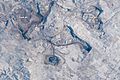
Coal mines near Gillette, seen from the ISS in 2015
-
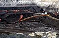
A large surface coal mine near Gillette


See also
 In Spanish: Gillette (Wyoming) para niños
