
Denver facts for kids
Quick facts for kids
Denver
|
|||||
|---|---|---|---|---|---|
|
State capital and consolidated city-county
|
|||||
|
|||||
| Nicknames: | |||||

Denver
Location in Colorado

Denver
Location in the United States
|
|||||
| Country | United States | ||||
| State | Colorado | ||||
| City and county | Denver | ||||
| Platted | November 17, 1858, as Denver City, Kansas Territory |
||||
| Incorporated | November 7, 1861, as Denver City, Colorado Territory |
||||
| Consolidated | December 1, 1902, as the City and County of Denver |
||||
| Named for | James W. Denver | ||||
| Government | |||||
| • Type | Consolidated city and county | ||||
| • Body | Denver City Council | ||||
| Area | |||||
| • Total | 154.726 sq mi (400.739 km2) | ||||
| • Land | 153.075 sq mi (396.463 km2) | ||||
| • Water | 1.651 sq mi (4.276 km2) | ||||
| • Metro | 8,403.00 sq mi (21,763.67 km2) | ||||
| Elevation | 5,280 ft (1,610 m) | ||||
| Highest elevation | 5,680 ft (1,730 m) | ||||
| Lowest elevation | 5,130 ft (1,560 m) | ||||
| Population
(2020)
|
|||||
| • Total | 715,522 | ||||
| • Estimate
(2023)
|
716,577 |
||||
| • Rank | 58th in North America 19th in the United States 1st in Colorado |
||||
| • Density | 4,674/sq mi (1,805/km2) | ||||
| • Urban | 2,686,147 (US: 18th) | ||||
| • Urban density | 4,167.5/sq mi (1,609.1/km2) | ||||
| • Metro | 2,963,821 (US: 19th) | ||||
| • CSA | 3,623,560 (US: 17th) | ||||
| • Front Range | 5,055,344 | ||||
| Demonym(s) | Denverite | ||||
| GDP | |||||
| • Total | $118.569 billion (2023) | ||||
| • Metro | $311.876 billion (2023) | ||||
| Time zone | UTC−07:00 (MST) | ||||
| • Summer (DST) | UTC−06:00 (MDT) | ||||
| ZIP Codes |
80012, 80014, 80022, 80033, 80123, 80201–80212, 80214–80239, 80241, 80243–80244, 80246–80252, 80256–80257, 80259-80261, 80263-80266, 80271, 80273–80274, 80279–80281, 80290–80291, 80293–80295, 80299
|
||||
| Area codes | 303/720/983 | ||||
| FIPS code | 08-20000 | ||||
| GNIS feature ID | 201738 | ||||
|
|
|||||

.jpg)


Denver is a major city in the western United States. It is the capital and largest city of Colorado. Denver is known as the "Mile High City" because its official elevation is exactly one mile (5,280 feet) above sea level. This special spot is marked on the steps of the Colorado State Capitol building.
The city is located in the South Platte River Valley, on the edge of the High Plains. It sits just east of the Front Range of the Rocky Mountains. Denver is a "consolidated city and county," which means the city and county governments are combined into one.
As of 2020, Denver had a population of over 715,000 people. This makes it the 19th most populated city in the United States. The larger Denver metropolitan area, which includes nearby cities like Aurora and Lakewood, has almost 3 million people. This makes it the largest metropolitan area in Colorado. Denver is a big center for business and culture in the wider Front Range Urban Corridor, where more than 5 million people live.
Denver's downtown area is about 12 miles (19 km) east of the Rocky Mountains' foothills. The city was founded in 1858 during the Gold Rush. It was named after James W. Denver, who was the governor of the Kansas Territory at the time. Denver quickly grew from a mining town into an important center for trade and transportation for the Great Plains and Rocky Mountain West.
Denver is a major cultural hub with many museums and arts centers. These include the Denver Performing Arts Complex and the Denver Art Museum. The city also has professional sports teams in all five major leagues. In 2016, U.S. News & World Report named Denver the best place to live in the United States, thanks to its sunny weather and easy access to nature.
Contents
- History of Denver: From Gold Rush to Modern City
- Geography of Denver: The Mile-High City's Location
- Demographics of Denver: A Diverse Community
- Economy of Denver: A Hub for Business and Innovation
- Culture in Denver: Arts, Sports, and Outdoor Fun
- Sports in Denver: Home to Major League Teams
- Parks and Recreation in Denver: Green Spaces and Mountain Views
- Education in Denver: Schools and Universities
- Media in Denver: News, Radio, and TV
- Transportation in Denver: Getting Around the City
- Notable People from Denver
- Sister Cities of Denver
- Images for kids
- See also
History of Denver: From Gold Rush to Modern City
Early Settlements and Gold Discovery


Long before Denver was founded, the area was home to several Native American tribes. These included the Apaches, Utes, Cheyennes, Comanches, and Arapahoes. In 1858, gold was discovered in the Rocky Mountains. This led to a "gold rush" and many people moved into the area.
In the summer of 1858, gold prospectors from Kansas started a mining town called Montana City. This was the first settlement in what would become Denver. However, this town was soon abandoned. People moved to other nearby settlements like Auraria and St. Charles City.
On November 22, 1858, General William Larimer and Captain Jonathan Cox claimed land across from Auraria. Larimer named this new town "Denver City." He hoped to gain favor with Kansas Territorial Governor James W. Denver. The location was good because it was near existing trails and Native American camps.
Growth and Development of Denver City
Denver City quickly became a frontier town. Its economy focused on providing services to miners, like gambling and trading goods. In 1859, residents helped build the region's first overland wagon route. This route cut travel time from twelve days to six. In 1863, Western Union chose Denver for its regional office, which further boosted the city's importance.
On February 28, 1861, the Colorado Territory was created. Denver City was officially incorporated on November 7, 1861. It became the county seat of Arapahoe County. In 1867, Denver City became the temporary capital of the territory. In 1881, it was chosen as the permanent state capital. At this time, Denver City shortened its name to just Denver. Colorado officially became a state on August 1, 1876.
Connecting to the Nation
A big challenge for Denver was that the first transcontinental railroad bypassed the city. It was built 100 miles (160 km) away in Cheyenne City. Denver's citizens worked hard to build their own railroad to connect to the main line. Leaders like Governor John Evans helped raise money. On June 24, 1870, the Denver Pacific railroad link was completed. This brought a new era of growth and wealth to Denver.
The city grew rapidly, attracting wealthy people who built grand mansions. Luxurious hotels and opera houses also appeared. Denver's leaders wanted to make it a world-class city. They attracted industries and workers.
Challenges and Changes in Denver
As Denver grew, it welcomed many immigrants from Germany, Italy, and China. Later, African Americans and Hispanic workers also moved to the city. This growth sometimes led to social tensions.
Between 1880 and 1895, the city faced problems with corruption. In 1893, Denver experienced an economic downturn when silver prices crashed. However, the community also showed its strength. In 1887, the organization that would become United Way was formed in Denver to help the poor. By 1890, Denver was the second-largest city west of Omaha, Nebraska.
From the 1880s to the 1930s, Denver's flower-growing industry became very successful. This period was known as the "Carnation Gold Rush."
In 1902, Denver became a "consolidated city and county." This meant its city and county governments merged into one.
Modern Denver: Growth and Environmental Awareness
From 1953 to 1989, the Rocky Flats Plant, a nuclear weapons facility, operated near Denver. This plant produced parts for nuclear warheads. There were concerns about radioactive contamination from the site affecting parts of Denver.
In 1970, Denver was chosen to host the 1976 Winter Olympics. However, in 1972, Colorado voters decided not to use public money for the games. This was largely due to environmental concerns. Denver became the only city to ever decline hosting the Olympics after being chosen.
In 2010, Denver updated its zoning rules to guide future development. Denver has hosted the Democratic National Convention twice, in 1908 and 2008. In 1993, Denver hosted the Catholic Church's 6th World Youth Day, which was the largest gathering in Colorado's history.
Denver has historically been known as the Queen City of the Plains because of its important role in agriculture in the High Plains region.
Geography of Denver: The Mile-High City's Location


Denver is located in the middle of the Front Range Urban Corridor. This area stretches between the Rocky Mountains to the west and the High Plains to the east. The city's landscape includes flat plains in the center and hilly areas to the north, west, and south.
The City and County of Denver covers about 154.7 square miles (400.7 square kilometers). A small part of this area is water. Denver is surrounded by three other counties: Adams County to the north and east, Arapahoe County to the south and east, and Jefferson County to the west.
Denver's famous nickname, the "Mile-High City," comes from its official elevation of 5,280 feet (1 mile) above sea level. This exact spot is marked on the steps of the State Capitol building. The city's elevation actually ranges from 5,130 feet (1,564 meters) to 5,690 feet (1,734 meters). Denver is about 746 miles (1,200 km) from the nearest ocean, the Gulf of California.
Denver's Neighborhoods: Unique Areas to Explore

As of 2013, Denver has 78 official neighborhoods. These are used by the city and community groups for planning. The neighborhoods have very different styles. Some have tall skyscrapers, while others have historic 19th-century houses or modern suburban developments.
Neighborhoods closer to the city center are usually older and more densely built, often with brick buildings. Many neighborhoods further from the center were built after World War II with newer materials and styles. Some newer developments try to recreate the feel of older neighborhoods.
Denver doesn't have larger area names like some other cities. Instead, people often refer to areas as "north," "south," "east," and "west."

Some well-known neighborhoods not officially defined by the city include LoDo (short for "Lower Downtown"), which is part of the Union Station area. Other popular areas are Uptown, Curtis Park, and Park Hill, known for its successful racial integration. The Golden Triangle is another notable area.
One of Denver's newer neighborhoods was built on the site of the former Stapleton International Airport. In 2020, the community voted to change the neighborhood's name from Stapleton to Central Park. This was because the airport was named after a former mayor who was a member of the Ku Klux Klan. The Central Park neighborhood itself has 12 smaller "neighborhoods" within its borders.
Denver's Climate: Sunny Days and Snowy Winters
| Weather chart for Denver | |||||||||||||||||||||||||||||||||||||||||||||||
|---|---|---|---|---|---|---|---|---|---|---|---|---|---|---|---|---|---|---|---|---|---|---|---|---|---|---|---|---|---|---|---|---|---|---|---|---|---|---|---|---|---|---|---|---|---|---|---|
| J | F | M | A | M | J | J | A | S | O | N | D | ||||||||||||||||||||||||||||||||||||
|
0.4
45
19
|
0.4
46
20
|
0.9
56
28
|
1.7
62
34
|
2.2
71
44
|
1.9
83
53
|
2.1
90
60
|
1.6
88
58
|
1.4
80
50
|
1
65
37
|
0.6
53
26
|
0.4
44
18
|
||||||||||||||||||||||||||||||||||||
| temperatures in °F precipitation totals in inches |
|||||||||||||||||||||||||||||||||||||||||||||||
|
Metric conversion
|
|||||||||||||||||||||||||||||||||||||||||||||||
Denver has a continental semi-arid climate. This means it has four distinct seasons, generally low humidity, and lots of sunshine (around 3,100 hours per year). Because of its location on the High Plains at the foot of the Rocky Mountains, Denver's weather can change suddenly.
July is the warmest month, with average high temperatures around 90°F (32°C). Summers are warm to hot, with occasional thunderstorms. Highs can reach 90°F (32°C) about 38 days a year, and sometimes even 100°F (38°C). December is the coldest month, with average daily highs around 44°F (7°C).
Winters have periods of snow and cold temperatures, but also milder weather due to warming Chinook winds. Snowfall is common from late fall through early spring, averaging about 53.5 inches (136 cm) per year. The earliest measurable snow has been in September, and the latest in June. Temperatures can range from -29°F (-34°C) to 105°F (41°C).

Demographics of Denver: A Diverse Community
| Historical population | |||
|---|---|---|---|
| Census | Pop. | %± | |
| 1860 | 4,749 | — | |
| 1870 | 4,759 | 0.2% | |
| 1880 | 35,629 | 648.7% | |
| 1890 | 106,713 | 199.5% | |
| 1900 | 133,859 | 25.4% | |
| 1910 | 213,381 | 59.4% | |
| 1920 | 256,491 | 20.2% | |
| 1930 | 287,861 | 12.2% | |
| 1940 | 322,412 | 12.0% | |
| 1950 | 415,765 | 29.0% | |
| 1960 | 493,887 | 18.8% | |
| 1970 | 514,678 | 4.2% | |
| 1980 | 492,686 | −4.3% | |
| 1990 | 467,610 | −5.1% | |
| 2000 | 554,636 | 18.6% | |
| 2010 | 600,158 | 8.2% | |
| 2020 | 715,522 | 19.2% | |
| 2023 (est.) | 716,577 | 19.4% | |
| U.S. Decennial Census | |||
As of the 2020 census, Denver's population was 715,522. This makes it the 19th most populated city in the U.S. The larger Denver metropolitan area is the 19th most populated in the U.S. People who live in Denver are sometimes called "Denverites."

In 2020, Denver had 301,501 households. The population density was about 3,923 people per square mile (1,515 per square kilometer). In 2017, U.S. News & World Report ranked Denver as a top place to live, noting its affordability and good quality of life.
.png)
Diversity in Denver: A Mix of Cultures
Denver is a diverse city. According to the 2020 census:
- About 54.9% of the population was White (not Hispanic).
- About 29.3% of the population was Hispanic or Latino (of any race). Most of these were of Mexican descent.
- About 9.8% of the population was Black or African American.
- About 4.1% of the population was Asian.
- About 1.7% of the population was Native American.
- About 0.2% of the population was Native Hawaiian and Other Pacific Islander.
- About 3.3% of the population was Two or more races.
Most people (70.3%) over five years old spoke only English at home. About 23.5% of the population spoke Spanish at home. Other languages spoken include Vietnamese, African languages, Russian, Chinese, and French.
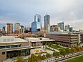
Economy of Denver: A Hub for Business and Innovation


.JPG)
Denver's economy is strong, with a gross metropolitan product of $157.6 billion in 2010. This made it the 18th largest metro economy in the U.S. Denver's location helps its economy. It is the largest city within 500 miles (800 km). This makes it a natural place for storing and distributing goods and services. Denver is also roughly halfway between major cities in the Midwest and on the West Coast.
Many well-known companies started in Denver or moved their headquarters there. For example, Samsonite luggage began in Denver in 1910. Continental Airlines (now part of United Airlines) moved its headquarters to Denver in 1937. The Gates Corporation, a big producer of automotive belts and hoses, was founded in Denver in 1919. Re/Max, a real estate company, made Denver its headquarters in 1973. Newmont Mining Corporation, one of the world's largest gold producers, is also based in Denver.

Denver also has a significant government presence. Many federal agencies have offices in the Denver area. This brings jobs to the city. Being the state capital of Colorado also adds to its economy. The Denver Federal Center and the Denver Mint are examples of federal facilities here.
In 2005, the Colorado Convention Center was expanded. This helped Denver become a top city for hosting conventions.
Denver's location near the mineral-rich Rocky Mountains has led to many mining and energy companies. In the city's early days, gold and silver booms were very important. In the 1970s and 1980s, an energy crisis led to an oil boom in Denver. This caused many new skyscrapers to be built downtown. Even though the oil industry faced challenges later, energy and mining are still important today.

Denver's time zone also helps the telecommunications industry. It allows communication with both North American coasts, South America, Europe, and Asia on the same business day. Companies like Dish Network Corporation and Comcast have operations in Denver.
Denver has also been a leader in the fast-casual restaurant industry. Many popular restaurant chains, like Quiznos and Smashburger, were founded in Denver. Chipotle Mexican Grill also started in Denver.
In 2015, Forbes magazine ranked Denver as the No. 1 best place for business and careers.
Top Employers in Denver
Here are some of the largest employers in Denver:
| # | Employer | Number of employees |
|---|---|---|
| 1 | City and County of Denver | 13,584 |
| 2 | Denver Public Schools | 12,693 |
| 3 | State of Colorado Central Payroll | 10,686 |
| 4 | Denver Health & Hospital Authority | 9,502 |
| 5 | United Airlines | 7,230 |
| 6 | CHI Payroll Agent (HCA Health One) | 4,592 |
| 7 | University of Denver | 4,548 |
| 8 | USDA National Finance Center | 4,496 |
| 9 | Southwest Airlines | 4,247 |
| 10 | ADP TotalSource | 2,535 |
Culture in Denver: Arts, Sports, and Outdoor Fun

Denver has a rich cultural scene. Apollo Hall, one of the city's first theaters, opened in 1859. In the 1880s, Horace Tabor built Denver's first opera house. Early in the 20th century, city leaders started a "city beautification" program. This created many of Denver's parks, parkways, and museums, including the Municipal Auditorium (now the Ellie Caulkins Opera House).
Since 1988, voters in the Denver area have approved a special sales tax called the Scientific and Cultural Facilities Tax (SCFD). This tax helps fund many cultural and scientific organizations throughout the region.
Museums and Art Districts
Denver is home to many museums. The Denver Art Museum has a new wing designed by architect Daniel Libeskind. The Denver Performing Arts Complex is the second-largest performing arts center in the U.S. after Lincoln Center in New York City. Neighborhoods like LoDo are full of art galleries, restaurants, and clubs.
The city also has the Clyfford Still Museum, dedicated to the abstract expressionist painter. The Denver Museum of Nature and Science has amazing exhibits, including a valuable aquamarine specimen. The state history museum, History Colorado Center, opened in 2012. It offers interactive exhibits about Colorado's past.
Denver has several art districts, such as Denver's Art District on Santa Fe and the River North Art District (RiNo).
Music and Outdoor Activities
Denver has a lively music scene, including pop, jazz, folk, metal, and classical music. Famous folk artists like Bob Dylan and Judy Collins lived and performed in Denver in the 1960s and 70s. More recent Denver-based artists include The Lumineers and The Fray.
Because it's close to the mountains and has sunny weather, Denver is known as an active, outdoor-oriented city. Many residents enjoy skiing in the winter and hiking, climbing, kayaking, and camping in the summer.
Denver and its surrounding cities have many local and national breweries. The city hosts the annual Great American Beer Festival each fall, attracting visitors from around the world.
Traditions and Food
For over a century, Denver has hosted the annual National Western Stock Show. This event celebrates the city's history as a major trading center for beef and livestock. It attracts thousands of animals and hundreds of thousands of visitors every January.
Denver has a large population of Mexican Americans. The city hosts several big Mexican-American celebrations, including Cinco de Mayo and the annual Lowrider show. Denver is also known for its New Mexican cuisine, especially its green and red chile sauce, Colorado burrito, and chiles rellenos. Other local foods include Rocky Mountain oysters and the Denver sandwich.
The Dragon Boat Festival in July and the Moon Festival in September are annual events for Denver's Chinese and Asian-American communities.
Denver is known for being welcoming to the LGBTQ community. Every June, Denver hosts the annual Denver PrideFest, the largest LGBTQ Pride festival in the Rocky Mountain region.
-
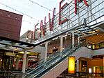
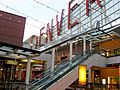
Denver Pavilions is a popular arts, entertainment, and shopping center on the 16th Street Mall in downtown Denver.
-
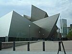
Denver Art Museum
-

Civic Center Park, with museums and the central library in background


Sports in Denver: Home to Major League Teams


Denver is a major sports city. It is one of only 12 U.S. cities with teams in all four major professional sports leagues. Including soccer, it has five major sports teams.
- The Denver Broncos are the city's NFL team. They have won the Super Bowl three times (1997, 1998, and 2015). Their home stadium is Empower Field at Mile High.
- The Colorado Rockies are Denver's MLB team. They play at Coors Field. In 2007, they reached the World Series for the first time.
- The Denver Nuggets play in the NBA. They won their first NBA championship in 2023.
- The Colorado Avalanche are Denver's NHL team. They have won the Stanley Cup three times (1996, 2001, and 2022). Both the Nuggets and Avalanche play at Ball Arena.
- The Colorado Rapids are Denver's MLS team. They play at Dick's Sporting Goods Park in Commerce City and won the MLS Cup in 2010.
Denver also has other professional teams, including the Colorado Mammoth (lacrosse). In 2018, the Denver Bandits were formed as the first professional women's football team in Colorado.
Denver was chosen to host the 1976 Winter Olympics, but the city later decided not to host them. This makes Denver the only city to ever decline the Olympics after winning the bid.
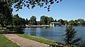
Parks and Recreation in Denver: Green Spaces and Mountain Views


Denver has over 200 parks, from small neighborhood parks to the large 314-acre (1.27 km²) City Park. The city also has 29 recreation centers.
Many of Denver's parks were created in the late 19th and early 20th centuries. Mayor Robert Speer (1904–12 and 1916–18) worked to expand and beautify the city's parks. Landscape architects like Reinhard Schuetze and Frederick Law Olmsted Jr. helped design parks such as Washington Park, Cheesman Park, and Civic Center Park. The Denver Botanic Gardens are located next to Cheesman Park.
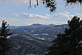
Denver also owns and maintains about 14,000 acres (57 km²) of mountain parks. These include Red Rocks Park, famous for its beautiful scenery and the Red Rocks Amphitheatre. Denver even owns the mountain where the Winter Park Resort ski area operates, about 67 miles (108 km) west of the city.
Since 1974, Denver has worked to clean up the South Platte River and its smaller rivers. This has created greenways for hikers and cyclists. The South Platte River Greenway is considered one of the best urban cleanup projects in the U.S.
In 2022, Denver's park system was ranked 18th best among the 50 most populated U.S. cities. This report noted that 89% of Denver residents live within a 10-minute walk of a park.
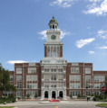
Education in Denver: Schools and Universities


Denver Public Schools (DPS) is the public school system for the entire city of Denver. It serves about 92,000 students in many elementary, middle, and high schools, as well as charter schools. The first school in what is now DPS opened in 1859.
Denver has many colleges and universities. Three large public schools share the Auraria Campus: the University of Colorado Denver, Metropolitan State University of Denver, and Community College of Denver. The private University of Denver was the first higher education institution in the city, founded in 1864. Other notable schools include Johnson & Wales University and Regis University.
Media in Denver: News, Radio, and TV
The Denver area has many different media outlets, including newspapers, radio stations, television channels, and online news.
Television Stations in Denver
Denver is the 16th largest market in the country for television. Here are some of the main TV stations:
- KWGN-TV, channel 2 (CW affiliate)
- KCNC-TV, channel 4 (CBS affiliate)
- KRMA-TV, channel 6 (PBS affiliate)
- KMGH-TV, channel 7 (ABC affiliate)
- KUSA-TV, channel 9 (NBC affiliate)
- KDEN-TV, channel 25 (Telemundo affiliate)
- KCEC, channel 50 (Univision affiliate)
Radio Stations in Denver
Denver is served by over 40 AM and FM radio stations. They offer a wide variety of music and talk shows. The Denver–Boulder radio market is the 19th largest in the United States.
Print Media in Denver
For many years, Denver had two main newspapers: The Denver Post and the Rocky Mountain News. They merged operations in 2001. In 2009, the Rocky Mountain News closed. There are also several other newspapers and magazines published in Denver, such as Westword and 5280 magazine, named after the city's mile-high elevation.
Transportation in Denver: Getting Around the City

City Streets and Bike Paths

Most of Denver has a simple street grid that runs north-south and east-west. Streets are numbered or named based on their distance from central lines. Colfax Avenue is a major east-west road.
Downtown Denver has an older grid system. Its streets run northeast-southwest and northwest-southeast. This design helps melt snow faster because streets get sunlight at different times of the day. This idea came from Henry Brown, the founder of the Brown Palace Hotel.

Denver has over 850 miles (1,370 km) of paved bike paths in parks and along rivers like Cherry Creek and the South Platte. This makes Denver a very bicycle-friendly city. Many people commute by bike. In 2010, Denver launched B-Cycle, a citywide bicycle sharing program.
Freeways and Highways
Denver is mainly served by two major interstate highways: I-25 (running north-south) and I-70 (running east-west). The intersection of these two interstates is often called "the mousetrap" because of its complex design.
Other important highways include:
 Interstate 225: A highway that goes through Aurora, connecting I-25 and I-70.
 US 6: Connects downtown Denver to western suburbs like Golden and Lakewood.
 US 36: Connects Denver to Boulder and Rocky Mountain National Park.
Denver also has a nearly complete beltway called "the 470's." This includes SH 470 and two toll highways, E-470 and Northwest Parkway.
Public Transportation in Denver


Public transportation in the Denver area is managed by the Regional Transportation District (RTD). RTD operates over 1,000 buses and ten rail lines. These lines include both light rail and commuter rail, serving many stations in Denver and surrounding areas.
The FasTracks project is expanding Denver's rail and bus system. The W Line (West line) opened in 2013. The A Line, connecting downtown to Denver International Airport, opened in 2016. The R Line through Aurora opened in 2017.
An express bus service called the Flatiron Flyer connects Boulder and Denver.
Amtrak, the national passenger rail system, serves Denver at the historic Union Station. From here, travelers can connect to RTD's local transit. The Winter Park Express also runs from Union Station to the Winter Park Ski Resort during the winter.
Airports Serving Denver


Denver International Airport (DIA) is the main airport for the Denver area. It is about 18.6 miles (30 km) east-northeast of the Colorado State Capitol. DIA opened in 1995. It is one of the busiest airports in the world, serving millions of passengers each year. DIA is also the largest airport in the United States by land area, covering more than 52.4 square miles (135.7 km²). It is a major hub for United Airlines and the headquarters for Frontier Airlines.
In 2017, Skytrax rated Denver International Airport as the 28th-best airport globally.
There are also three smaller airports for general aviation in the Denver area: Rocky Mountain Metropolitan Airport, Centennial Airport, and Colorado Air and Space Port.
In the past, Denver had other airports that are no longer in use. Stapleton International Airport closed in 1995 when DIA opened. Lowry Air Force Base also closed in 1994. Both of these former airport sites have been redeveloped into neighborhoods.
Notable People from Denver
- List of people from Denver
Sister Cities of Denver
Denver has special relationships with cities around the world, called "sister cities." The first sister city relationship was with Brest, France, starting in 1948. This began when a Denver teacher visited Brest after World War II and her students raised money to help rebuild a hospital there.
Since then, Denver has formed relationships with many other sister cities:
 Brest, France (1948)
 Takayama, Japan (1960)
 Nairobi, Kenya (1975)
 Karmiel, Israel (1977)
 Cuernavaca, Mexico (1983)
 Potenza, Italy (1983)
 Chennai, India (1984)
 Kunming, China (1985)
 Axum, Ethiopia (1995)
 Ulaanbaatar, Mongolia (2001)
 Akureyri, Iceland (2012)
Images for kids
-
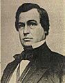
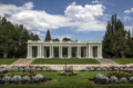
Former Kansas Territorial Governor James W. Denver visited his namesake city in 1875 and in 1882.
-
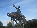
The "Bronco Buster", a variation of Frederic Remington's "Bronco Buster" Western sculpture at the Denver capitol grounds, a gift from J.K. Mullen in 1920.
-
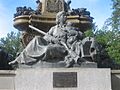
"Pioneer Mothers of Colorado" statue at The Denver Post building.
-
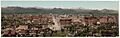
Panoramic print of Denver, 1898.
-
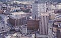
Downtown Denver cityscape, 1964. Includes Denver's oldest church (Trinity United Methodist), first building of the Mile High Center complex, Lincoln Center, old brownstone part of the Brown Palace Hotel, and Cosmopolitan Hotel – since demolished.
-

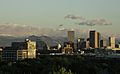
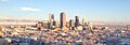
Panorama of Denver in early May, as seen from the Denver Museum of Nature and Science. Snow-capped Mount Evans can be seen to the left beyond the city skyline.
-
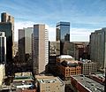
Central Downtown Denver.
-
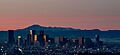
Denver and nearby mountains as seen from the rooftops of the Cherry Creek neighborhood.
-
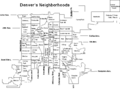
Denver's 78 official neighborhoods.
-
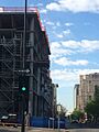
Construction along Cherokee Street in the Golden Triangle neighborhood.
-
View of downtown Denver after a snowstorm in March 2016, looking northwest from Cheesman Park.
-

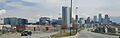
Panorama of downtown Denver, c. 2006, looking east along Speer Blvd.
-
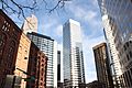
The 17th street district includes many financial, business and corporate buildings.
-
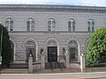
The United States Mint in Denver (2010).
-
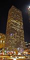
Republic Plaza, Colorado's tallest building.
-
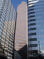
Wells Fargo "Cash Register" building.
-
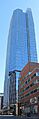
1144 15th St: One of Denver's newest skyscrapers.
-
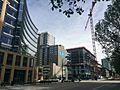
Development in the bustling Union Station section of downtown.
-
The first Chipotle Mexican Grill, near the campus of the University of Denver.
-
Denver Pavilions is a popular arts, entertainment, and shopping center on the 16th Street Mall in downtown Denver.
-

Denver Art Museum.
-
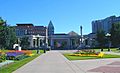
Civic Center Park, with museums and the central library in background.
-
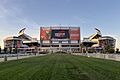
Empower Field at Mile High, home of the Denver Broncos of the National Football League (NFL).
-
Ball Arena, home to the Denver Nuggets of the National Basketball Association (NBA), the Colorado Avalanche of the National Hockey League (NHL), and the Colorado Mammoth of the National Lacrosse League (NLL).
-
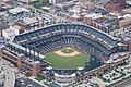
Coors Field, home of the Colorado Rockies of Major League Baseball (MLB).
-

Dick's Sporting Goods Park, home of the Colorado Rapids of Major League Soccer (MLS).
-
Cheesman Park started as a cemetery.
-
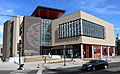
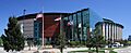
The Carla Madison Recreation Center, completed in 2017.
-
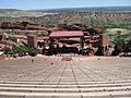
Red Rocks is a Denver park and world-famous amphitheater in the foothills.
-
Washington Park.
-
Genesee Park is the largest of the Denver Mountain Parks.
-
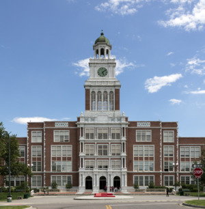
Denver East High School.
-
University of Colorado-Denver in downtown.
-
The Ritchie Center at University of Denver.
-
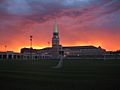
Dawn over downtown Denver, viewed from the north with Pikes Peak and the southern Front Range to the south.
-
Colfax Avenue at Broadway, where the downtown street grid and the "normal" city grid meet. Colfax Avenue carries U.S. Highway 40 through Denver.
-
Speer Boulevard runs north–south through downtown Denver.
-
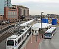
Denver RTD light rail and bus lines.
-
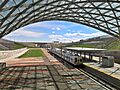
Commuter rail station at Denver International Airport.
-
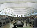
Inside the main terminal of Denver International Airport.
-
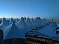
Outside view of the main terminal, DIA.


See also
 In Spanish: Denver para niños
