
Plat facts for kids

A plat, also called a plan, is a special map. It shows how a large piece of land is divided. These divisions are made so that houses, businesses, or other buildings can be built. Plats are very important in the United States when new neighborhoods or towns are planned.
After a plat map is officially recorded, land can be described more easily. Instead of using complex descriptions of land sections, people can use simple block and lot numbers. This makes buying, selling, and managing land much clearer.
Contents
What is a Plat Map?
A plat map is like a detailed blueprint for land. It shows exactly where property lines are located. It also marks streets, alleys, and areas set aside for public use, like parks or schools. Surveyors, who are experts in measuring land, create these maps. They use precise tools to make sure every measurement is correct.
Why Plats Are Important
Plats are crucial for several reasons:
- Organized Growth: They help communities grow in an organized way. Without plats, it would be hard to plan for roads, utilities, and public services.
- Clear Ownership: Plats clearly define each piece of property. This helps prevent arguments between neighbors about where one property ends and another begins.
- Legal Records: Once a plat is approved and filed, it becomes a legal document. This means it is an official record of how the land is divided.
How Plats Are Used
Plat maps are used by many different people and groups.
For Homeowners and Buyers
If you buy a house in a new neighborhood, your property was likely created from a plat map. The map shows the exact size and shape of your lot. It also shows any easements, which are parts of your land that someone else might have the right to use, like for power lines.
For City Planners
City planners use plats to design new areas. They decide where roads will go, where houses can be built, and where businesses or parks should be located. Plats help them make sure there is enough space for everything a community needs.
For Developers
Land developers buy large pieces of land. They then use plats to divide that land into smaller lots to sell for building homes or businesses. The plat shows them how many lots they can create and where to put streets and utilities.
The Platting Process
Creating and approving a plat map involves several steps.
Surveying the Land
First, a professional land surveyor measures the land. They mark the boundaries and important features. They create a detailed drawing of the existing land.
Designing the Layout
Next, the developer or planner designs how the land will be divided. They decide on the size and shape of each lot. They also plan the layout of streets, sidewalks, and any public spaces.
Approval and Filing
The proposed plat map must be approved by local government officials. This often involves city councils or planning commissions. They check if the plat follows all local rules and regulations. Once approved, the plat is officially filed with the county recorder's office. This makes it a public legal record.
Legal Descriptions and Plats
Before plats, land was often described using natural landmarks or complex measurements. For example, a property might be described as "the land starting at the old oak tree, going east to the creek, then north to the large rock." This could be confusing.
With a filed plat, land can be described simply by its "block and lot number." For example, "Lot 5, Block 2, of the Green Valley Subdivision Plat." This is a much clearer and more precise way to identify a specific piece of property. It makes legal documents, like deeds, much easier to understand.
Images for kids
-
A pamphlet for a walking tour of Boise's original ten blocks.
-
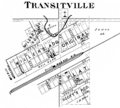
An 1878 plat map of Transitville (now Buck Creek, Indiana)


See also
 In Spanish: Plano (cartografía) para niños
