South Platte River facts for kids
Quick facts for kids South Platte River |
|
|---|---|
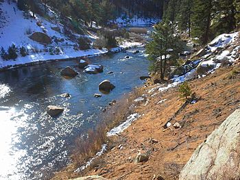
South Platte River in Douglas County, Colorado,
|
|
 |
|
| Native name | Wašíŋ Wakpá |
| Physical characteristics | |
| Main source | Confluence of South Fork and Middle Fork 39°00′40″N 105°44′25″W / 39.01111°N 105.74028°W |
| River mouth | Confluence with North Platte River 2,762 ft (842 m) 41°06′50″N 100°40′33″W / 41.11389°N 100.67583°W |
| Length | 439 mi (707 km) |
| Basin features | |
| Progression | Platte—Missouri—Mississippi |
| Discharge range | 0 to 4,640 cu ft/s (0 to 131 m3/s) |
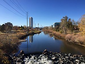
The South Platte River is a very important river in the western United States. It is one of the two main rivers that join to form the Platte River. This river flows through the states of Colorado and Nebraska. It is a big part of the American Midwest and Mountain West regions.
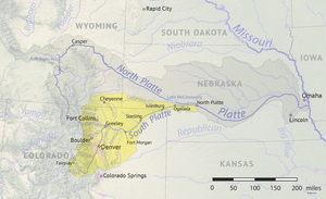
The river's drainage basin (the area of land where all the water drains into the river) covers a large part of the eastern side of the Rocky Mountains in Colorado. It also includes many populated areas like the Colorado Front Range and the Eastern Plains. A small part of southeastern Wyoming, near the city of Cheyenne, is also in its basin. The South Platte River meets the North Platte River in western Nebraska. Together, they form the Platte River, which then flows across Nebraska to the Missouri River. The South Platte River is the main source of water for eastern Colorado. Its valley along the foothills in Colorado has allowed farming to happen in an area that is usually very dry.
Contents
Where Does the South Platte River Begin and End?
The South Platte River starts in Park County, Colorado. This is southwest of Denver in a large grassy area called South Park. It forms where two smaller rivers, the South Fork and Middle Fork, meet. This spot is about 15 mi (24 km) southeast of Fairplay. Both of these forks begin on the eastern side of the Mosquito Range. This mountain range is on the western edge of South Park.
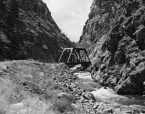
From South Park, the river flows through about 50 mi (80 km) of Platte Canyon. It then reaches its lower part, called Waterton Canyon. Here, another river, the North Fork, joins it. The river then comes out of the foothills southwest of Littleton, a suburb of Denver. In Littleton, the river is held back by a dam to create Chatfield Reservoir. This reservoir helps control floods for the Denver metropolitan area.
The River's Journey Through Colorado and Nebraska
The South Platte River flows north through the center of Denver. The city of Denver was actually started along the river's banks, where it meets Cherry Creek. The river valley through Denver is very industrial. It is often used as a path for both railroad lines and Interstate 25. North of Denver, Clear Creek quietly joins the river. Clear Creek comes from the mountains to the west, flowing through a canyon. This canyon was important during the Pike's Peak Gold Rush.
North of Denver, the river flows through a farming area called the Piedmont. This area has a lot of shale rock, which was formed by the river's ancestors eroding the land after the Rocky Mountains were created. The river flows past towns like Brighton and Fort Lupton. Several other rivers and creeks join it here. These include Saint Vrain Creek, the Little Thompson River, the Big Thompson River, and the Cache la Poudre River. The Cache la Poudre River joins the South Platte just east of Greeley.
East of Greeley, the river turns eastward. It flows across the Colorado Eastern Plains, passing Fort Morgan and Brush. Then it turns northeast. It continues past Sterling and enters Nebraska between Julesburg, Colorado, and Big Springs, Nebraska. In Nebraska, it flows south of Ogallala. Finally, it joins the North Platte River near the city of North Platte.
Water Quality and Concerns
The South Platte River, especially the part that flows through Denver, is monitored for water quality. The U.S. Environmental Protection Agency (US EPA) has listed it as an "impaired waterbody" because of certain bacteria, like E. coli. Other concerns for the river's health include the presence of invasive species. These include the New Zealand mud snail and the zebra mussel. These species can harm the natural environment of the river.
A Look Back at the South Platte River's History
The native Arapaho people, who lived along the river, called it Niinéniiniicíihéhe. Early Spanish explorers gave it the name Rio Chato, meaning "calm river." In 1702, Captain Jose Lopez named it the Rio Jesus Maria. He was a scout and captain from New Mexico, sent to explore new lands for the Spanish.
The South Platte River has always been a key water source in Colorado. Long before Denver was built, many travelers came to the river. They needed its water to survive the dry Great Plains. For a while, people used buckets and wells to get water. But as more people arrived, a larger water system was needed. This led to the creation of the Denver Water System.
Dams Along the South Platte River
Because the region is very dry, several dams have been built on the South Platte River. These dams help store water for people and farming.
- Antero Reservoir: This is the first important dam on the South Platte River, located near where the river begins. Its name, "Antero," comes from a Spanish word meaning "first."
- Spinney Mountain Reservoir: This reservoir can cover about 2,500 acres (10 km2) when full. It releases water from its bottom, east of where the river flows in.
- Eleven Mile Reservoir: About two miles below Spinney Mountain, the river enters Eleven Mile Reservoir. This large reservoir can hold 97,000 acre-feet (120,000,000 m3) of water. The dam here drains into Eleven Mile Canyon. Three old Colorado towns—Howbert, Idlewild, and Freshwater Station—were covered by the reservoir. This happened to provide water for Denver.
- Cheesman Reservoir: From Eleven Mile Canyon, the South Platte flows northeast to Cheesman Reservoir. It is named after Walter S. Cheesman, an important person in Denver's water history. When it was finished in 1905, this dam was the tallest in the world, standing 221 ft (67 m) above the riverbed. The Denver Water Board bought the reservoir and its facilities in 1918. Cheesman was Denver's first mountain water storage facility. It has been recognized as a National Historic Civil Engineering Landmark. Cheesman Reservoir feeds Cheesman Canyon.
- Strontia Springs Reservoir: After Cheesman Canyon, the river flows past the town of Deckers. It then bends north towards the North Fork of the South Platte. From this meeting point, the river flows towards Denver and enters Strontia Springs Reservoir.
- Chatfield Reservoir: Below Strontia Springs, the South Platte flows through Waterton Canyon. Then it enters Chatfield Reservoir. Chatfield is the seventh and final dam on the South Platte before it joins the North Platte River.
In the late 1980s, there was a plan for a new dam called Two Forks Dam. This dam would have created a huge reservoir, flooding the entire area from the North Fork meeting point to Deckers. However, in 1990, the US EPA stopped the project. They said it would be very bad for the environment.
Fly Fishing in the South Platte River
The South Platte River is famous for fly fishing in Colorado. It is known as a "gold medal" trout river. This means it has many large, wild brown and rainbow trout. Because it is close to Denver, thousands of fly fishing fans visit the river every year.
With seven dams along its path, the South Platte is considered a "tailwater" fishery. This means that the water released from the bottom of the dams keeps the river's temperature stable. This allows for good fly fishing all year round. Some popular spots for fly fishing on the river include Waterton Canyon, Deckers, Cheesman Canyon, and the Dream Stream.
See also
 In Spanish: Río Platte Sur para niños
 | Selma Burke |
 | Pauline Powell Burns |
 | Frederick J. Brown |
 | Robert Blackburn |


