Sterling, Colorado facts for kids
Quick facts for kids
Sterling, Colorado
|
|
|---|---|
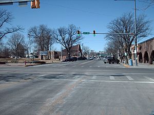
Main Street in Sterling.
|
|
| Nickname(s):
A Colorado Treasure
|
|
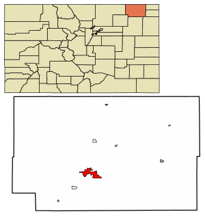
Location of the City of Sterling in Logan County, Colorado.
|
|
| Country | |
| State | |
| County | Logan County |
| City | Sterling |
| Settled | 1868 |
| Platted | 1890 |
| Incorporated | December 3, 1884 |
| Government | |
| • Type | Home rule municipality |
| Area | |
| • Total | 7.43 sq mi (19.25 km2) |
| • Land | 7.43 sq mi (19.25 km2) |
| • Water | 0.00 sq mi (0.00 km2) 0.0% |
| Elevation | 3,937 ft (1,181 m) |
| Population
(2020)
|
|
| • Total | 13,735 |
| • Density | 1,848.6/sq mi (713.51/km2) |
| Time zone | UTC−7 (MST) |
| • Summer (DST) | UTC−6 (MDT) |
| ZIP code |
80751
|
| Area code(s) | 970 |
| FIPS code | 08-73935 |
| GNIS feature ID | 0202901 |
| Website | City of Sterling |
Sterling is a special kind of town in Colorado called a "home rule municipality." This means it has its own local government that can make many decisions for the town. It's also the county seat of Logan County, Colorado, which means it's where the main government offices for the county are located. Sterling is the largest town in Logan County.
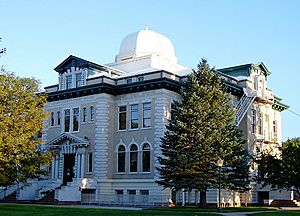
In 2020, about 13,735 people lived in Sterling. It's the biggest city in the eastern plains of Colorado. Sterling is also home to the Logan County Courthouse, a cool building with a dome that was built in 1909.
Contents
Discovering Sterling, Colorado
The History of Sterling
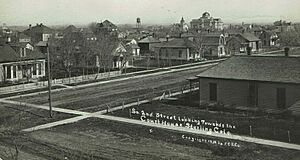
Sterling got its name from Sterling, Illinois, which was the hometown of a railroad official. A post office opened here in 1874. The town was officially started, or "incorporated," on December 3, 1884.
Where is Sterling Located?
Sterling is located in the northeastern part of Colorado, on the "eastern plains." It's about 128 miles (206 km) northeast of Denver. You can reach Sterling by taking Interstate 76.
The city covers an area of about 7.43 square miles (19.25 square kilometers), and all of it is land.
Sterling's Climate
Sterling has a semi-arid climate. This means it's generally dry, but not a desert. It gets some rain and snow throughout the year.
| Climate data for Sterling, Colorado (1981–2010) | |||||||||||||
|---|---|---|---|---|---|---|---|---|---|---|---|---|---|
| Month | Jan | Feb | Mar | Apr | May | Jun | Jul | Aug | Sep | Oct | Nov | Dec | Year |
| Mean daily maximum °F (°C) | 42 (6) |
46 (8) |
56 (13) |
64 (18) |
74 (23) |
84 (29) |
91 (33) |
89 (32) |
80 (27) |
67 (19) |
53 (12) |
42 (6) |
66 (19) |
| Mean daily minimum °F (°C) | 14 (−10) |
18 (−8) |
26 (−3) |
35 (2) |
46 (8) |
56 (13) |
61 (16) |
59 (15) |
48 (9) |
35 (2) |
24 (−4) |
15 (−9) |
36 (3) |
| Average precipitation inches (mm) | 0.30 (7.6) |
0.36 (9.1) |
0.96 (24) |
1.33 (34) |
2.31 (59) |
2.76 (70) |
2.66 (68) |
1.88 (48) |
1.18 (30) |
1.09 (28) |
0.54 (14) |
0.34 (8.6) |
15.72 (399) |
| Average snowfall inches (cm) | 4.0 (10) |
4.0 (10) |
3.7 (9.4) |
1.8 (4.6) |
0.0 (0.0) |
0.0 (0.0) |
0.0 (0.0) |
0.0 (0.0) |
0.4 (1.0) |
1.0 (2.5) |
4.1 (10) |
5.8 (15) |
24.8 (63) |
| Source: Weather.com | |||||||||||||
Who Lives in Sterling?
| Historical population | |||
|---|---|---|---|
| Census | Pop. | %± | |
| 1890 | 540 | — | |
| 1900 | 998 | 84.8% | |
| 1910 | 3,044 | 205.0% | |
| 1920 | 6,415 | 110.7% | |
| 1930 | 7,195 | 12.2% | |
| 1940 | 7,411 | 3.0% | |
| 1950 | 7,534 | 1.7% | |
| 1960 | 10,751 | 42.7% | |
| 1970 | 10,636 | −1.1% | |
| 1980 | 11,385 | 7.0% | |
| 1990 | 10,362 | −9.0% | |
| 2000 | 11,360 | 9.6% | |
| 2010 | 14,777 | 30.1% | |
| 2020 | 13,735 | −7.1% | |
| U.S. Decennial Census | |||
In 2020, there were about 13,753 people living in Sterling. These people lived in 4,604 households, and 2,790 of those were families.
Most people in Sterling are of European descent (90.75%). There are also people from many other backgrounds, including African American, Native American, Asian, and Pacific Islander. About 14.20% of the population is Hispanic or Latino.
About 30.6% of households had children under 18. The average household had 2.34 people, and the average family had 3.03 people.
The population is spread out by age:
- 25.5% are under 18 years old.
- 12.9% are between 18 and 24.
- 25.5% are between 25 and 44.
- 19.6% are between 45 and 64.
- 16.4% are 65 years or older.
The average age in Sterling is 35 years.
Sterling's Economy and Jobs
Sterling is an important place for jobs in northeastern Colorado. Some of the biggest employers include:
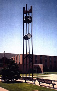
- Northeastern Junior College
- The RE-1 Valley School system
- The Sterling Correctional Facility (a prison)
Sterling is also the main shopping area for many towns in northeastern Colorado. You can find large chain stores and many local shops, especially on Main Street. The town has several banks, local radio stations (AM and FM), a local TV station, and a newspaper called the Sterling Journal-Advocate and South Platte Sentinel [1].
Education in Sterling
Sterling is home to Northeastern Junior College, where students can get a two-year degree. The town also has the RE-1 Valley School District, which includes schools for younger students.
Getting Around Sterling
Transportation Options
Sterling has its own airport called Crosson Field, but it doesn't have regular commercial flights. If you want to fly, the closest major airport is Denver International Airport, about 121 miles (195 km) away.
Trains also serve Sterling, mainly for carrying goods (freight). The main train company is Burlington Northern Santa Fe (BNSF), and Union Pacific also operates here. If you want to take a passenger train, the closest Amtrak station is in Fort Morgan, Colorado, about 47 miles (76 km) away.
You can also travel by bus. Companies like Burlington Trailways and Express Arrow offer bus services to Denver and several cities in Nebraska, such as North Platte, Kearney, and Omaha. Sterling is also part of Colorado's Bustang network, which provides bus routes to Denver and Greeley a few days a week.
Major Highways in Sterling
Several important highways pass through or near Sterling:
 Interstate 76 connects Sterling to Denver (about 128 miles or 206 km southwest). It also goes northeast to Interstate 80 in Big Springs, Nebraska.
 Business Loop 76 is a local route that goes through Sterling's main streets, connecting to Atwood and Merino.
 US 6 is a very long highway that runs from east to west across the United States. It connects Sterling to many other states.
 US 138 runs next to Interstate 76 and connects Sterling to US 30 in Nebraska.
 State Highway 14 connects Sterling to Fort Collins, which is about 102 miles (164 km) to the west.
Media and Radio in Sterling
Sterling has its own local radio station:
- KSRX (97.5 FM), known as Bob FM, plays music from the "80's, 90's... and whatever!"
See also
 In Spanish: Sterling (Colorado) para niños
 | James B. Knighten |
 | Azellia White |
 | Willa Brown |


