
Greeley, Colorado facts for kids
Quick facts for kids
Greeley, Colorado
|
|
|---|---|

Weld County Courthouse in Greeley
|
|

Location of the City of Greeley in Weld County, Colorado
|
|

Greeley, Colorado
Location in Colorado

Greeley, Colorado
Location in the United States
|
|
| Country | |
| State | |
| County | Weld County seat |
| Founded | 1869 |
| Incorporated | November 15, 1885 |
| Named for | Horace Greeley |
| Area | |
| • Total | 49.092 sq mi (127.148 km2) |
| • Land | 48.933 sq mi (126.735 km2) |
| • Water | 0.159 sq mi (0.413 km2) |
| Elevation | 4,675 ft (1,425 m) |
| Population
(2020)
|
|
| • Total | 108,795 |
| • Rank | 10th in Colorado 286th in the United States |
| • Density | 2,223/sq mi (858/km2) |
| • Metro | 328,981 (156th) |
| • CSA | 3,623,560 (17th) |
| • Front Range | 5,055,344 |
| GDP | |
| • Metro | $27.334 billion (2022) |
| Time zone | UTC−07:00 (MST) |
| • Summer (DST) | UTC−06:00 (MDT) |
| ZIP Codes |
80631–80634 & 80638–80639
|
| Area code | 970 |
| FIPS code | 08-32155 |
| GNIS feature ID | 0180649 |
| Highways | US 34, US 85, SH 257, SH 263, SH 392 |
| Website | City of Greeley Colorado |
Greeley is a city in Colorado, United States. It is the main city of Weld County. Greeley is also the county seat, which means it is where the county government is located. In 2020, about 108,795 people lived there. This makes Greeley the tenth largest city in Colorado.
Greeley is known as a college town. It is home to the University of Northern Colorado and Aims Community College. The city is in northern Colorado, about 49 miles (79 km) north of Denver.
Contents
History of Greeley

Founding the Union Colony
Greeley started as the Union Colony of Colorado in 1869. It was founded by Nathan C. Meeker, a writer for the New York Tribune newspaper. Meeker wanted to create a special farming community. This community would focus on good values like family, education, and farming.
The idea was supported by Horace Greeley, the editor of the Tribune. Horace Greeley had visited Colorado before. He was famous for saying, "Go West, young man!"
A group, including Meeker, chose a spot for the colony. They bought 12,000 acres of land. This land was where the Cache la Poudre River and South Platte River meet. The location was also halfway between Cheyenne, Wyoming and Denver, Colorado. It was right along the Denver Pacific Railroad tracks.
By May 1869, about 500 people had moved to the new colony. The community was first called Union Colony. Later, its name was changed to Greeley to honor Horace Greeley.
Latham Station's Role
Greeley is located near an old station called Latham. This station was part of the Overland Trail, a famous route for travelers. Latham station was built in 1862. It was named after Milton Latham, an early senator from California.
The station was important for stagecoaches. It was also the county seat for a time.
Growth and Modern Times
Greeley officially became a city on April 6, 1886. The city grew based on farming and agriculture. However, it also quickly adopted new technologies. Telephones arrived in 1883, and electric lights lit up downtown by 1886. By 1910, cars were driving alongside horse-drawn buggies.
In 1922, KFKA became one of the first radio stations in the U.S. The Greeley Municipal Airport was built in 1928.
During World War II in 1943, Greeley had two prisoner of war camps. One camp held German prisoners, and the other held Italian prisoners.
In 1958, Greeley became the first city to have a Department of Culture. This department helps support arts and cultural events.
A big hailstorm hit the eastern part of Greeley on May 28, 2024. It caused a lot of damage and flooding. The mayor declared it a local disaster.

Greeley's Location and Environment
Greeley is in the High Plains area of northern Colorado. It is about 25 miles (40 km) east of the Rocky Mountains. The city is also north of Denver.
The towns of Evans and Garden City border Greeley to the south. The South Platte River forms the southern boundary of the Greeley/Evans area. The Cache la Poudre River flows through the northern part of Greeley. Major roads like US Route 85 and US Route 34 serve the city.
In 2020, Greeley covered about 49.1 square miles (127.148 km2). Only a small part of this area is water. The closest large city with over 100,000 people is Fort Collins.
Greeley's Climate
.jpg)
Greeley has a semi-arid climate. This means it is generally dry. Summers are warm, with temperatures usually around 90–95 °F (32–35 °C). Winters are cooler, with temperatures around 40–45 °F (4–7 °C). However, temperatures can change a lot.
The hottest days are usually in July, and the coldest in January. Nighttime temperatures are around 60 °F (16 °C) in summer. In winter, they drop to about 15–20 °F (−9 to −7 °C). Record temperatures have been as high as 112 °F (44.4 °C) and as low as –25 °F (–32 °C).
The first frost usually happens around October 4. The last frost is around May 4. Greeley does not get many big storm systems. This is because of its location near the Rocky Mountains. The city gets less rain and fewer thunderstorms than some nearby areas.
The climate in Colorado, including Greeley, is very dry. Warm winds called Chinook winds can make winter temperatures much warmer. They can reach near 70 °F (21 °C) in January and February. Sometimes, they even reach 90 °F (32 °C) in April.
Because of its elevation and low humidity, nighttime temperatures in Greeley are almost never above 68 °F (20 °C). This is true even in the hottest part of summer. The temperature can change a lot between day and night. A 50-degree Fahrenheit difference is common, especially in spring and fall. Temperatures can also change quickly from one day to the next.
| Climate data for Greeley, Colorado, 1991–2020 normals, extremes 1967–present | |||||||||||||
|---|---|---|---|---|---|---|---|---|---|---|---|---|---|
| Month | Jan | Feb | Mar | Apr | May | Jun | Jul | Aug | Sep | Oct | Nov | Dec | Year |
| Record high °F (°C) | 74 (23) |
78 (26) |
85 (29) |
91 (33) |
101 (38) |
110 (43) |
112 (44) |
106 (41) |
105 (41) |
91 (33) |
84 (29) |
76 (24) |
112 (44) |
| Mean maximum °F (°C) | 63 (17) |
67.2 (19.6) |
77.3 (25.2) |
83.9 (28.8) |
91.5 (33.1) |
99.1 (37.3) |
102 (39) |
98.9 (37.2) |
95.2 (35.1) |
86 (30) |
73.2 (22.9) |
62.7 (17.1) |
103.1 (39.5) |
| Mean daily maximum °F (°C) | 44.1 (6.7) |
47.7 (8.7) |
59.1 (15.1) |
66 (19) |
74.7 (23.7) |
85.8 (29.9) |
91.7 (33.2) |
89.2 (31.8) |
81.9 (27.7) |
67.8 (19.9) |
53.6 (12.0) |
43.4 (6.3) |
67.1 (19.5) |
| Daily mean °F (°C) | 30.8 (−0.7) |
33.9 (1.1) |
43.6 (6.4) |
50.7 (10.4) |
59.6 (15.3) |
69.7 (20.9) |
75.5 (24.2) |
73.3 (22.9) |
65.3 (18.5) |
52.2 (11.2) |
39.7 (4.3) |
30.6 (−0.8) |
52.1 (11.1) |
| Mean daily minimum °F (°C) | 17.5 (−8.1) |
20 (−7) |
28.1 (−2.2) |
35.3 (1.8) |
44.5 (6.9) |
53.6 (12.0) |
59.3 (15.2) |
57.3 (14.1) |
48.7 (9.3) |
36.6 (2.6) |
25.8 (−3.4) |
17.8 (−7.9) |
37.0 (2.8) |
| Mean minimum °F (°C) | −2.9 (−19.4) |
0.9 (−17.3) |
10.2 (−12.1) |
21.6 (−5.8) |
31.3 (−0.4) |
43.8 (6.6) |
52.2 (11.2) |
49.6 (9.8) |
35.8 (2.1) |
20 (−7) |
6.4 (−14.2) |
−1.2 (−18.4) |
−9.2 (−22.9) |
| Record low °F (°C) | −25 (−32) |
−20 (−29) |
−10 (−23) |
−3 (−19) |
21 (−6) |
34 (1) |
42 (6) |
41 (5) |
17 (−8) |
−2 (−19) |
−7 (−22) |
−24 (−31) |
−25 (−32) |
| Average precipitation inches (mm) | 0.45 (11) |
0.45 (11) |
0.91 (23) |
1.83 (46) |
2.65 (67) |
1.78 (45) |
1.61 (41) |
1.56 (40) |
1.13 (29) |
1.06 (27) |
0.67 (17) |
0.55 (14) |
14.65 (371) |
| Average snowfall inches (cm) | 5.7 (14) |
5.1 (13) |
5.1 (13) |
3.7 (9.4) |
0.5 (1.3) |
0 (0) |
0 (0) |
0 (0) |
0.5 (1.3) |
3.3 (8.4) |
5.4 (14) |
5.6 (14) |
34.9 (88.4) |
| Average precipitation days (≥ 0.01 in) | 3.7 | 4.2 | 5.1 | 7.6 | 10.8 | 8.1 | 7.3 | 7 | 6.2 | 5.6 | 4.3 | 3.6 | 73.5 |
| Average snowy days (≥ 0.1 in) | 3.2 | 3.4 | 2.5 | 2.1 | 0.2 | 0 | 0 | 0 | 0.3 | 1.1 | 2.8 | 3.4 | 19 |
| Source 1: NOAA | |||||||||||||
| Source 2: National Weather Service | |||||||||||||
People and Population
| Historical population | |||
|---|---|---|---|
| Census | Pop. | %± | |
| 1870 | 480 | — | |
| 1880 | 1,297 | 170.2% | |
| 1890 | 2,395 | 84.7% | |
| 1900 | 3,023 | 26.2% | |
| 1910 | 8,179 | 170.6% | |
| 1920 | 10,958 | 34.0% | |
| 1930 | 12,203 | 11.4% | |
| 1940 | 15,995 | 31.1% | |
| 1950 | 20,354 | 27.3% | |
| 1960 | 26,314 | 29.3% | |
| 1970 | 38,902 | 47.8% | |
| 1980 | 53,006 | 36.3% | |
| 1990 | 60,536 | 14.2% | |
| 2000 | 76,930 | 27.1% | |
| 2010 | 92,889 | 20.7% | |
| 2020 | 108,795 | 17.1% | |
| U.S. Decennial Census | |||

In 2020, Greeley had a population of 108,795 people. This was a big increase from 2010. The city continues to grow.
Population Details (2020 Census)
| Race / Ethnicity (NH = Non-Hispanic) | Pop 2000 | Pop 2010 | Pop 2020 | % 2000 | % 2010 | % 2020 |
|---|---|---|---|---|---|---|
| White alone (NH) | 51,404 | 55,090 | 55,803 | 66.82% | 59.31% | 51.29% |
| Black or African American alone (NH) | 564 | 1,295 | 2,725 | 0.73% | 1.39% | 2.50% |
| Native American or Alaska Native alone (NH) | 268 | 408 | 528 | 0.35% | 0.44% | 0.49% |
| Asian alone (NH) | 863 | 1,176 | 2,075 | 1.12% | 1.27% | 1.91% |
| Pacific Islander alone (NH) | 94 | 90 | 111 | 0.12% | 0.10% | 0.10% |
| Some Other Race alone (NH) | 100 | 141 | 414 | 0.13% | 0.15% | 0.38% |
| Mixed Race or Multi-Racial (NH) | 954 | 1,249 | 3,381 | 1.24% | 1.34% | 3.11% |
| Hispanic or Latino (any race) | 22,683 | 33,440 | 43,758 | 29.49% | 36.00% | 40.22% |
| Total | 76,930 | 92,889 | 108,795 | 100.00% | 100.00% | 100.00% |
In 2021, there were about 109,340 people living in Greeley. Around 28,458 residents were under 18 years old. The average age in Greeley was 31.7 years. There were slightly more females than males.
Most people in Greeley identified as White. About 43.8% of the population identified as Hispanic or Latino. Many different races and ethnic groups live in Greeley.
The city had about 38,381 households. Most of these were family households. About 12,578 families had children under 18 living with them.
The average income for a household was $64,853. For families, it was $75,477. The income per person in the city was $30,195. About 17.4% of the population had incomes below the poverty line.
Many adults in Greeley have finished high school. About 26% of adults aged 25 and over have a bachelor's degree or higher.
Greeley's Economy
Greeley is home to several important companies. These include JBS USA, a large meatpacking company. Another major company is Hensel Phelps Construction, a contractor. Atmos Energy also has operations in Greeley.
In 2010, Leprino Foods started building a large factory in Greeley. This factory was completed in 2017. It now employs about 500 people.
Major Employers in Greeley
Here are the largest employers in Greeley as of May 1, 2023:
| # | Employer | # of employees |
|---|---|---|
| 1 | JBS USA | 5,141 |
| 2 | Banner Health / North Colorado Medical Center | 4,558 |
| 3 | Greeley-Evans School District 6 | 2,258 |
| 4 | Weld County | 1,823 |
| 5 | University of Northern Colorado | 1,221 |
| 6 | City of Greeley | 1,145 |
| 7 | University of Colorado Health (All Weld) | 1,030 |
| 8 | State Farm | 857 |
| 9 | Aims Community College | 817 |
| 10 | North Range Behavioral Health | 560 |
Arts and Culture

In 2014, Greeley was recognized as an official Creative District. This means it's a special area that supports arts and culture.
The Greeley Independence Stampede is a famous summer event. It started in 1922 as the Greeley Spud Rodeo. This event lasts almost two weeks around the Independence Day holiday. It includes rodeos, carnival rides, food, and live music. There is also a big parade on the Fourth of July. About 250,000 people visit this event each year.
Union Colony Civic Center
Greeley has the Union Colony Civic Center. This is one of the biggest places for performing arts in Colorado. It has a large concert hall with 1,686 seats. Here, you can see Broadway shows, concerts, and comedians. Smaller local groups also perform there.
The center also has a smaller theater with 214 seats. This theater hosts plays, talks, and other performances. There is also an art gallery called the Tointon Gallery. It shows art from local and national artists, and it's free to visit.
The City of Greeley owns and runs the Union Colony Civic Center. It hosts many events for the University of Northern Colorado. It is also home to the Greeley Philharmonic Orchestra and the Greeley Chorale.
Education in Greeley

In 2021, there were about 20,442 children aged 5–18 in Greeley. Most of these children attend schools in the Greeley-Evans School District 6. This public school district has many schools:
- 2 preschool programs
- 11 elementary schools
- 6 K–8 schools (kindergarten through 8th grade)
- 4 middle schools (grades 6–8)
- 1 junior high school (grades 7–9)
- 3 traditional high schools
- 3 non-traditional high schools
- 1 K–12 online school
The school district also runs the Poudre Learning Center. This center teaches about the Cache la Poudre river. Many public schools offer special programs called magnet programs. These programs let students attend schools outside their neighborhood for unique learning experiences. For example, Greeley West High School has an International Baccalaureate program. Greeley Central High School has an arts program. Northridge High School focuses on science, technology, engineering, and math (STEM).
The district also works with six charter schools. These include University Schools and Frontier Academy. Some high schools also partner with Aims Community College or the University of Northern Colorado. This allows high school students to take college courses.
Greeley also has several private schools. These include St. Mary's Catholic School and Dayspring Christian School. Some students in Greeley are also home-schooled.
Colleges and Universities
Greeley is home to several colleges and universities:
- University of Northern Colorado: A public university with about 9,000 students.
- Aims Community College: A community college offering various programs.
- IBMC College
- The Academy of Natural Therapy
Transportation
Greeley-Evans Transit (GET) provides public transportation in Greeley. It operates seven local bus routes. Since 2020, GET also has a regional bus service called the Poudre Express. This bus connects Greeley to Fort Collins and Windsor. Express Arrow also runs buses to Denver and Buffalo, Wyoming.
Notable People from Greeley

Many interesting people have connections to Greeley:
- Dee Bradley Baker: A voice actor.
- Maycee Barber: A professional UFC fighter.
- Shane Carwin: A professional UFC fighter.
- Joanna Cameron: An actress known for The Secrets of Isis.
- Bill Daniels: A pioneer in the cable television industry.
- Greg Germann: An actor.
- Edward W. Hardy: A composer, violinist, and producer.
- James A. Michener: A famous novelist who attended the University of Northern Colorado.
- Amanda Peterson: An actress.
- Maggie Peterson: An actress and singer.
- Connie Willis: A science-fiction author.
Sister City
Greeley has a sister city relationship with Moriya, Japan. The two cities have a student exchange program. In odd-numbered years, Greeley sends high school students to visit Moriya. In even-numbered years, Greeley hosts students from Moriya. This program helps students learn about different cultures.
Images for kids
-
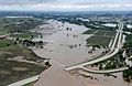
Flooding in Greeley in 2013
See also
 In Spanish: Greeley (Colorado) para niños
