
High Plains (United States) facts for kids
Quick facts for kids High Plains |
|
|---|---|

A buffalo wallow on the High Plains.
|
|

Physiographic regions of the United States. The High Plains region is the center yellow area designated 13d.
|
|
| Floor elevation | 1,800–7,000 ft (550–2,130 m) |
| Length | 800 mi (1,300 km) |
| Width | 400 mi (640 km) |
| Area | 174,000 sq mi (450,000 km2) |
| Geography | |
| Country | United States |


The High Plains are a large area of flat land in the Western United States. They are part of a bigger region called the Great Plains. You can find the High Plains in states like Montana, Wyoming, South Dakota, Nebraska, Colorado, Kansas, New Mexico, and Oklahoma and Texas.
This region is special because it gets higher in elevation as you go from east to west. It starts around 1,800 feet (550 meters) high and goes up to about 7,000 feet (2,100 meters) high. The southern part of the High Plains includes a unique landform called Llano Estacado. You can even see it from space!
Contents
What's in a Name?
For a long time, people called this whole area the "High Plains." This was to show it was different from the lower "Prairie Plains" further east.
Around the early 1900s, a new name, "Great Plains," became more common. Today, "High Plains" usually refers to just the western part of the larger Great Plains area.
Weather and Land
The High Plains have a "cold semi-arid" climate. This means it's often dry and cool. The region usually gets only about 10 to 20 inches (25 to 50 cm) of rain each year.
Because it's dry and high up, the High Plains can have big temperature changes. The temperature can drop by 30°F (16.5°C) from day to night. Once, in Browning, Montana, the temperature dropped an amazing 100°F (55.5°C) in just 24 hours! This happened in January 1916. That's a world record for the biggest temperature change in one day.
Strong winds often blow from the west across the High Plains. These winds can make winter feel even colder. Because of these strong winds, many wind farms are being built here to create electricity.
Scientists have a cool idea about why the High Plains are so high. They think that water trapped deep underground pushed the land up. This happened over a very long time.
Plants of the High Plains
The High Plains are home to tough plants that can handle the dry, windy conditions. You'll mostly see shortgrass prairie, which are grasses that don't grow very tall.
You might also spot prickly pear cacti and scrubby bushes. Closer to the Rocky Mountains, where it's even higher and drier, you can find sagebrush steppe.
How People Make a Living
Farming is a very important part of life in the High Plains. People raise cattle and grow crops like wheat, corn, and sunflower.
Since it's dry, farmers often use special methods to grow crops without much water. They also use irrigation, which means bringing water to the fields. Much of this water comes from a huge underground water source called the Ogallala Aquifer. This aquifer allows farmers to grow crops like corn, which need a lot of water.
The High Plains also have valuable natural resources. There are large amounts of petroleum (oil) and natural gas hidden underground. The combination of oil, gas, and wind energy, along with underground water, helps support many businesses in the region. For example, a metal factory in Amarillo, Texas has been running since 1924 because it has access to cheap natural gas and water.
People and Cities
The High Plains is one of the least crowded places in the United States. Wyoming, for example, has very few people living in it compared to its size.
While some smaller towns in the northern High Plains have seen their populations shrink, cities in west Texas are growing. Amarillo and Lubbock each have over 200,000 people and continue to get bigger.
Major Cities and Towns
- Alliance, Nebraska
- Amarillo, Texas
- Aurora, Colorado
- Benkelman, Nebraska
- Colby, Kansas
- Chadron, Nebraska
- Chappell, Nebraska
- Cheyenne, Wyoming
- Clovis, New Mexico
- Colorado Springs, Colorado
- Denver, Colorado
- Dodge City, Kansas
- Fort Morgan, Colorado
- Garden City, Kansas
- Goodland, Kansas
- Gering, Nebraska
- Grant, Nebraska
- Greeley, Colorado
- Guymon, Oklahoma
- Hays, Kansas
- Hobbs, New Mexico
- Imperial, Nebraska
- Kimball, Nebraska
- La Junta, Colorado
- Lamar, Colorado
- Liberal, Kansas
- Limon, Colorado
- Lubbock, Texas
- Midland, Texas
- Miles City, Montana
- Odessa, Texas
- Ogallala, Nebraska
- Pecos, Texas
- Pine Ridge, South Dakota
- Porcupine, South Dakota
- Portales, New Mexico
- Roswell, New Mexico
- Sidney, Nebraska
- Santa Rosa, New Mexico
- Scottsbluff, Nebraska
- Sterling, Colorado
- Torrington, Wyoming
- Tucumcari, New Mexico
- Ulysses, Kansas
- Vaughn, New Mexico
- Wheatland, Wyoming
- Willard, Colorado
Gallery
-
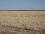
Cimarron County near Boise City. (2009)
-
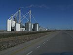
Grain silos, a common sight on the High Plains. (2009)
-
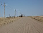
High Plains in Southeastern Colorado (2009)
-
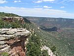
The High Plains are broken in places by canyons, such as this one in Sabinoso Wilderness in New Mexico.


.jpg)
See also
- Altiplano
- Dust storm
- Flora of the Great Plains (North America)
- Great American Desert
- List of ecoregions in the United States (EPA)
- Llano Estacado
- North American Prairies Province
- Shortgrass prairie
- Steppe
- Temperate grasslands, savannas, and shrublands—Biome
- Texas High Plains AVA, wine region in the Texas section of the High Plains
- Tibetan Plateau
- Western short grasslands
- Wind power in Texas
