
Cimarron County, Oklahoma facts for kids
Quick facts for kids
Cimarron County
|
|
|---|---|

Cimarron County Courthouse in Boise City (2009)
|
|

Location within the U.S. state of Oklahoma
|
|
 Oklahoma's location within the U.S. |
|
| Country | |
| State | |
| Founded | 1907 |
| Seat | Boise City |
| Largest city | Boise City |
| Area | |
| • Total | 1,841 sq mi (4,770 km2) |
| • Land | 1,835 sq mi (4,750 km2) |
| • Water | 6.1 sq mi (16 km2) 0.3%% |
| Population
(2020)
|
|
| • Total | 2,296 |
| • Density | 1.2/sq mi (0.5/km2) |
| Time zones | |
| entire county (legally) | UTC−6 (Central) |
| • Summer (DST) | UTC−5 (CDT) |
| Kenton (unofficially) | UTC−7 (Mountain) |
| • Summer (DST) | UTC−6 (MDT) |
Cimarron County is the county farthest west in the state of Oklahoma. Its main town and government center is Boise City. In 2020, about 2,296 people lived here. This makes it the county with the fewest people in Oklahoma. It has almost always been the least populated and least crowded county in the state.
Cimarron County is part of the Oklahoma Panhandle. It is home to Kenton, the only place in Oklahoma that uses the Mountain Time Zone. The highest point in Oklahoma, Black Mesa, is in the northwest part of the county. Cimarron County also has some interesting weather facts. The town of Regnier gets the least rain in Oklahoma, with only about 15.62 inches per year. But Boise City gets the most snow, with about 31.6 inches each year!
Contents
Discovering Cimarron County's Past
Cimarron County was created in 1907 when Oklahoma became a state. Before 1890, this area was known as "No-Man's Land." It was also called the "Public Land Strip." This was a wild area with no official government. Many outlaws hid there.
In 1890, the strip became part of Beaver County, Oklahoma Territory. People often called it the "Oklahoma Panhandle." Only two small towns existed then: Carrizo (near Kenton) and Mineral City. Most of the land was used by sheep herders from New Mexico.
Choosing a County Seat
After Oklahoma became a state, several towns wanted to be the county seat. These included Boise City, Cimarron, Doby, Hurley, Willowbar, and Centerview. In 1908, the people voted, and Boise City was chosen.
Railroads and the Dust Bowl
Railroads came late to Cimarron County. The Elkhart and Santa Fe Railway built a line through the county in 1925. It connected to New Mexico in 1932. This service stopped in 1942. Another line was built from Colorado to Boise City in 1931. It went into Texas by 1937. This line is still used today by BNSF.
Cimarron County was hit hard by the Dust Bowl in the 1930s. This was a time when severe dust storms damaged farms. A famous photo from 1936, Farmer and Sons Walking in the Face of a Dust Storm, was taken here.
Exploring Cimarron County's Landscape

The U.S. Census Bureau says the county covers about 1,841 square miles. Most of this (1,835 square miles) is land. Only a small part (6.1 square miles) is water. Cimarron County is the fourth-largest county in Oklahoma by land area.
It also has Oklahoma's highest point, Black Mesa, which is 4,973 feet above sea level. The northern part of the county has the Cimarron River. It flows east and then north into Kansas. The southern part has the Beaver River, also called the North Canadian River. Lake Carl Etling, made by people, is inside Black Mesa Park.
The Boise City Airport is about 3 miles north of Boise City.
Main Roads in Cimarron County
 U.S. Highway 56
 U.S. Highway 64
 U.S. Highway 287
 U.S. Highway 385
 U.S. Highway 412
 State Highway 3
 State Highway 171
 State Highway 325
Neighboring States and Counties
Cimarron County is special because it is the only county in the United States that touches four other states: Colorado, Kansas, New Mexico, and Texas. This means it borders counties from five different states!
- Baca County, Colorado (north)
- Morton County, Kansas (northeast)
- Texas County (east)
- Dallam County, Texas (south)
- Sherman County, Texas (southeast)
- Union County, New Mexico (west)
There's a spot in Cimarron County that is less than 27 miles from five different states. It's about 26.99 miles from Kansas, New Mexico, and Texas, and only 7 miles from Colorado.
Protected Natural Areas
Part of the Rita Blanca National Grassland is located in Cimarron County. This is a protected area of grasslands.
People of Cimarron County
| Historical population | |||
|---|---|---|---|
| Census | Pop. | %± | |
| 1910 | 4,553 | — | |
| 1920 | 3,436 | −24.5% | |
| 1930 | 5,408 | 57.4% | |
| 1940 | 3,054 | −43.5% | |
| 1950 | 4,589 | 50.3% | |
| 1960 | 4,496 | −2.0% | |
| 1970 | 4,145 | −7.8% | |
| 1980 | 3,648 | −12.0% | |
| 1990 | 3,301 | −9.5% | |
| 2000 | 3,148 | −4.6% | |
| 2010 | 2,475 | −21.4% | |
| 2020 | 2,296 | −7.2% | |
| U.S. Decennial Census 1790-1960 1900-1990 1990-2000 2010-2019 |
|||
In 2010, there were 2,475 people living in Cimarron County. There were 1,047 households and 705 families. The county had about 2 people per square mile. Most people (84.7%) were White. About 12.1% were from other races. About 20.8% of the people were Hispanic or Latino.
About 31.3% of households had children under 18. Most households (60.4%) were married couples. The average household had 2.47 people. The average family had 3.07 people.
The median age in the county was 39 years old. About 27.6% of the people were under 18. About 18.6% were 65 or older.
The median income for a household was $30,625. For a family, it was $36,250. About 17.6% of the people lived below the poverty line. This included 22.2% of those under 18.
Cimarron County's Economy
For a long time, the economy of Cimarron County has been based on raising cattle and farming. Wheat and grain sorghum are the most important crops grown here. The Dust Bowl in the 1930s caused huge problems for the county's economy. Then, heavy rains from 1942-1945 destroyed what was left. The economy had to be completely rebuilt.
In the 1960s, finding oil and natural gas became important. A gas plant near Keyes started making helium in 1959. By 2000, Cimarron County had the ninth-highest income per person among all Oklahoma counties.
Towns and Communities
City
- Boise City (This is the county seat, where the main government offices are.)
Towns
Census-Designated Places
These are areas that are like towns but are not officially incorporated.
Other Small Communities
These are smaller, unincorporated places.
Images for kids
-
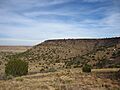
Black Mesa, the highest point in Oklahoma, is in the northwestern corner of Cimarron County.
-
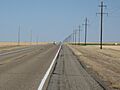
U.S. Route 412 in Cimarron County.
-
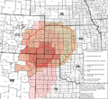
Area affected by 1930s Dust Bowl.
-
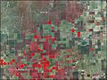
NASA satellite image of Cimarron County, August 2008.


.svg)

See also
 In Spanish: Condado de Cimarrón para niños
