
Morton County, Kansas facts for kids
Quick facts for kids
Morton County
|
|
|---|---|

Morton County Courthouse in Elkhart (2009)
|
|

Location within the U.S. state of Kansas
|
|
 Kansas's location within the U.S. |
|
| Country | |
| State | |
| Founded | February 20, 1886 |
| Named for | Oliver Morton |
| Seat | Elkhart |
| Largest city | Elkhart |
| Area | |
| • Total | 730 sq mi (1,900 km2) |
| • Land | 730 sq mi (1,900 km2) |
| • Water | 0.2 sq mi (0.5 km2) 0.03%% |
| Population
(2020)
|
|
| • Total | 2,701 |
| • Density | 3.7/sq mi (1.4/km2) |
| Time zone | UTC−6 (Central) |
| • Summer (DST) | UTC−5 (CDT) |
| Area code | 620 |
| Congressional district | 1st |
Morton County is a special area called a county in the very southwest part of Kansas. The main town and biggest city in Morton County is Elkhart. In 2020, about 2,701 people lived here. The county got its name from Oliver Morton, who was the 14th governor of Indiana.
Contents
History of Morton County
How Morton County Began
For thousands of years, the wide-open Great Plains of North America were home to nomadic Native American tribes. This means they moved around a lot instead of staying in one place.
From the 1500s to the 1700s, France said they owned big parts of North America. But in 1762, after a war, France secretly gave a huge area called New France to Spain. This was part of a deal called the Treaty of Fontainebleau.
The 1800s in Morton County
In 1802, Spain gave most of this land back to France. Then, in 1803, the United States bought a huge amount of land from France. This was called the Louisiana Purchase. It included most of what is now Kansas. The U.S. paid a very small amount for each acre!
Later, in 1848, after the Mexican–American War, the U.S. gained even more land. This new land, from a deal with Mexico called the Treaty of Guadalupe Hidalgo, included the southwest part of Kansas.
From 1821 to the late 1860s, a famous path called the Santa Fe Trail went right through Morton County. This trail was used for trade and travel.
In 1854, the area became the Kansas Territory. Then, in 1861, Kansas officially became the 34th U.S. state. Morton County itself was created in 1886. It was named after Oliver Morton, who was a United States senator from Indiana. At first, the town of Richfield was chosen as the county seat. This is the main town where the county government is located.
The 1900s in Morton County
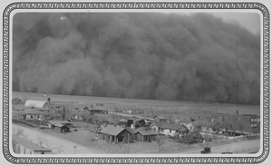
.svg)
In the 1930s, Morton County faced a huge challenge. It was right in the middle of the Dust Bowl. This was a time when severe droughts and strong winds caused massive dust storms. These storms blew away the topsoil, making it very hard for farmers. This disaster made the Great Depression even worse for the people living there.
Morton County was one of the hardest-hit areas in the Dust Bowl. Almost half of its people moved away during the 1930s. The U.S. government bought some of the damaged land. This land later became part of the Comanche National Grassland.
In 1961, the county seat was moved from Richfield to Elkhart.
Geography of Morton County
Morton County covers about 730 square miles (1,900 km2). Almost all of this area is land, with only a tiny bit of water.
A special spot in the county is the 8 Mile Corner. This is where Kansas, Colorado, and Oklahoma all meet!
Main Roads
Here are the main roads that go through Morton County:
 Kansas Highway 27
 Kansas Highway 51
 U.S. Highway 56
Neighboring Counties
Morton County shares borders with these other counties:
- Stanton County (to the north)
- Stevens County (to the east)
- Texas County, Oklahoma (to the south)
- Cimarron County, Oklahoma (to the southwest)
- Baca County, Colorado (to the west, this border is also where the time zone changes!)
Protected Areas
Part of the Cimarron National Grassland is located in Morton County. This is a large area of protected grasslands.
People of Morton County

| Historical population | |||
|---|---|---|---|
| Census | Pop. | %± | |
| 1890 | 724 | — | |
| 1900 | 304 | −58.0% | |
| 1910 | 1,333 | 338.5% | |
| 1920 | 3,177 | 138.3% | |
| 1930 | 4,092 | 28.8% | |
| 1940 | 2,186 | −46.6% | |
| 1950 | 2,610 | 19.4% | |
| 1960 | 3,354 | 28.5% | |
| 1970 | 3,576 | 6.6% | |
| 1980 | 3,454 | −3.4% | |
| 1990 | 3,480 | 0.8% | |
| 2000 | 3,496 | 0.5% | |
| 2010 | 3,233 | −7.5% | |
| 2020 | 2,701 | −16.5% | |
| 2023 (est.) | 2,580 | −20.2% | |
| U.S. Decennial Census 1790-1960 1900-1990 1990-2000 2010-2020 |
|||
In 2000, there were about 3,496 people living in Morton County. Most of the people were White, but there were also people from other backgrounds, including Native American, Asian, and African American. About 14% of the population was Hispanic or Latino.
Many households in Morton County had children under 18 living with them. The average household had about 2.6 people.
The median age in the county was 36 years old. This means half the people were younger than 36 and half were older.
Education in Morton County
School Districts
Students in Morton County go to schools run by these unified school districts:
- Rolla USD 217
- Elkhart USD 218
Communities in Morton County

Morton County has different types of communities, including cities and smaller, unincorporated areas.
Cities
Unincorporated Community
An unincorporated community is a place where people live together, but it doesn't have its own local government like a city does.
Townships
Morton County is divided into six smaller areas called townships. The populations of the cities are included in the township numbers.
| Township | FIPS | Population center |
Population | Population density /km2 (/sq mi) |
Land area km2 (sq mi) |
Water area km2 (sq mi) |
Water % | Geographic coordinates |
|---|---|---|---|---|---|---|---|---|
| Cimarron | 13350 | 67 | 0 (1) | 173 (67) | 0 (0) | 0% | 37°4′11″N 101°46′45″W / 37.06972°N 101.77917°W | |
| Jones | 35650 | 17 | 0 (0) | 140 (54) | 0 (0) | 0% | 37°1′4″N 101°56′56″W / 37.01778°N 101.94889°W | |
| Richfield | 59225 | 218 | 0 (1) | 649 (251) | 0 (0) | 0% | 37°14′37″N 101°42′36″W / 37.24361°N 101.71000°W | |
| Rolla | 60925 | Rolla | 650 | 2 (5) | 373 (144) | 0 (0) | 0% | 37°6′46″N 101°37′42″W / 37.11278°N 101.62833°W |
| Taloga | 69975 | Elkhart | 2,437 | 17 (44) | 142 (55) | 0 (0) | 0% | 37°0′22″N 101°53′42″W / 37.00611°N 101.89500°W |
| Westola | 77225 | 107 | 0 (1) | 412 (159) | 0 (0) | 0.01% | 37°14′19″N 101°58′40″W / 37.23861°N 101.97778°W |
See also
 In Spanish: Condado de Morton (Kansas) para niños
