Wilburton, Kansas facts for kids
Quick facts for kids
Wilburton, Kansas
|
|
|---|---|

|
|
| Country | United States |
| State | Kansas |
| County | Morton |
| Elevation | 3,435 ft (1,047 m) |
| Time zone | UTC-6 (CST) |
| • Summer (DST) | UTC-5 (CDT) |
| Area code | 620 |
| FIPS code | 20-79125 |
| GNIS ID | 484535 |
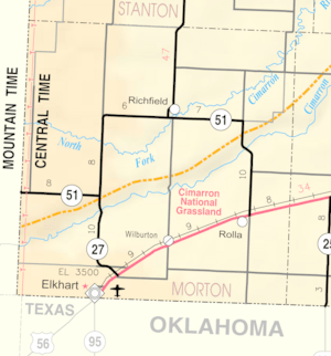
Wilburton is a small, unincorporated community in Morton County, Kansas. An unincorporated community means it's a group of homes and businesses that isn't officially a town or city with its own local government. Wilburton is located in the United States, in the state of Kansas.
You can find Wilburton along U.S. Route 56, which is a major highway. It's also near the Cimarron Valley Railroad. Wilburton is about 9 miles (14 km) northeast of a town called Elkhart.
Contents
Wilburton's Story: A Kansas Community
The area that is now Kansas became a territory in 1854. Later, in 1861, Kansas officially joined the United States as the 34th state. Years later, in 1886, Morton County was created. This new county included the land where Wilburton would eventually be built.
Early Days and Growth
Wilburton started to grow in the early 1900s. A post office, which is where mail is sent and received, opened in Wilburton in 1913. This was an important step for the community. The post office stayed open for many years, until 1957.
By the 1930s, Wilburton was a busy place. It had a population of about 1,000 to 1,500 people. The community had many useful businesses. There was a grocery store for food and a dry goods store for clothes and other items. People could also find a gas station, a repair garage for cars, and a restaurant.
Wilburton also had a complete system of public schools. This meant children could get an education right in their community. Several churches were also part of the town. For businesses, there were grain elevators, which store grain, and a lumber yard. A railroad station made it easy to transport goods and people.
Facing Hard Times: The Dust Bowl
However, the 1930s brought very difficult times for Wilburton. The community was located in an area known as the Dust Bowl. This was a period when severe dust storms hit the Great Plains region of the United States. Years of drought, meaning very little rain, combined with farming practices that removed natural grasses, led to the soil turning into dust. Strong winds then picked up this dust, creating massive, dark dust storms.
The Dust Bowl made life very hard for farmers and everyone in Wilburton. It also made the Great Depression even worse for the area. The Great Depression was a time of severe economic hardship across the world. Many people lost their jobs and homes. For Wilburton, the Dust Bowl added to these problems, making it tough for businesses and families to survive.
Wilburton's Decline
Despite these challenges, Wilburton managed to keep going until the mid-1950s. But after 1960, the community started to decline very quickly. It was no longer an official town by the start of that decade.
By the 1970s, most of the businesses and services in Wilburton were gone. The grocery store, gas station, and schools closed down. As the 21st century began, many of the homes were also gone or abandoned. Today, only a few buildings remain. There is one house near Route 56 and two farms on a side road across the railroad tracks. Some people even call Wilburton a "ghost town" because so little of it is left. Any unused buildings have been torn down or moved away.
 | Kyle Baker |
 | Joseph Yoakum |
 | Laura Wheeler Waring |
 | Henry Ossawa Tanner |


