
U.S. Route 56 facts for kids
Quick facts for kids
|
|
|---|---|
 |
|
| Route information | |
| Length | 640 mi (1,030 km) |
| Existed | 1957–present |
| Major junctions | |
| West end | |
|
|
| East end | |
| Location | |
| States: | New Mexico, Texas, Oklahoma, Kansas, Missouri |
| Highway system | |
| United States Numbered Highways List • Bannered • Divided • Replaced |
|

U.S. Route 56, often called US 56, is a long road that stretches across the middle of the United States. It runs from Springer, New Mexico in the west all the way to Kansas City, Missouri in the east. This highway is about 640 miles (1,030 kilometers) long. A big part of US 56 follows the path of the famous Santa Fe Trail, which was an important route for trade and travel many years ago.
Exploring U.S. Route 56
US 56 travels through several states, showing off different parts of the country. It starts in New Mexico and then goes through Oklahoma, Kansas, and Missouri.
A Quick Stop in Texas
Interestingly, US 56 also touches a tiny corner of Texas. This happens at a small road connection near the border between New Mexico and Oklahoma. It's just a small part of the route, but it means the highway technically passes through five states!
Images for kids
-
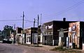
Scranton, Kansas on US 56, in 1974

