
Stevens County, Kansas facts for kids
Quick facts for kids
Stevens County
|
|
|---|---|

Stevens County Courthouse in Hugoton (2009)
|
|

Location within the U.S. state of Kansas
|
|
 Kansas's location within the U.S. |
|
| Country | |
| State | |
| Founded | August 3, 1886 |
| Named for | Thaddeus Stevens |
| Seat | Hugoton |
| Largest city | Hugoton |
| Area | |
| • Total | 727 sq mi (1,880 km2) |
| • Land | 727 sq mi (1,880 km2) |
| • Water | 0.2 sq mi (0.5 km2) 0.02% |
| Population
(2020)
|
|
| • Total | 5,250 |
| • Density | 7.2/sq mi (2.8/km2) |
| Time zone | UTC−6 (Central) |
| • Summer (DST) | UTC−5 (CDT) |
| Area code | 620 |
| Congressional district | 1st |
Stevens County is a county located in the U.S. state of Kansas. Its main town, called the county seat, is Hugoton. In 2020, about 5,250 people lived in the county. The county is named after Thaddeus Stevens, who was an important politician from Pennsylvania during a time called the Reconstruction era.
Contents
History of Stevens County
Stevens County was officially created in 1886. The very first settlers arrived in 1885 from McPherson, Kansas. They first named their town Hugo, after a famous writer, but later changed it to Hugoton. Other early towns included Lafayette, started by a group called Quakers in 1886, and Moscow, which began in 1887.
The County Seat War
In the late 1880s, there was a big disagreement known as the "county seat war". This was a fight over which town would be the permanent county seat. Hugoton was chosen as the temporary county seat, but another town, Woodsdale, also wanted the title. This conflict led to many tense situations.
The dispute became very serious. It even included arrests and kidnappings. The conflict reached a peak on July 25, 1888. This event is known as the Hay Meadow Massacre. The sheriff from Woodsdale and three of his men were killed. The person responsible for the killings was from Hugoton and was never brought to trial. Hugoton eventually became the permanent county seat in 1887. Even after this, feelings remained strong for several years.
Natural Gas and the Dust Bowl
In 1927, people discovered natural gas in Stevens County. This led to the creation of the Hugoton Natural Gas Area. Hugoton quickly became a major center for the natural gas industry. This discovery brought new jobs and growth to the area.
However, the 1930s brought tough times. Stevens County was part of the Dust Bowl. This was a period when severe dust storms damaged farms. The Dust Bowl made the economic problems of the Great Depression even worse for the region.
Geography of Stevens County
Stevens County covers a total area of about 727 square miles. Almost all of this area is land. Only a tiny part, about 0.2 square miles, is water.
Main Roads
 Kansas Highway 25
 Kansas Highway 51
 U.S. Highway 56
Neighboring Counties
Stevens County shares borders with several other counties:
- Grant County (to the north)
- Haskell County (to the northeast)
- Seward County (to the east)
- Texas County, Oklahoma (to the south)
- Morton County (to the west)
- Stanton County (to the northwest)
Protected Areas
A part of the Cimarron National Grassland is located in Stevens County. This is a special area managed for conservation.
People of Stevens County

| Historical population | |||
|---|---|---|---|
| Census | Pop. | %± | |
| 1880 | 12 | — | |
| 1890 | 1,418 | 11,716.7% | |
| 1900 | 620 | −56.3% | |
| 1910 | 2,453 | 295.6% | |
| 1920 | 3,943 | 60.7% | |
| 1930 | 4,655 | 18.1% | |
| 1940 | 3,193 | −31.4% | |
| 1950 | 4,516 | 41.4% | |
| 1960 | 4,400 | −2.6% | |
| 1970 | 4,198 | −4.6% | |
| 1980 | 4,736 | 12.8% | |
| 1990 | 5,048 | 6.6% | |
| 2000 | 5,463 | 8.2% | |
| 2010 | 5,724 | 4.8% | |
| 2020 | 5,250 | −8.3% | |
| 2023 (est.) | 5,077 | −11.3% | |
| U.S. Decennial Census 1790-1960 1900-1990 1990-2000 2010-2020 |
|||
In 2000, there were 5,463 people living in Stevens County. Most people were White, but there were also people of Black, Native American, and Asian backgrounds. A significant number of residents were of Hispanic or Latino heritage.
About 31% of the population was under 18 years old. The median age was 34 years. This means half the people were younger than 34 and half were older.
Education in Stevens County
Students in Stevens County attend schools in two main districts. These are called Unified School Districts.
School Districts
- Moscow USD 209
- Hugoton USD 210
Communities in Stevens County

Stevens County has several towns and communities.
Cities
Ghost Towns
These are towns that used to exist but are now abandoned.
- Feterita
- Woodsdale
Images for kids
-
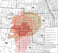
This map shows the areas affected by the Dust Bowl in the 1930s.
.svg)
See also
 In Spanish: Condado de Stevens (Kansas) para niños
