
Seward County, Kansas facts for kids
Quick facts for kids
Seward County
|
|
|---|---|

Seward County Courthouse in Liberal (2010)
|
|

Location within the U.S. state of Kansas
|
|
 Kansas's location within the U.S. |
|
| Country | |
| State | |
| Founded | March 20, 1873 |
| Named for | William H. Seward |
| Seat | Liberal |
| Largest city | Liberal |
| Area | |
| • Total | 640 sq mi (1,700 km2) |
| • Land | 639 sq mi (1,660 km2) |
| • Water | 1.0 sq mi (3 km2) 0.2% |
| Population
(2020)
|
|
| • Total | 21,964 |
| • Density | 34.4/sq mi (13.3/km2) |
| Time zone | UTC−6 (Central) |
| • Summer (DST) | UTC−5 (CDT) |
| Area code | 620 |
| Congressional district | 1st |
Seward County is a county in the state of Kansas, USA. Its main city and government center is Liberal. In 2020, about 21,964 people lived here. The county was created on March 20, 1873. It was named after William Seward, an important politician who worked with Presidents Abraham Lincoln and Andrew Johnson.
Contents
History of Seward County
For thousands of years, the wide-open Great Plains of North America were home to nomadic Native American groups. They moved from place to place, following animal herds and seasons.
In 1854, the area became the Kansas Territory. Then, in 1861, Kansas officially joined the United States as the 34th U.S. state.
How Seward County Was Formed
Seward County was set up in 1873. For a while, other nearby counties helped manage it. On June 10, 1885, Finney County officially organized Seward County as a part of its own area. They chose Sunset City as a temporary government center.
There was a big competition between two towns, Fargo Springs and Springfield, to become the county seat (the main city where the government offices are). This rivalry was so strong that people from each town tried to stop voters from the other town from reaching the polls during an election in 1885!
The argument over the county seat finally ended when new railroads were built. These railroads went through the southern part of Seward County, which helped the town of Liberal grow very quickly. Liberal won the final election for the county seat on December 8, 1892, by 125 votes.
The Dust Bowl Years
In the 1930s, the area faced a very tough time known as the Dust Bowl. This was a period when severe droughts and strong winds caused huge dust storms. These storms blew away the topsoil, making it very hard to farm. This natural disaster made the economic problems of the Great Depression even worse for the people living in Seward County.
Geography of Seward County
Seward County covers about 640 square miles (1,658 square kilometers). Most of this area is land, with only a small part being water. The county shares its southern border with the state of Oklahoma.
Neighboring Counties
Seward County is surrounded by several other counties:
- Haskell County (to the north)
- Meade County (to the east)
- Beaver County, Oklahoma (to the southeast)
- Texas County, Oklahoma (to the southwest)
- Stevens County (to the west)
People of Seward County (Demographics)

| Historical population | |||
|---|---|---|---|
| Census | Pop. | %± | |
| 1880 | 5 | — | |
| 1890 | 1,503 | 29,960.0% | |
| 1900 | 822 | −45.3% | |
| 1910 | 4,091 | 397.7% | |
| 1920 | 6,220 | 52.0% | |
| 1930 | 8,075 | 29.8% | |
| 1940 | 6,540 | −19.0% | |
| 1950 | 9,972 | 52.5% | |
| 1960 | 15,930 | 59.7% | |
| 1970 | 15,744 | −1.2% | |
| 1980 | 17,071 | 8.4% | |
| 1990 | 18,743 | 9.8% | |
| 2000 | 22,510 | 20.1% | |
| 2010 | 22,952 | 2.0% | |
| 2020 | 21,964 | −4.3% | |
| 2023 (est.) | 21,067 | −8.2% | |
| U.S. Decennial Census 1790-1960 1900-1990 1990-2000 2010-2020 |
|||
The city of Liberal and all of Seward County make up the Liberal, KS Micropolitan Statistical Area. This means it's a smaller city area with strong economic ties.
In 2000, there were 22,510 people living in the county. The population density was about 35 people per square mile. About 65% of the people were White, and about 42% were Hispanic or Latino.
Many households had children under 18 living with them (43.5%). The average household had about 3 people. The population was quite young, with 32% of people being under 18 years old. The average age in the county was 29 years.
Education in Seward County
Seward County has two main school districts that serve its communities:
- Liberal USD 480
- Kismet-Plains USD 483
Communities in Seward County

Here are the different types of communities you can find in Seward County:
Cities
Unincorporated Communities
These are smaller communities that are not officially organized as cities:
Ghost Towns
These are former communities that are now mostly deserted:
Images for kids
-
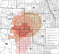
This map shows the areas affected by the Dust Bowl in the 1930s.
.svg)
See also
 In Spanish: Condado de Seward (Kansas) para niños
