Finney County, Kansas facts for kids
Quick facts for kids
Finney County
|
|
|---|---|

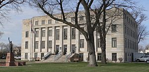
Finney County Courthouse in Garden City (2015)
|
|

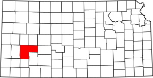
Location within the U.S. state of Kansas
|
|
 Kansas's location within the U.S. |
|
| Country | |
| State | |
| Founded | February 22, 1883 |
| Named for | David W. Finney |
| Seat | Garden City |
| Largest city | Garden City |
| Area | |
| • Total | 1,303 sq mi (3,370 km2) |
| • Land | 1,302 sq mi (3,370 km2) |
| • Water | 0.7 sq mi (2 km2) 0.05%% |
| Population
(2020)
|
|
| • Total | 38,470 |
| • Density | 29.5/sq mi (11.4/km2) |
| Time zone | UTC−6 (Central) |
| • Summer (DST) | UTC−5 (CDT) |
| Congressional district | 1st |
Finney County is a county in the state of Kansas. It's like a special area within the state. The main city and where the county government is located is Garden City. In 2020, about 38,470 people lived here. The county was named after David Wesley Finney, who was the Lieutenant Governor of Kansas from 1881 to 1885. In 2020, more than half of the people in Finney County were Hispanic. This makes it one of the few counties in Kansas with a Hispanic majority.
Contents
History
How Finney County Started
Finney County was first set up in 1867. It was named after Lieutenant Governor David Finney. The first white settlers came to the area in 1878. They built their homes near the Arkansas River.
Around 1880, Finney County was actually two different counties. They were called Buffalo County and Sequoyah County. Sequoyah County was named after Sequoyah, a Cherokee Indian. He created the Cherokee alphabet. Later, these two counties joined together. They were renamed Finney County to honor David Finney. The county grew to its current size in 1893. This happened when Garfield County became part of it.
Growing Up in Finney County
The town of Garden City began in 1879. It was started by a cattle company. They used it as a place to ship cattle. These cattle were driven along the Jones & Plummer Trail. Garden City grew quickly when railroads arrived in 1888. The Atchison, Topeka & Santa Fe and Chicago, Rock Island & Pacific railroads helped it become a busy hub.
In its early days, Garden City was a lively frontier town. It had places for gambling and dancing. But it soon became a big farming center. It was important for southwest Kansas.
Other towns like Holcomb, Kalvesta, and Pierceville also started in the 1880s. Finney County became a rich area for growing wheat and raising cattle. The number of people living in the county grew a lot. It went from only 537 people in 1880 to over 5,000 by 1890. Many new settlers moved in.
In 1893, the old Garfield County joined Finney County. It became known as Garfield Township. Garfield County had been created in 1887. But it had trouble getting enough people and money. By 1910, Finney County had over 10,000 people. Farming became very important in the area.
Geography
Where is Finney County?
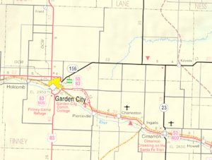
Finney County is a large area of land. It covers about 1,303 square miles. Most of this is land, about 1,302 square miles. Only a tiny bit, 0.7 square miles, is water. This means water makes up only 0.05% of the county. Finney County is the second-largest county in Kansas by size.
Neighboring Counties
Finney County shares its borders with several other counties:
- Scott County (north)
- Lane County (north)
- Ness County (northeast)
- Hodgeman County (east)
- Haskell County (south)
- Gray County (south)
- Grant County (southwest)
- Kearny County (west)
Who Lives Here?

Finney County is part of the Garden City, KS Micropolitan Statistical Area. This means it's a smaller city area that is important for its region.
Population Changes Over Time
The number of people living in Finney County has changed a lot over the years.
| Historical population | |||
|---|---|---|---|
| Census | Pop. | %± | |
| 1890 | 4,231 | — | |
| 1900 | 3,469 | −18.0% | |
| 1910 | 6,908 | 99.1% | |
| 1920 | 7,674 | 11.1% | |
| 1930 | 11,014 | 43.5% | |
| 1940 | 10,092 | −8.4% | |
| 1950 | 15,092 | 49.5% | |
| 1960 | 16,093 | 6.6% | |
| 1970 | 18,947 | 17.7% | |
| 1980 | 23,825 | 25.7% | |
| 1990 | 33,070 | 38.8% | |
| 2000 | 40,523 | 22.5% | |
| 2010 | 36,776 | −9.2% | |
| 2020 | 38,470 | 4.6% | |
| 2023 (est.) | 37,466 | 1.9% | |
| U.S. Decennial Census 1790-1960 1900-1990 1990-2000 2010-2020 |
|||
People of Finney County
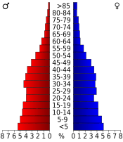
In 2010, there were 36,776 people living in Finney County. There were 12,359 households. A household is a group of people living in the same home. About 8,903 of these were families.
The people living in the county came from many different backgrounds. About 77% were White. About 2.3% were Black or African American. About 0.9% were Native American. About 3.4% were Asian. A small number were Pacific Islander. About 13.6% were from other races. And 2.9% were from two or more races. A large group, 46.7%, were Hispanic or Latino.
Learning in Finney County
Finney County has two main school districts. These districts manage the public schools in the area.
Unified School Districts
- Holcomb USD 363
- Garden City USD 457
Places to Live
Finney County has several cities and smaller communities. Some places are called "unincorporated communities." This means they don't have their own local government like a city does. Some communities are also called "Census-Designated Places" (CDP). This means the U.S. Census Bureau counts them as a specific place.
Main Cities
These are the biggest cities in Finney County:
- Garden City (This is the county seat, where the main government offices are)
- Holcomb
Smaller Towns
These are smaller communities in Finney County:
Old Towns
These are places that used to be towns but are now "ghost towns." This means no one lives there anymore.
See also
 In Spanish: Condado de Finney para niños
 | George Robert Carruthers |
 | Patricia Bath |
 | Jan Ernst Matzeliger |
 | Alexander Miles |


