
Kearny County, Kansas facts for kids
Quick facts for kids
Kearny County
|
|
|---|---|

Kearny County Courthouse in Lakin (2015)
|
|

Location within the U.S. state of Kansas
|
|
 Kansas's location within the U.S. |
|
| Country | |
| State | |
| Founded | March 20, 1873 |
| Named for | Philip Kearny |
| Seat | Lakin |
| Largest city | Lakin |
| Area | |
| • Total | 871 sq mi (2,260 km2) |
| • Land | 871 sq mi (2,260 km2) |
| • Water | 0.4 sq mi (1 km2) 0.05%% |
| Population
(2020)
|
|
| • Total | 3,983 |
| • Density | 4.6/sq mi (1.8/km2) |
| Time zone | UTC−6 (Central) |
| • Summer (DST) | UTC−5 (CDT) |
| Congressional district | 1st |
Kearny County is a county in Kansas, a state in the United States. Its main city and county seat (where the county government is) is Lakin. In 2020, about 3,983 people lived here. The county is named after Philip Kearny, a brave general who fought in the American Civil War.
Contents
History of Kearny County
Kearny County has an interesting past! It was first created on March 6, 1873. But then, in 1883, it was split up between two other counties.
How Kearny County was Recreated
The county was put back together with its original borders in 1887. It officially started working again on March 27, 1888. The county is named after Philip Kearny. He was a U.S. Army officer who fought in the Mexican–American War. He was also a general for the Union army during the American Civil War. In 1889, the county's name was officially changed to "Kearny County" to fix a spelling mistake.
Early Days: Cow Country to Farms
Before people settled here, Kearny County was mostly "cow country." This means it was open land where cattle grazed freely. There were no farms or towns.
In the mid-1880s, people called homesteaders started moving in. They wanted to claim land and start farms. This caused some arguments with the cattle ranchers. The ranchers were used to having open land for their herds. Towns like Leeser (1885) and Pierceville (1886) were built for the cattle business. But they disappeared as more farmers arrived.
The Dust Bowl Years
In the 1930s, Kearny County faced a very tough time. It was part of the Dust Bowl. This was a period when severe dust storms hit the Great Plains. It made the Great Depression even harder for the people living there.
Geography of Kearny County
Kearny County covers about 871 square miles. Most of this area is land. Only a tiny part (about 0.4 square miles) is water.
Main Roads in Kearny County
You can travel through Kearny County on these important roads:
Time Zones in Kearny County
Most of Kansas uses the Central Time Zone. But some counties on the western side used to be in the Mountain Time Zone. Until 1990, the western part of Kearny County was in Mountain Time. Now, the whole county is in the Central Time Zone. Only four counties in Kansas still use Mountain Time. These counties are Hamilton, Greeley, Wallace, and Sherman. They are all next to Colorado.
Neighboring Counties
Kearny County shares its borders with these other counties:
- Wichita County (to the north)
- Scott County (to the northeast)
- Finney County (to the east)
- Grant County (to the south)
- Stanton County (to the southwest)
- Hamilton County (to the west)
People of Kearny County
Kearny County is part of the Garden City, KS area. This area is known as a Micropolitan Statistical Area. It means it's a smaller city area with close ties to nearby towns.
In 2020, the population of Kearny County was 3,983 people. The county has grown a lot since it was first settled. For example, in 1880, only 159 people lived here.
Education in Kearny County
Kids in Kearny County go to schools run by unified school districts. These districts manage all the public schools in their area.
School Districts
- Lakin USD 215
- Deerfield USD 216
Communities in Kearny County
Kearny County has a few towns and areas where people live.
Cities in Kearny County
Townships
Kearny County is divided into seven smaller areas called townships. These are ways to organize the land. The populations of the cities are included in the township totals.
Images for kids
-
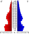
Population pyramid based on 2000 census age data
-
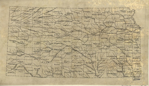
2005 map of Kearny County
-
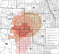
Area affected by 1930s Dust Bowl


.svg)
See also
 In Spanish: Condado de Kearny para niños
