Hamilton County, Kansas facts for kids
Quick facts for kids
Hamilton County
|
|
|---|---|

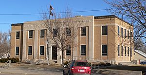
Hamilton County Courthouse in Syracuse (2010)
|
|

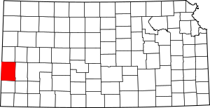
Location within the U.S. state of Kansas
|
|
 Kansas's location within the U.S. |
|
| Country | |
| State | |
| Founded | March 20, 1873 |
| Named for | Alexander Hamilton |
| Seat | Syracuse |
| Largest city | Syracuse |
| Area | |
| • Total | 998 sq mi (2,580 km2) |
| • Land | 997 sq mi (2,580 km2) |
| • Water | 1.1 sq mi (3 km2) 0.1%% |
| Population
(2020)
|
|
| • Total | 2,518 |
| • Density | 2.5/sq mi (1.0/km2) |
| Time zone | UTC−7 (Mountain) |
| • Summer (DST) | UTC−6 (MDT) |
| Congressional district | 1st |
| Website | County Info |
Hamilton County is a county in the state of Kansas. It is located in the western part of Kansas. The main town and county seat is Syracuse. In 2020, about 2,518 people lived there. The county was started in 1873. It was named after Alexander Hamilton, who was one of the important people who helped create the United States.
Contents
History of Hamilton County
For thousands of years, the Great Plains of North America were home to nomadic Native American tribes. These groups moved around to hunt and find food.
In 1854, the area became the Kansas Territory. Then, in 1861, Kansas officially became the 34th U.S. state.
Hamilton County was created in 1873. It was given its name to honor Alexander Hamilton. He was a very important person in early American history.
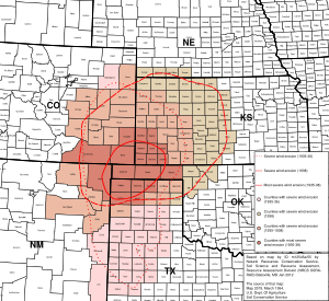
In the 1930s, the county faced a very tough time. It was part of the Dust Bowl. This was a period when severe dust storms hit the Great Plains. It made farming very hard and caused many people to lose their homes and jobs. This made the Great Depression even worse for the people living in Hamilton County.
Geography
Hamilton County covers a total area of about 998 square miles. Most of this area, about 997 square miles, is land. Only a small part, about 1.1 square miles, is water.
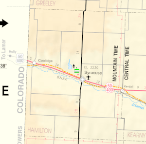
Main Roads
Neighboring Counties
Hamilton County shares borders with several other counties:
- Greeley County (to the north)
- Wichita County (to the northeast)
- Kearny County (to the east)
- Stanton County (to the south)
- Prowers County, Colorado (to the west)
Population Information
| Historical population | |||
|---|---|---|---|
| Census | Pop. | %± | |
| 1880 | 168 | — | |
| 1890 | 2,027 | 1,106.5% | |
| 1900 | 1,426 | −29.6% | |
| 1910 | 3,360 | 135.6% | |
| 1920 | 2,586 | −23.0% | |
| 1930 | 3,328 | 28.7% | |
| 1940 | 2,645 | −20.5% | |
| 1950 | 3,696 | 39.7% | |
| 1960 | 3,144 | −14.9% | |
| 1970 | 2,747 | −12.6% | |
| 1980 | 2,514 | −8.5% | |
| 1990 | 2,388 | −5.0% | |
| 2000 | 2,670 | 11.8% | |
| 2010 | 2,690 | 0.7% | |
| 2020 | 2,518 | −6.4% | |
| 2023 (est.) | 2,437 | −9.4% | |
| U.S. Decennial Census 1790-1960 1900-1990 1990-2000 2010-2020 |
|||
In 2000, there were 2,670 people living in Hamilton County. There were 1,054 households, which are groups of people living together.
About 28.4% of the population was under 18 years old. About 18.4% were 65 years or older. The average age in the county was 38 years.
Education
Students in Hamilton County attend schools in one main school district.
School Districts
- Syracuse USD 494
Communities
Hamilton County has a few towns and smaller communities.
Cities
Unincorporated Community
Townships
Hamilton County is divided into eight smaller areas called townships. These townships help organize the county. The populations listed for each township include the people living in any cities within that township.
| Township | Population | Land area km2 (sq mi) |
Geographic coordinates |
|---|---|---|---|
| Bear Creek | 69 | 452 (174) | 37°49′19″N 101°56′36″W / 37.82194°N 101.94333°W |
| Coolidge | 128 | 297 (115) | 38°2′22″N 101°59′41″W / 38.03944°N 101.99472°W |
| Kendall | 101 | 234 (90) | 37°59′41″N 101°35′3″W / 37.99472°N 101.58417°W |
| Lamont | 89 | 426 (164) | 37°48′9″N 101°38′41″W / 37.80250°N 101.64472°W |
| Liberty | 38 | 257 (99) | 38°7′29″N 101°44′4″W / 38.12472°N 101.73444°W |
| Medway | 53 | 279 (108) | 38°4′51″N 101°51′13″W / 38.08083°N 101.85361°W |
| Richland | 27 | 426 (164) | 38°13′21″N 101°46′17″W / 38.22250°N 101.77139°W |
| Syracuse | 2,165 | 210 (81) | 37°59′10″N 101°45′5″W / 37.98611°N 101.75139°W |
Images for kids
-
The Hamilton County Public Library in Syracuse
-
Christ's New Covenant Church and Syracuse Christian Academy in Syracuse
See also
 In Spanish: Condado de Hamilton (Kansas) para niños
 | Frances Mary Albrier |
 | Whitney Young |
 | Muhammad Ali |


