
Wichita County, Kansas facts for kids
Quick facts for kids
Wichita County
|
|
|---|---|

Wichita County Courthouse in Leoti (2015)
|
|

Location within the U.S. state of Kansas
|
|
 Kansas's location within the U.S. |
|
| Country | |
| State | |
| Founded | December 24, 1886 |
| Named for | Wichita tribe |
| Seat | Leoti |
| Largest city | Leoti |
| Area | |
| • Total | 719 sq mi (1,860 km2) |
| • Land | 719 sq mi (1,860 km2) |
| • Water | 0.02 sq mi (0.05 km2) 0.0% |
| Population
(2020)
|
|
| • Total | 2,152 |
| • Density | 3.0/sq mi (1.2/km2) |
| Time zone | UTC−6 (Central) |
| • Summer (DST) | UTC−5 (CDT) |
| Congressional district | 1st |
Wichita County is a place in the state of Kansas, in the United States. The main town and center of the county is Leoti. In 2020, about 2,152 people lived here. The county got its name from the Wichita tribe, a Native American group.
Contents
History of Wichita County
Early Times
For thousands of years, the Great Plains of North America were home to nomadic Native American groups. These groups moved around to hunt and find food.
From the 1500s to the 1700s, France said it owned large parts of North America. In 1762, after a big war called the French and Indian War, France secretly gave a lot of its land, known as New France, to Spain. This was part of a deal called the Treaty of Fontainebleau.
The 1800s
In 1802, Spain gave most of this land back to France. But Spain kept about 7,500 square miles for itself.
Then, in 1803, the United States bought a huge area of land from France. This was called the Louisiana Purchase. Most of what is now Kansas was part of this purchase. The United States paid about 2.83 cents for each acre.
In 1854, the Kansas Territory was set up. Later, in 1861, Kansas became the 34th state in the U.S. Wichita County was officially created in 1886.
Geography
Wichita County covers a total area of about 719 square miles (1,862 square kilometers). Almost all of this area is land.
Main Roads
 Kansas Highway 25
 Kansas Highway 96
Neighboring Counties
Wichita County shares borders with these other counties:
- Logan County (to the north)
- Scott County (to the east)
- Kearny County (to the south)
- Hamilton County (to the southwest)
- Greeley County (to the west)
- Wallace County (to the northwest)
Population Information
| Historical population | |||
|---|---|---|---|
| Census | Pop. | %± | |
| 1880 | 14 | — | |
| 1890 | 1,827 | 12,950.0% | |
| 1900 | 1,197 | −34.5% | |
| 1910 | 2,006 | 67.6% | |
| 1920 | 1,856 | −7.5% | |
| 1930 | 2,579 | 39.0% | |
| 1940 | 2,185 | −15.3% | |
| 1950 | 2,640 | 20.8% | |
| 1960 | 2,765 | 4.7% | |
| 1970 | 3,274 | 18.4% | |
| 1980 | 3,041 | −7.1% | |
| 1990 | 2,758 | −9.3% | |
| 2000 | 2,531 | −8.2% | |
| 2010 | 2,234 | −11.7% | |
| 2020 | 2,152 | −3.7% | |
| 2023 (est.) | 2,082 | −6.8% | |
| U.S. Decennial Census 1790-1960 1900-1990 1990-2000 2010-2020 |
|||
In 2000, there were 2,531 people living in Wichita County. The county had 967 households and 723 families. The average number of people in each household was about 2.59.
The population was made up of different age groups. About 28.7% of the people were under 18 years old. About 16% of the people were 65 years old or older. The average age in the county was 37 years.
Education
- Leoti USD 467 is the local school district in Wichita County.
Communities

Wichita County has several towns and communities. Some are official cities, while others are smaller, unincorporated places. There are also some "ghost towns" that used to be active but are now mostly empty.
Cities
- Leoti is the main city and the county seat.
Unincorporated Communities
These are smaller places that are not officially organized as cities:
Ghost Towns
Townships
Wichita County has one main area called a township. This township includes all the cities and communities within the county.
| Township | FIPS | Population center |
Population | Population density /km2 (/sq mi) |
Land area km2 (sq mi) |
Water area km2 (sq mi) |
Water % | Geographic coordinates |
|---|---|---|---|---|---|---|---|---|
| Leoti | 39575 | Leoti | 2,531 | 1 (4) | 1,861 (719) | 0 (0) | 0% | 38°29′54″N 101°21′50″W / 38.49833°N 101.36389°W |
Images for kids
-
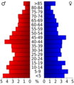
This chart shows the age groups of people in Wichita County based on the 2000 census.

See also
 In Spanish: Condado de Wichita (Kansas) para niños
