Sedgwick County, Kansas facts for kids
Quick facts for kids
Sedgwick County
|
|
|---|---|
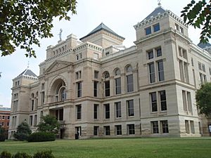
Old Sedgwick County Courthouse in Wichita (2009)
|
|
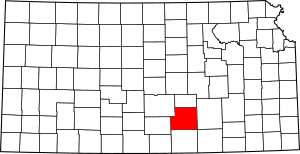
Location within the U.S. state of Kansas
|
|
 Kansas's location within the U.S. |
|
| Country | |
| State | |
| Founded | February 26, 1867 |
| Named for | John Sedgwick |
| Seat | Wichita |
| Largest city | Wichita |
| Area | |
| • Total | 1,009 sq mi (2,610 km2) |
| • Land | 998 sq mi (2,580 km2) |
| • Water | 12 sq mi (30 km2) 1.2% |
| Population
(2020)
|
|
| • Total | 523,824 |
| • Estimate
(2023)
|
528,469 |
| • Density | 524.9/sq mi (202.7/km2) |
| Time zone | UTC−6 (Central) |
| • Summer (DST) | UTC−5 (CDT) |
| Area code | 316 |
| Congressional district | 4th |
Sedgwick County is a place in Kansas, a state in the United States. Its main city, called the county seat, is Wichita. Wichita is also the biggest city in all of Kansas!
In 2020, about 523,824 people lived here. This makes Sedgwick County the second most populated county in Kansas. The county got its name from John Sedgwick. He was an important general during the American Civil War.
Contents
History of Sedgwick County
Sedgwick County has a long and interesting past. It includes times when Native Americans lived here and when different countries claimed the land.
Early Days of Kansas
For thousands of years, Native American groups lived on the Great Plains of North America. They often moved around, following animal herds.
Later, from the 1500s to the 1700s, France said they owned large parts of North America. In 1762, after a big war, France secretly gave this land to Spain.
Then, in 1803, the United States bought most of the land that is now Kansas from France. This huge purchase was called the Louisiana Purchase. It cost about 2.83 cents for every acre!
After another war, the Mexican–American War, more land was added to the U.S. in 1848. This included parts of what would become southwest Kansas. Finally, in 1854, the Kansas Territory was set up. Kansas officially became the 34th U.S. state in 1861.
How Sedgwick County Began
Sedgwick County was officially created in 1867. It was named after John Sedgwick. He was a very important Major General in the Union Army during the American Civil War.
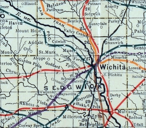
In 1887, a railway company built a train line through the county. This line connected many towns, including Wichita. People in the area still often call this railroad the "Rock Island."
20th Century Events
Sedgwick County was the location for a series of crimes that happened between 1974 and 1991.
Geography and Neighbors
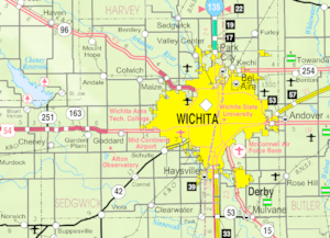
Sedgwick County covers a total area of about 1,009 square miles. Most of this is land, with about 12 square miles being water.
Counties Nearby
Sedgwick County shares its borders with several other counties:
- To the north: Harvey County
- To the east: Butler County
- To the southeast: Cowley County
- To the south: Sumner County
- To the west: Kingman County
- To the northwest: Reno County
People and Population
| Historical population | |||
|---|---|---|---|
| Census | Pop. | %± | |
| 1870 | 1,095 | — | |
| 1880 | 18,753 | 1,612.6% | |
| 1890 | 43,626 | 132.6% | |
| 1900 | 44,037 | 0.9% | |
| 1910 | 73,095 | 66.0% | |
| 1920 | 92,234 | 26.2% | |
| 1930 | 136,330 | 47.8% | |
| 1940 | 143,311 | 5.1% | |
| 1950 | 222,290 | 55.1% | |
| 1960 | 343,231 | 54.4% | |
| 1970 | 350,694 | 2.2% | |
| 1980 | 366,531 | 4.5% | |
| 1990 | 403,662 | 10.1% | |
| 2000 | 452,869 | 12.2% | |
| 2010 | 498,365 | 10.0% | |
| 2020 | 523,824 | 5.1% | |
| 2023 (est.) | 528,469 | 6.0% | |
| U.S. Decennial Census 1790-1960 1900–1990 1990-2000 2010–2020 |
|||
Sedgwick County is part of the larger Wichita Metropolitan Area. This means it's connected to Wichita and the towns around it.
In 2000, there were about 452,869 people living in the county. About 34.4% of homes had children under 18 living there. The average age of people in the county was 34 years old.
Economy and Businesses
Sedgwick County is famous for being the starting place of some well-known restaurants. These include White Castle and Pizza Hut!
It's also a very important place for making airplanes. Companies like Cessna and Learjet have their main offices here.
Getting Around: Transportation
Sedgwick County has several airports that help people travel by air.
Airports in Sedgwick County
Here are some of the public airports you can find in the county:
- Wichita Dwight D. Eisenhower National Airport (ICT)
- Beech Factory Airport (BEC)
- Cessna Aircraft Field (CEA)
- Colonel James Jabara Airport (AAO)
- Cook Airfield (K50)
- Maize Airport (70K)
- Westport Airport (71K)
- Westport Auxiliary Airport (72K)
Some airports that used to be open are now closed, like Riverside Airport.
Learning and Education
Sedgwick County offers many places for learning, from colleges to local schools.
Colleges and Universities
If you want to go to college, here are some options in Sedgwick County:
- Friends University
- Kansas College of Osteopathic Medicine
- Newman University
- University of Kansas School of Medicine
- WSU Tech
- Wichita State University
School Districts
The county is divided into many different school districts. These districts manage the public schools for students of all ages.
- Andover USD 385
- Burrton USD 369
- Cheney USD 268
- Circle USD 375
- Clearwater USD 264
- Conway Springs USD 356
- Derby USD 260
- Goddard USD 265
- Halstead–Bentley USD 440
- Haven USD 312
- Haysville USD 261
- Kingman-Norwich USD 331
- Maize USD 266
- Mulvane USD 263
- Remington USD 206
- Renwick USD 267
- Rose Hill USD 394
- Sedgwick USD 439
- Valley Center USD 262
- Wichita USD 259
Fun Places to Visit
Sedgwick County has many interesting spots where you can have fun or learn something new!
- Sedgwick County Extension Arboretum: A place with many different kinds of trees and plants.
- Sedgwick County Zoo: A popular zoo with animals from all over the world.
- Sedgwick County Fair: A yearly event with rides, games, and exhibits.
- Wichita-Sedgwick County Historical Museum: Learn about the history of the area.
- INTRUST Bank Arena: A large place where concerts and sports events happen.
Towns and Communities
Sedgwick County has many different cities and smaller communities.
Cities in Sedgwick County
Special Census Areas
These are places that are counted separately for the census, but aren't official cities:
- McConnell AFB
- Oaklawn-Sunview
Smaller Unincorporated Places
These are smaller communities that are not officially part of a city:
Towns That No Longer Exist
Some towns that used to be in Sedgwick County are now "ghost towns." This means people no longer live there.
- Davidson
- Hatfield
- Huckle
- Jamesburg
- Marshall
- Oatville
- Wichita Heights
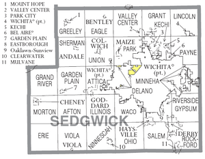
Townships of Sedgwick County
Sedgwick County is divided into 27 smaller areas called townships. The cities of Bel Aire and Wichita are separate and not part of these township numbers.
| Township | FIPS | Main City | Population | Population density /km² (/sq mi) |
Land area km² (sq mi) |
Water area km² (sq mi) |
Water % | Geographic coordinates |
|---|---|---|---|---|---|---|---|---|
| Afton | 00425 | 1,290 | 14 (37) | 91 (35) | 2 (1) | 1.73% | 37°36′10″N 97°37′54″W / 37.60278°N 97.63167°W | |
| Attica | 03125 | Goddard | 4,959 | 62 (161) | 80 (31) | 0 (0) | 0.23% | 37°40′44″N 97°32′16″W / 37.67889°N 97.53778°W |
| Delano | 17375 | 196 | 25 (64) | 8 (3) | 1 (0) | 13.81% | 37°43′2″N 97°25′13″W / 37.71722°N 97.42028°W | |
| Eagle | 19250 | Bentley | 1,069 | 12 (30) | 92 (36) | 1 (1) | 1.44% | 37°51′48″N 97°32′26″W / 37.86333°N 97.54056°W |
| Erie | 21550 | 106 | 1 (3) | 94 (36) | 0 (0) | 0.03% | 37°31′24″N 97°44′51″W / 37.52333°N 97.74750°W | |
| Garden Plain | 25400 | Garden Plain | 1,780 | 19 (50) | 92 (36) | 0 (0) | 0.15% | 37°40′25″N 97°39′47″W / 37.67361°N 97.66306°W |
| Grand River | 27300 | 607 | 7 (17) | 91 (35) | 2 (1) | 2.20% | 37°40′6″N 97°45′14″W / 37.66833°N 97.75389°W | |
| Grant | 28125 | Valley Center (part) | 3,710 | 40 (104) | 93 (36) | 0 (0) | 0.47% | 37°50′55″N 97°20′23″W / 37.84861°N 97.33972°W |
| Greeley | 28400 | Mount Hope | 1,094 | 12 (31) | 93 (36) | 1 (1) | 1.43% | 37°52′21″N 97°39′17″W / 37.87250°N 97.65472°W |
| Gypsum | 29300 | 5,822 | 64 (164) | 92 (35) | 0 (0) | 0.51% | 37°36′26″N 97°12′34″W / 37.60722°N 97.20944°W | |
| Illinois | 33775 | 1,620 | 18 (45) | 93 (36) | 0 (0) | 0.12% | 37°35′54″N 97°31′53″W / 37.59833°N 97.53139°W | |
| Kechi | 36250 | Park City | 8,041 | 143 (370) | 56 (22) | 0 (0) | 0.23% | 37°47′35″N 97°19′14″W / 37.79306°N 97.32056°W |
| Lincoln | 41150 | 473 | 5 (13) | 91 (35) | 0 (0) | 0.12% | 37°52′35″N 97°11′53″W / 37.87639°N 97.19806°W | |
| Minneha | 47125 | Eastborough | 5,084 | 117 (304) | 43 (17) | 1 (0) | 1.49% | 37°41′11″N 97°11′25″W / 37.68639°N 97.19028°W |
| Morton | 48550 | Cheney | 2,380 | 26 (67) | 91 (35) | 1 (0) | 1.14% | 37°37′24″N 97°46′33″W / 37.62333°N 97.77583°W |
| Ninnescah | 50725 | Clearwater | 2,913 | 31 (81) | 93 (36) | 0 (0) | 0.47% | 37°30′51″N 97°31′28″W / 37.51417°N 97.52444°W |
| Ohio | 52450 | 1,146 | 12 (32) | 94 (36) | 0 (0) | 0.14% | 37°31′56″N 97°25′21″W / 37.53222°N 97.42250°W | |
| Park | 54425 | Maize | 4,128 | 51 (131) | 82 (32) | 2 (1) | 2.04% | 37°46′26″N 97°26′13″W / 37.77389°N 97.43694°W |
| Payne | 55075 | 1,119 | 14 (36) | 80 (31) | 0 (0) | 0.21% | 37°46′58″N 97°12′22″W / 37.78278°N 97.20611°W | |
| Riverside | 60125 | Haysville (part) Derby (part) Oaklawn-Sunview CDP |
15,694 | 333 (862) | 47 (18) | 1 (0) | 1.98% | 37°34′56″N 97°18′22″W / 37.58222°N 97.30611°W |
| Rockford | 60675 | Derby (part) | 20,019 | 198 (514) | 101 (39) | 1 (0) | 0.99% | 37°31′55″N 97°14′47″W / 37.53194°N 97.24639°W |
| Salem | 62675 | Haysville (part) | 8,411 | 102 (263) | 83 (32) | 1 (0) | 0.95% | 37°32′23″N 97°20′11″W / 37.53972°N 97.33639°W |
| Sherman | 65100 | Andale | 1,362 | 14 (37) | 96 (37) | 0 (0) | 0.22% | 37°47′23″N 97°38′4″W / 37.78972°N 97.63444°W |
| Union | 72375 | Colwich | 2,156 | 23 (60) | 93 (36) | 0 (0) | 0.23% | 37°46′55″N 97°32′8″W / 37.78194°N 97.53556°W |
| Valley Center | 73275 | Valley Center (part) | 3,642 | 39 (100) | 94 (36) | 0 (0) | 0.16% | 37°51′22″N 97°24′10″W / 37.85611°N 97.40278°W |
| Viola | 74050 | Viola | 547 | 6 (15) | 93 (36) | 1 (0) | 0.98% | 37°30′41″N 97°39′3″W / 37.51139°N 97.65083°W |
| Waco | 74300 | 3,381 | 45 (117) | 75 (29) | 0 (0) | 0.12% | 37°36′35″N 97°24′57″W / 37.60972°N 97.41583°W |
See also
 In Spanish: Condado de Sedgwick (Kansas) para niños
 | James Van Der Zee |
 | Alma Thomas |
 | Ellis Wilson |
 | Margaret Taylor-Burroughs |


