
Sumner County, Kansas facts for kids
Quick facts for kids
Sumner County
|
|
|---|---|

Old Oxford Mill in Oxford (2012)
|
|

Location within the U.S. state of Kansas
|
|
 Kansas's location within the U.S. |
|
| Country | |
| State | |
| Founded | December 20, 1870 |
| Named for | Charles Sumner |
| Seat | Wellington |
| Largest city | Wellington |
| Area | |
| • Total | 1,185 sq mi (3,070 km2) |
| • Land | 1,182 sq mi (3,060 km2) |
| • Water | 3.0 sq mi (8 km2) 0.3% |
| Population
(2020)
|
|
| • Total | 22,382 |
| • Estimate
(2023)
|
22,334 |
| • Density | 18.9/sq mi (7.3/km2) |
| Time zone | UTC−6 (Central) |
| • Summer (DST) | UTC−5 (CDT) |
| Area code | 620 |
| Congressional district | 4th |
Sumner County is a county located in the state of Kansas, USA. Its main town, called the county seat, is Wellington. In 2020, about 22,382 people lived there.
The county is named after Charles Sumner. He was a U.S. Senator from Massachusetts. He was an important leader during a time in American history called Reconstruction.
Contents
History of Sumner County
Early Days in Kansas
For thousands of years, the Great Plains of North America were home to nomadic Native American groups. They moved around to hunt and find food.
From the 1500s to the 1700s, France claimed a lot of land in North America. After a big war called the French and Indian War in 1762, France secretly gave this land to Spain.
In 1802, Spain gave most of the land back to France. But Spain kept about 7,500 square miles.
How Kansas Became Part of the USA
In 1803, the United States bought a huge area of land from France. This was called the Louisiana Purchase. It was 828,000 square miles, and it cost about 2.83 cents per acre. Most of what is now Kansas was part of this purchase.
Later, in 1848, after the Mexican–American War, the Treaty of Guadalupe Hidalgo added more land to the United States. This included parts of southwest Kansas. In 1854, the Kansas Territory was set up. Then, in 1861, Kansas officially became the 34th U.S. state.
Sumner County is Created
Sumner County was officially created on February 26, 1867. It was formed from parts of Marion County and Butler County.
It was named after Charles Sumner. He was a U.S. Senator from Massachusetts. Senator Sumner strongly believed that Kansas should be a free state, meaning it would not allow slavery.
Railroads Arrive
In 1887, the Chicago, Kansas and Nebraska Railway built a train line. It ran north and south from Herington to Caldwell. This line connected many towns, including Wellington in Sumner County.
By 1893, this train line reached all the way to Fort Worth, Texas. Over the years, different railroad companies owned this line. Today, it is part of the Union Pacific Railroad system. Many local people still call it the "Rock Island" line.
Recent Developments
In December 2011, the Kansas Star Casino opened. It is located near Mulvane in Sumner County. It is close to an exit on the Kansas Turnpike.
Geography of Sumner County
Sumner County covers a total area of about 1,185 square miles. Most of this is land, about 1,182 square miles. A small part, about 3.0 square miles, is water.
Neighboring Counties
Sumner County shares borders with several other counties:
- Sedgwick County (to the north)
- Butler County (to the northeast)
- Cowley County (to the east)
- Kay County, Oklahoma (to the southeast)
- Grant County, Oklahoma (to the southwest)
- Harper County (to the west)
- Kingman County (to the northwest)
People of Sumner County

Sumner County is part of the larger Wichita Metropolitan Statistical Area. This means it is connected to the bigger city of Wichita.
In 2000, there were 25,946 people living in Sumner County. There were 9,888 households, which are groups of people living together. About 7,089 of these were families. The county had about 22 people per square mile.
Most people in the county were White (94.62%). Other groups included Black or African American (0.71%), Native American (1.05%), and Asian (0.22%). About 3.58% of the population was Hispanic or Latino.
About 34.50% of households had children under 18 living with them. Many households (59.90%) were married couples. The average household had 2.58 people. The average family had 3.10 people.
The population was spread out by age. About 28.50% were under 18. About 15.50% were 65 or older. The median age was 38 years old. This means half the people were younger than 38 and half were older.
The median income for a household in the county was $39,415. For a family, it was $46,739. About 9.50% of all people in the county lived below the poverty line. This included 11.20% of those under 18.
Education in Sumner County
Sumner County has several school districts. These districts manage the public schools in different areas of the county.
School Districts
- Mulvane USD 263
- Wellington USD 353
- Conway Springs USD 356
- Belle Plaine USD 357
- Oxford USD 358
- Argonia USD 359
- Caldwell USD 360
- South Haven USD 509
Communities in Sumner County

Sumner County has many different communities. These include cities, smaller unincorporated communities, and even some places that used to be towns but are now "ghost towns."
Cities in Sumner County
Some cities in Sumner County might have parts in a neighboring county.
Unincorporated Communities
These are smaller communities that are not officially cities. Some are called Census-Designated Places (CDP) by the United States Census Bureau.
Ghost Towns
Townships in Sumner County

Sumner County is divided into thirty areas called townships. The cities of Caldwell and Wellington are separate from these townships for census counting.
| Township | Population | Population density /km2 (/sq mi) |
Land area km2 (sq mi) |
Water area km2 (sq mi) |
Water % |
|---|---|---|---|---|---|
| Avon | 319 | 3 (9) | 93 (36) | 0 (0) | 0.03% |
| Belle Plaine | 3,504 | 33 (87) | 105 (40) | 1 (0) | 0.69% |
| Bluff | 74 | 1 (1) | 136 (53) | 0 (0) | 0% |
| Caldwell | 200 | 1 (4) | 136 (52) | 0 (0) | 0.02% |
| Chikaskia | 69 | 1 (2) | 94 (36) | 0 (0) | 0.02% |
| Conway | 1,286 | 14 (35) | 94 (36) | 0 (0) | 0% |
| Creek | 241 | 3 (7) | 95 (37) | 0 (0) | 0.05% |
| Dixon | 738 | 8 (20) | 94 (36) | 0 (0) | 0% |
| Downs | 159 | 2 (5) | 91 (35) | 0 (0) | 0% |
| Eden | 452 | 5 (12) | 95 (37) | 0 (0) | 0% |
| Falls | 187 | 1 (3) | 139 (54) | 0 (0) | 0% |
| Gore | 2,220 | 27 (70) | 83 (32) | 1 (1) | 1.69% |
| Greene | 80 | 1 (2) | 93 (36) | 0 (0) | 0.10% |
| Guelph | 164 | 1 (3) | 141 (55) | 0 (0) | 0% |
| Harmon | 277 | 3 (9) | 79 (31) | 0 (0) | 0% |
| Illinois | 178 | 2 (5) | 94 (36) | 0 (0) | 0.05% |
| Jackson | 153 | 2 (4) | 94 (36) | 0 (0) | 0.02% |
| London | 774 | 7 (19) | 107 (41) | 1 (0) | 0.93% |
| Morris | 35 | 0 (1) | 94 (36) | 0 (0) | 0% |
| Osborne | 273 | 3 (8) | 92 (35) | 1 (0) | 1.30% |
| Oxford | 1,403 | 14 (37) | 99 (38) | 1 (0) | 1.08% |
| Palestine | 249 | 3 (9) | 72 (28) | 1 (0) | 1.26% |
| Ryan | 239 | 3 (7) | 92 (36) | 0 (0) | 0% |
| Seventy Six | 238 | 3 (7) | 93 (36) | 0 (0) | 0% |
| South Haven | 670 | 5 (12) | 140 (54) | 0 (0) | 0% |
| Springdale | 761 | 8 (21) | 93 (36) | 0 (0) | 0% |
| Sumner | 150 | 2 (4) | 94 (36) | 0 (0) | 0% |
| Valverde | 147 | 2 (4) | 93 (36) | 1 (0) | 0.76% |
| Walton | 431 | 3 (8) | 139 (54) | 0 (0) | 0% |
| Wellington | 344 | 4 (11) | 81 (31) | 0 (0) | 0.06% |
Images for kids
-
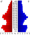
This chart shows the age groups of people in Sumner County in 2000.
-
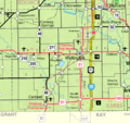
A 2005 map showing the towns and areas of Sumner County.
-
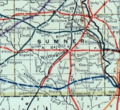
A 1915 map showing the railroad lines in Sumner County.
See also
 In Spanish: Condado de Sumner (Kansas) para niños
