
Marion County, Kansas facts for kids
Quick facts for kids
Marion County
|
|
|---|---|

Marion County Courthouse in Marion (2009)
|
|

Location within the U.S. state of Kansas
|
|
 Kansas's location within the U.S. |
|
| Country | |
| State | |
| Founded | August 30, 1855 |
| Named for | Francis Marion |
| Seat | Marion |
| Largest city | Hillsboro |
| Area | |
| • Total | 954 sq mi (2,470 km2) |
| • Land | 944 sq mi (2,440 km2) |
| • Water | 9.4 sq mi (24 km2) 1.0% |
| Population
(2020)
|
|
| • Total | 11,823 |
| • Density | 12.5/sq mi (4.8/km2) |
| Time zone | UTC−6 (Central) |
| • Summer (DST) | UTC−5 (CDT) |
| Area code | 620, 785 |
| Congressional district | 2nd |
Marion County is a county in Kansas, USA. Its main city and government center is Marion. The largest city is Hillsboro. In 2020, about 11,823 people lived here. The county is named after Francis Marion, a famous general from the American Revolutionary War. He was known as the "Swamp Fox."
Contents
History of Marion County

Early Beginnings
For thousands of years, Native Americans lived on the Great Plains of North America. In the 16th to 18th centuries, France claimed much of this land. After a war in 1762, France secretly gave this land to Spain.
The 1800s: New Lands and Trails
In 1803, the United States bought most of the land that is now Kansas from France. This was part of the huge Louisiana Purchase. Later, in 1848, more land in southwest Kansas became part of the U.S. after the Mexican–American War.
In 1806, explorer Zebulon Pike traveled through what is now Marion County. His journey followed the Cottonwood River.
In 1854, the Kansas Territory was created. Kansas became the 34th U.S. state in 1861. Marion County was officially formed in 1855. The first settlers arrived in 1858 near Florence. The city of Marion Centre was founded in 1860 and became the county seat in 1865. Its name was later shortened to Marion.

From 1821 to 1866, the famous Santa Fe Trail crossed Marion County. This trail was a busy trade route. In 1859, a trading post was set up at "Lost Spring." This became an important stop for travelers.
From 1867 to 1871, the Chisholm Trail ran along the western edge of the county. This trail was used to move cattle from Texas to Abilene, Kansas, where they were sent by train.
Originally, Marion County was much larger. Its borders changed several times. In 1863, the county was made very large, covering much of southwest Kansas. But soon after, it returned to smaller borders. A unique one-mile "notch" on the southeastern border was given to Chase County due to a past event. Today, Marion County has twenty-four townships.
The first stone courthouse was built in 1867. It was also used as a school. The current courthouse, made of limestone, was finished in 1907.
Railroads Connect the County

Railroads were very important for Marion County's growth. The Atchison, Topeka and Santa Fe Railway (often called "Santa Fe") built lines through the county starting in the 1870s. These lines connected towns like Florence, Peabody, and Marion to other parts of Kansas and beyond. The Santa Fe railroad helped transport goods and people, making the county more connected.

Another major railroad was the Chicago, Rock Island and Pacific Railway (known as "Rock Island"). In 1887, it built a main line through towns like Durham and Tampa. It also built a line connecting Herington to Caldwell, passing through Lost Springs and Peabody. These railroads helped towns grow and made it easier for farmers to send their products to markets.
Today, the Santa Fe railway is part of BNSF Railway, and the Rock Island lines are part of Union Pacific Railroad. Locals still often use the old names.
The 1900s: Roads and Oil
The National Old Trails Road, an early cross-country highway, was established in 1912. It passed through Lehigh, Hillsboro, Marion, and Lost Springs.
From 1918 to 1920, Peabody had an oil boom. Many people moved there for work, and the town grew quickly. Later, as oil discoveries happened elsewhere, some workers moved on.
In the 1930s, the Marion County Lake was built. Later, from 1964 to 1968, the larger Marion Reservoir was constructed. These provide water and recreation.
The 2000s: Pipelines and Wind Energy

In 2010, the Keystone-Cushing Pipeline was built through Marion County. This pipeline carries oil.
More recently, in 2022, construction began on the Sunflower Wind farm. This large wind farm, located near Peabody, uses wind turbines to create clean energy. It started testing in 2023.
Geography of Marion County
Marion County covers about 954 square miles. Most of this is land (944 square miles), with a small amount of water (9.4 square miles). The county is located in the Great Plains region of the United States. The eastern part of the county is known for its rolling hills, called the Flint Hills.
Neighboring Counties
- Dickinson County (north)
- Morris County (northeast)
- Chase County (east)
- Butler County (southeast)
- Harvey County (southwest)
- McPherson County (west)
- Saline County (northwest)
Population Information

| Historical population | |||
|---|---|---|---|
| Census | Pop. | %± | |
| 1860 | 74 | — | |
| 1870 | 768 | 937.8% | |
| 1880 | 12,453 | 1,521.5% | |
| 1890 | 20,539 | 64.9% | |
| 1900 | 20,676 | 0.7% | |
| 1910 | 22,415 | 8.4% | |
| 1920 | 22,923 | 2.3% | |
| 1930 | 20,739 | −9.5% | |
| 1940 | 18,951 | −8.6% | |
| 1950 | 16,307 | −14.0% | |
| 1960 | 15,143 | −7.1% | |
| 1970 | 13,935 | −8.0% | |
| 1980 | 13,522 | −3.0% | |
| 1990 | 12,888 | −4.7% | |
| 2000 | 13,361 | 3.7% | |
| 2010 | 12,660 | −5.2% | |
| 2020 | 11,823 | −6.6% | |
| 2023 (est.) | 11,690 | −7.7% | |
| U.S. Decennial Census 1790-1960 1900–1990 1990-2000 2010–2020 |
|||
The population of Marion County has changed over time. In 1860, there were only 74 people. The population grew a lot in the late 1800s and early 1900s. It reached its highest point in 1920 with 22,923 people. Since then, the population has slowly decreased. In 2020, it was 11,823.
Education in Marion County
Colleges
- Tabor College, located in Hillsboro.
- Butler Community College has a campus in Marion.
School Districts
Marion County has several unified school districts that serve its communities:
- Centre USD 397 (near Lost Springs and Lincolnville)
- Peabody–Burns USD 398 (in Peabody)
- Marion–Florence USD 408 (in Marion)
- Hillsboro USD 410 (in Hillsboro)
- Goessel USD 411 (in Goessel)
Communities of Marion County

Marion County has several cities, smaller communities, and some places that are no longer inhabited.
Cities
Unincorporated Communities
These are smaller communities not officially organized as cities. Some are called Census-Designated Places (CDP) for population counting.
Ghost Towns
These are places that were once communities but are now abandoned.
- Railroad Stops: Hampson, Horners, Jacobs, Oursler, Quarry, Wagner, Waldeck. These were often small settlements that grew around train stations.
- Oil Town: Watchorn, which grew during the oil boom.
- Other Settlements: Creswell, Elk, Fred, Kuhnbrook, Morning Star, Strassburg, Youngtown.
- Mennonite Villages: Many early settlements were founded by Mennonite groups. Some of these include Alexanderfeld, Ebenfeld, Friedenstal, Gnadenau, Hoffnungsthal, Schoenthal, Steinbach, Blumenfeld, Blumenort, Emmathal, Gnadenfeld, Gnadenthal, Gruenfeld, Hochfeld, and Springfield.
Townships
Marion County is divided into twenty-four smaller areas called townships. These are used for local government and organization.
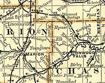
Historical Maps
-
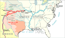
1845 Santa Fe Trail map.
-
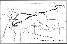
1860 Santa Fe Trail map.
-
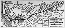
1900-1905 Atchison, Topeka & Santa Fe Railway route map of regular stops.
-
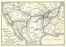
1891 Atchison, Topeka & Santa Fe Railway route map from Grain Dealers and Shippers Gazetteer.
-
1893 railroad map.
-
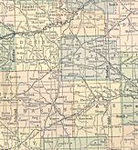
1914 railroad map.
-
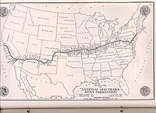
1910s-1920s National Old Trails Road map.
-
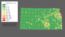
2000 Kansas Population map.


Local Media
Newspapers
- Hillsboro Free Press, for Hillsboro.
- Marion County Record, for Marion.
- Peabody Gazette-Bulletin, for Peabody.
- Hillsboro Star-Journal, for the wider Marion County area.
- The Newton Kansan, a regional newspaper from Newton.
- The Wichita Eagle, a major regional newspaper from Wichita.
See also
 In Spanish: Condado de Marion (Kansas) para niños
