
McPherson County, Kansas facts for kids
Quick facts for kids
McPherson County
|
|
|---|---|
.jpg)
McPherson County Courthouse in McPherson (2023)
|
|

Location within the U.S. state of Kansas
|
|
 Kansas's location within the U.S. |
|
| Country | |
| State | |
| Founded | February 26, 1867 |
| Named for | James B. McPherson |
| Seat | McPherson |
| Largest city | McPherson |
| Area | |
| • Total | 901 sq mi (2,330 km2) |
| • Land | 898 sq mi (2,330 km2) |
| • Water | 2.3 sq mi (6 km2) 0.3%% |
| Population
(2020)
|
|
| • Total | 30,223 |
| • Estimate
()
|
30,091 |
| • Density | 33.7/sq mi (13.0/km2) |
| Time zone | UTC−6 (Central) |
| • Summer (DST) | UTC−5 (CDT) |
| Congressional district | 1st |
McPherson County is a county located in the state of Kansas, United States. Its main city and county seat is McPherson. In 2020, about 30,223 people lived here. The county was named after James B. McPherson, a general who fought in the American Civil War.
Contents
History of McPherson County
Early Days: Land and People
For thousands of years, the Great Plains of North America were home to Native American tribes who moved around a lot. From the 1500s to the 1700s, France claimed a big part of North America. In 1762, after a war, France secretly gave this land to Spain.
In 1803, the United States bought most of the land that is now Kansas from France. This huge purchase was called the Louisiana Purchase. It cost about 2.83 cents for every acre! Later, in 1848, after another war, the U.S. gained more land, including parts of southwest Kansas. In 1854, the Kansas Territory was set up, and in 1861, Kansas became the 34th state.
19th Century: Trails, Towns, and Trains


From the 1820s to the 1870s, the famous Santa Fe Trail passed through what is now McPherson County. This trail was an important route for trade and travel. The first known white settlement in the area was Fuller's Ranch, started in 1855. It offered a place to stay for travelers on the trail.
McPherson County was officially formed in 1867. At first, the county seat was a place called Sweadal. But in 1870, the county leaders decided to move the county seat to the town of McPherson. In 1873, people voted to keep McPherson as the county seat. The town offered free rooms and land to help make this happen.
Railroads were very important in the 1800s. They helped towns grow and made it easier to move goods and people. In 1879, a train line was built from Florence to McPherson. This line later connected many towns, including Marion, Hillsboro, Canton, and Lyons. Another major railroad line, called the "Golden State Route," was built through McPherson County in 1887. It connected places like Herington, Hutchinson, and Pratt.
20th Century: Roads and Progress
In 1912, a major road called the National Old Trails Road was created. It was also known as the Ocean-to-Ocean Highway. This road passed through towns in McPherson County like Windom, Conway, and McPherson. This helped connect the county to other parts of the country by car.
Geography of McPherson County
McPherson County covers about 901 square miles. Most of this is land, with only a small amount (about 0.3%) being water.
Neighboring Counties
McPherson County shares borders with these other counties:
- Saline County (north)
- Dickinson County (northeast)
- Marion County (east)
- Harvey County (southeast)
- Reno County (southwest)
- Rice County (west)
- Ellsworth County (northwest)
Main Roads and Highways
Several important highways run through McPherson County, making it easy to travel:
 Interstate 135
 U.S. Route 56
 U.S. Route 81
 K-4
K-4 K-61
K-61 K-153
K-153
Population and People

| Historical population | |||
|---|---|---|---|
| Census | Pop. | %± | |
| 1870 | 738 | — | |
| 1880 | 17,143 | 2,222.9% | |
| 1890 | 21,614 | 26.1% | |
| 1900 | 21,421 | −0.9% | |
| 1910 | 21,521 | 0.5% | |
| 1920 | 21,845 | 1.5% | |
| 1930 | 23,588 | 8.0% | |
| 1940 | 24,152 | 2.4% | |
| 1950 | 23,670 | −2.0% | |
| 1960 | 24,285 | 2.6% | |
| 1970 | 24,778 | 2.0% | |
| 1980 | 26,855 | 8.4% | |
| 1990 | 27,268 | 1.5% | |
| 2000 | 29,554 | 8.4% | |
| 2010 | 29,180 | −1.3% | |
| 2020 | 30,223 | 3.6% | |
| 2023 (est.) | 30,091 | 3.1% | |
| U.S. Decennial Census 1790-1960 1900-1990 1990-2000 2010-2020 |
|||
McPherson County is part of the McPherson Micropolitan Statistical Area. This means it's a smaller urban area with close ties to the main city.
Education in McPherson County
Colleges and Universities
Students in McPherson County can attend several colleges:
School Districts
Children in the county attend schools in these unified school districts:
- Smoky Valley USD 400
- McPherson USD 418
- Canton-Galva USD 419
- Moundridge USD 423
- Inman USD 448
Some students might also attend schools in districts that have offices in neighboring counties:
- Goessel USD 411
- Little River-Windom USD 444
Museums to Visit
McPherson County has several interesting museums where you can learn about history, art, and more:
- Birger Sandzén Memorial Gallery in Lindsborg
- McCormick-Deering Days Museum in Inman
- McPherson Museum in McPherson
- Lindsborg Old Mill & Swedish Heritage Museum in Lindsborg
- Kansas Motorcycle Museum in Marquette
Communities of McPherson County

McPherson County has several cities, smaller communities, and even some places that used to be towns but are now "ghost towns."
Cities in McPherson County
Smaller Communities (Unincorporated)
These places are not officially cities but are still communities. A "Census-Designated Place" (CDP) means the U.S. Census Bureau counts them as a specific area.
Ghost Towns
These are places that used to be towns but are no longer populated.
- Alta Mills
- Battle Hill
- Christian
- Doles Park
- Elivon
- King City
- Sweadal
Townships in McPherson County
McPherson County is divided into 25 areas called townships. The cities of Lindsborg and McPherson are separate and not included in the township populations. The table below shows information about each township.
| Township | FIPS | Population center |
Population | Population density /km2 (/sq mi) |
Land area km2 (sq mi) |
Water area km2 (sq mi) |
Water % | Geographic coordinates |
|---|---|---|---|---|---|---|---|---|
| Battle Hill | 04550 | 91 | 1 (3) | 93 (36) | 0 (0) | 0.33% | 38°29′2″N 97°25′22″W / 38.48389°N 97.42278°W | |
| Bonaville | 07925 | 66 | 1 (2) | 93 (36) | 0 (0) | 0.34% | 38°32′57″N 97°30′34″W / 38.54917°N 97.50944°W | |
| Canton | 10500 | 1,090 | 12 (30) | 93 (36) | 0 (0) | 0.02% | 38°23′21″N 97°25′36″W / 38.38917°N 97.42667°W | |
| Castle | 10950 | 225 | 2 (6) | 93 (36) | 0 (0) | 0.12% | 38°23′9″N 97°52′44″W / 38.38583°N 97.87889°W | |
| Delmore | 17575 | 138 | 1 (4) | 93 (36) | 0 (0) | 0.15% | 38°28′43″N 97°33′17″W / 38.47861°N 97.55472°W | |
| Empire | 21200 | 1,178 | 13 (33) | 94 (36) | 0 (0) | 0% | 38°23′12″N 97°32′7″W / 38.38667°N 97.53528°W | |
| Groveland | 29150 | 234 | 2 (6) | 94 (36) | 0 (0) | 0.12% | 38°17′55″N 97°44′37″W / 38.29861°N 97.74361°W | |
| Gypsum Creek | 29325 | 215 | 2 (6) | 93 (36) | 0 (0) | 0.11% | 38°33′32″N 97°26′12″W / 38.55889°N 97.43667°W | |
| Harper | 30225 | 137 | 1 (4) | 93 (36) | 0 (0) | 0.17% | 38°28′55″N 97°45′50″W / 38.48194°N 97.76389°W | |
| Hayes | 30950 | 287 | 3 (8) | 94 (36) | 0 (0) | 0% | 38°17′55″N 97°52′54″W / 38.29861°N 97.88167°W | |
| Jackson | 34850 | 198 | 2 (6) | 93 (36) | 0 (0) | 0.49% | 38°22′33″N 97°46′48″W / 38.37583°N 97.78000°W | |
| King City | 36900 | 544 | 6 (15) | 93 (36) | 0 (0) | 0.13% | 38°18′51″N 97°39′8″W / 38.31417°N 97.65222°W | |
| Little Valley | 41600 | 475 | 5 (13) | 93 (36) | 0 (0) | 0.02% | 38°13′38″N 97°52′32″W / 38.22722°N 97.87556°W | |
| Lone Tree | 42525 | 486 | 5 (13) | 94 (36) | 0 (0) | 0% | 38°17′37″N 97°32′48″W / 38.29361°N 97.54667°W | |
| McPherson | 43975 | 618 | 8 (21) | 77 (30) | 0 (0) | 0.23% | 38°23′24″N 97°38′57″W / 38.39000°N 97.64917°W | |
| Marquette | 44950 | 776 | 8 (22) | 93 (36) | 0 (0) | 0.16% | 38°33′9″N 97°51′30″W / 38.55250°N 97.85833°W | |
| Meridian | 45975 | 341 | 4 (9) | 94 (36) | 0 (0) | 0% | 38°12′43″N 97°26′8″W / 38.21194°N 97.43556°W | |
| Mound | 48675 | 2,104 | 23 (59) | 93 (36) | 0 (0) | 0.17% | 38°12′24″N 97°31′22″W / 38.20667°N 97.52278°W | |
| New Gottland | 50350 | 354 | 4 (10) | 93 (36) | 0 (0) | 0.38% | 38°28′29″N 97°38′21″W / 38.47472°N 97.63917°W | |
| Smoky Hill | 66025 | 297 | 3 (9) | 89 (34) | 0 (0) | 0.05% | 38°34′35″N 97°38′59″W / 38.57639°N 97.64972°W | |
| South Sharps Creek | 67000 | 112 | 1 (3) | 93 (36) | 0 (0) | 0.18% | 38°28′21″N 97°52′11″W / 38.47250°N 97.86972°W | |
| Spring Valley | 67750 | 373 | 4 (10) | 94 (36) | 0 (0) | 0.03% | 38°18′2″N 97°25′21″W / 38.30056°N 97.42250°W | |
| Superior | 69475 | 1,640 | 18 (46) | 92 (36) | 1 (0) | 0.72% | 38°13′28″N 97°46′1″W / 38.22444°N 97.76694°W | |
| Turkey Creek | 71700 | 294 | 3 (8) | 93 (36) | 0 (0) | 0% | 38°13′10″N 97°38′23″W / 38.21944°N 97.63972°W | |
| Union | 72225 | 190 | 2 (5) | 93 (36) | 0 (0) | 0.20% | 38°33′12″N 97°44′59″W / 38.55333°N 97.74972°W |
Images for kids
-
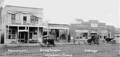
Windom, Kansas in McPherson County during the early 20th century

See also
 In Spanish: Condado de McPherson (Kansas) para niños
