Ellsworth County, Kansas facts for kids
Quick facts for kids
Ellsworth County
|
|
|---|---|

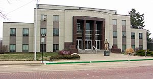
Ellsworth County Courthouse in Ellsworth (2013)
|
|

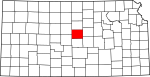
Location within the U.S. state of Kansas
|
|
 Kansas's location within the U.S. |
|
| Country | |
| State | |
| Founded | February 26, 1867 |
| Named for | Fort Ellsworth |
| Seat | Ellsworth |
| Largest city | Ellsworth |
| Area | |
| • Total | 723 sq mi (1,870 km2) |
| • Land | 716 sq mi (1,850 km2) |
| • Water | 7.4 sq mi (19 km2) 1.0%% |
| Population
(2020)
|
|
| • Total | 6,376 |
| • Estimate
(2023)
|
6,357 |
| • Density | 8.9/sq mi (3.4/km2) |
| Time zone | UTC−6 (Central) |
| • Summer (DST) | UTC−5 (CDT) |
| Area code | 785 |
| Congressional district | 1st |
Ellsworth County is a county located in the state of Kansas. Its main city and county seat is Ellsworth. As of the 2020 census, about 6,376 people lived here. The county was named after Fort Ellsworth, an old military base.
Contents
History
Early Land Ownership
For a long time, from the 1500s to the 1700s, France claimed much of North America, including parts of what is now Kansas. In 1762, France secretly gave this land to Spain. Then, in 1802, Spain returned most of it to France.
Just one year later, in 1803, Napoleon of France sold a huge area of land, including modern-day Kansas, to the United States in what was called the Louisiana Purchase. This was a very important event for the growth of the United States.
Becoming a County
In 1854, the Kansas Territory was created. Kansas officially became the 34th U.S. state in 1861.
Ellsworth County was officially formed on February 26, 1867. It was named after Fort Ellsworth, a fort built in 1864 during the American Civil War. The fort was named after Lieutenant Allen Ellsworth, who helped build it. Later, the fort was renamed Fort Harker.
Life in the 1800s
In the late 1800s, this area became known for cattle ranching and cattle drives. Cowboys would bring large herds of cattle through the county. After long journeys, the towns often became lively as cowboys celebrated.
There were also conflicts during this time. In 1869, a group of Pawnee Indians, who had worked for the army, had a fight with U.S. cavalry troops in Ellsworth County. Some Pawnee people died in this conflict.
Geography
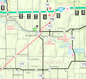
Ellsworth County covers about 723 square miles. Most of this area, about 716 square miles, is land. The rest, about 7.4 square miles, is water. The Smoky Hill River flows through the county.
Neighboring Counties
Ellsworth County shares borders with these other counties:
- Lincoln County (to the north)
- Saline County (to the east)
- McPherson County (to the southeast)
- Rice County (to the south)
- Barton County (to the southwest)
- Russell County (to the northwest)
People and Population
| Historical population | |||
|---|---|---|---|
| Census | Pop. | %± | |
| 1870 | 1,185 | — | |
| 1880 | 8,494 | 616.8% | |
| 1890 | 9,272 | 9.2% | |
| 1900 | 9,626 | 3.8% | |
| 1910 | 10,444 | 8.5% | |
| 1920 | 10,379 | −0.6% | |
| 1930 | 10,132 | −2.4% | |
| 1940 | 9,855 | −2.7% | |
| 1950 | 8,465 | −14.1% | |
| 1960 | 7,677 | −9.3% | |
| 1970 | 6,146 | −19.9% | |
| 1980 | 6,640 | 8.0% | |
| 1990 | 6,586 | −0.8% | |
| 2000 | 6,525 | −0.9% | |
| 2010 | 6,497 | −0.4% | |
| 2020 | 6,376 | −1.9% | |
| 2023 (est.) | 6,357 | −2.2% | |
| U.S. Decennial Census 1790-1960 1900-1990 1990-2000 2010-2020 |
|||
As of the 2000 census, there were 6,525 people living in Ellsworth County. The population density was about 9 people per square mile. Most people (over 93%) identified as White. About 3.5% were Black or African American, and about 3.6% were of Hispanic or Latino background.
The population was spread out in terms of age. About 21% of the people were under 18 years old. About 20% were 65 years or older. The average age in the county was 42 years.
Education
Ellsworth County has a few school districts that serve its communities:
Unified School Districts
- Central Plains USD 112
- Ellsworth USD 327
Communities
Ellsworth County is home to several cities, smaller communities, and even some places that used to be towns but are now "ghost towns."
Cities
Unincorporated Communities
These are smaller communities that are not officially organized as cities:
- Black Wolf
- Carneiro
- Delight
- Elkhorn
- Langley
- Venango
- Yankee Run
Ghost Towns
These places used to be towns but are now abandoned:
- Arcola
- Terra Cotta
- Frantz
- Midway
See also
 In Spanish: Condado de Ellsworth para niños
 | William M. Jackson |
 | Juan E. Gilbert |
 | Neil deGrasse Tyson |


