Saline County, Kansas facts for kids
Quick facts for kids
Saline County
|
|
|---|---|
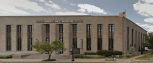
Smoky Hills Museum in Salina (2013)
|
|
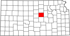
Location within the U.S. state of Kansas
|
|
 Kansas's location within the U.S. |
|
| Country | |
| State | |
| Founded | February 15, 1860 |
| Named for | Saline River |
| Seat | Salina |
| Largest city | Salina |
| Area | |
| • Total | 721 sq mi (1,870 km2) |
| • Land | 720 sq mi (1,900 km2) |
| • Water | 1.1 sq mi (3 km2) 0.2% |
| Population
(2020)
|
|
| • Total | 54,303 |
| • Estimate
(2023)
|
53,098 |
| • Density | 75.4/sq mi (29.1/km2) |
| Time zone | UTC−6 (Central) |
| • Summer (DST) | UTC−5 (CDT) |
| Congressional district | 1st |
Saline County is a county located in the state of Kansas in the United States. Its main city and where the county government is located is Salina. In 2020, about 54,303 people lived in Saline County. The county got its name from the Saline River.
Contents
History
Early Days of Kansas
For thousands of years, the Great Plains of North America were home to different groups of Native Americans.
From the 1500s to the 1700s, France claimed a lot of land in North America. In 1762, after a big war, France secretly gave this land to Spain. But in 1802, Spain gave most of it back to France.
In 1803, the United States bought a huge amount of land from France. This was called the Louisiana Purchase. Most of what is now Kansas was part of this deal. Later, in 1848, after another war, more land was added to the U.S., including parts of southwest Kansas.
In 1854, the area was officially set up as the Kansas Territory. Then, in 1861, Kansas became the 34th state in the U.S.
1800s in Saline County
Saline County was officially created in 1860.
1900s in Saline County
For a long time, Saline County was a "dry" county. This meant that selling alcoholic drinks was not allowed. This rule changed in 1986 when people voted to allow alcohol sales in restaurants. Later, in 1994, another vote removed the rule that restaurants had to sell a certain amount of food with alcohol.
Geography
Saline County covers a total area of about 721 square miles. Most of this land is dry, with only a small part (about 1.1 square miles) being water.
Neighboring Counties
Saline County shares its borders with several other counties:
- Ottawa County to the north
- Dickinson County to the east
- Marion County to the southeast
- McPherson County to the south
- Ellsworth County to the west
- Lincoln County to the northwest
People of Saline County
| Historical population | |||
|---|---|---|---|
| Census | Pop. | %± | |
| 1870 | 4,246 | — | |
| 1880 | 13,808 | 225.2% | |
| 1890 | 17,442 | 26.3% | |
| 1900 | 17,076 | −2.1% | |
| 1910 | 20,338 | 19.1% | |
| 1920 | 25,103 | 23.4% | |
| 1930 | 29,337 | 16.9% | |
| 1940 | 29,535 | 0.7% | |
| 1950 | 33,409 | 13.1% | |
| 1960 | 54,715 | 63.8% | |
| 1970 | 46,592 | −14.8% | |
| 1980 | 48,905 | 5.0% | |
| 1990 | 49,301 | 0.8% | |
| 2000 | 53,597 | 8.7% | |
| 2010 | 55,606 | 3.7% | |
| 2020 | 54,303 | −2.3% | |
| 2023 (est.) | 53,098 | −4.5% | |
| U.S. Decennial Census 1790-1960 1900-1990 1990-2000 2010-2020 |
|||
Saline County is part of the Salina Micropolitan Statistical Area. This means that Salina is a central city for the smaller towns and areas around it.
Education
Colleges and Universities
Students in Saline County have several options for higher education:
- Kansas State University Polytechnic Campus in Salina
- Kansas Wesleyan University in Salina
- Salina Area Technical College in Salina
School Districts
These are the main school districts that serve students in Saline County:
- Salina USD 305
- Southeast of Saline USD 306
- Ell-Saline USD 307
Some school district offices are located in neighboring counties but also serve parts of Saline County:
- Twin Valley USD 240
- Solomon USD 393
- Smoky Valley USD 400
Private Schools
There are also private school options in the county:
- St. John's Military School
- Sacred Heart High School
Communities
Saline County has several cities and smaller communities.
Cities
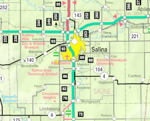
- Assaria
- Brookville
- Gypsum
- New Cambria
- Salina (This is the county seat)
- Smolan
- Solomon‡ (Some parts of Solomon are in another county)
Unincorporated Communities
These are smaller towns or areas that are not officially organized as cities:
- Bavaria† (This is a Census-Designated Place, meaning it's a recognized community for census purposes)
- Bridgeport†
- Falun†
- Glendale
- Hedville
- Kipp†
- Mentor†
- Salemsborg
- Shipton
- Trenton
Townships
Saline County is divided into eighteen smaller areas called townships. The city of Salina is separate and not included in the township numbers.
Images for kids
See also
 In Spanish: Condado de Saline (Kansas) para niños
 | Roy Wilkins |
 | John Lewis |
 | Linda Carol Brown |


