
Ottawa County, Kansas facts for kids
Quick facts for kids
Ottawa County
|
|
|---|---|

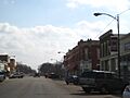
Downtown Minneapolis (2009)
|
|

Location within the U.S. state of Kansas
|
|
 Kansas's location within the U.S. |
|
| Country | |
| State | |
| Founded | February 27, 1860 |
| Named for | Odawa tribe |
| Seat | Minneapolis |
| Largest city | Minneapolis |
| Area | |
| • Total | 721 sq mi (1,870 km2) |
| • Land | 721 sq mi (1,870 km2) |
| • Water | 0.6 sq mi (2 km2) 0.08%% |
| Population
(2020)
|
|
| • Total | 5,735 |
| • Density | 8.0/sq mi (3.1/km2) |
| Time zone | UTC−6 (Central) |
| • Summer (DST) | UTC−5 (CDT) |
| Congressional district | 1st |
Ottawa County is a place in the state of Kansas. The main town and biggest city is Minneapolis. In 2020, about 5,735 people lived here. The county got its name from the Odawa tribe.
Contents
History of Ottawa County
Early Days
For thousands of years, Native American tribes lived on the Great Plains of North America. They often moved around, following animals and seasons.
From the 1500s to the 1700s, France said they owned much of North America. After a war in 1762, France secretly gave this land to Spain.
The 1800s
In 1802, Spain gave most of the land back to France. Then, in 1803, the United States bought a huge area from France. This was part of the Louisiana Purchase. Most of what is now Kansas was included in this deal.
In 1854, the Kansas Territory was created. Kansas officially became the 34th U.S. state in 1861. Ottawa County was started in 1860.
The 1900s
For many years, Ottawa County had rules against selling alcohol. This was called being a "dry county." In 2006, people voted to allow restaurants to sell alcoholic drinks with meals.
Geography of Ottawa County
Ottawa County covers about 721 square miles. Most of this is land, with only a tiny bit being water.
Rivers and Lakes
The Solomon River is the longest river in Ottawa County. It flows into the county from Cloud County and leaves towards Saline County. The Saline River also crosses the southwestern part of the county.
The biggest lake is Ottawa State Fishing Lake. It's a 111-acre lake east of Minneapolis. The Kansas Department of Wildlife and Parks takes care of it.
Neighboring Counties
Ottawa County shares borders with these counties:
- Cloud County (north)
- Clay County (northeast)
- Dickinson County (southeast)
- Saline County (south)
- Lincoln County (west)
- Mitchell County (northwest)
People of Ottawa County

Ottawa County is part of the Salina area.
In 2000, there were 6,163 people living in the county. Most people were White (about 97.5%). A small number were Black, Native American, or Asian. About 1.3% of the people were Hispanic or Latino.
The average age in the county was 40 years old. About 25.7% of the people were under 18.
Education in Ottawa County
School Districts
Students in Ottawa County go to schools in these districts:
- North Ottawa County USD 239
- Twin Valley USD 240
Communities in Ottawa County

Here are the towns and communities in Ottawa County:
Cities
- Bennington
- Culver
- Delphos
- Minneapolis (This is the county seat, or main town)
- Tescott
Unincorporated Communities
These are smaller communities that are not officially cities. Some are called Census-Designated Places (CDP) by the U.S. Census Bureau.
Ghost Town
- Vine Creek (This town no longer exists)
Townships

Ottawa County is divided into twenty smaller areas called townships. The city of Minneapolis is separate from these townships for government purposes.
| Township | Population | Population density /sq mi |
Land area sq mi |
Water area sq mi |
|---|---|---|---|---|
| Bennington | 1,116 | 27 | 42 | 0 |
| Blaine | 111 | 3 | 36 | 0 |
| Buckeye | 101 | 3 | 30 | 0 |
| Center | 72 | 2 | 36 | 0 |
| Chapman | 67 | 2 | 36 | 0 |
| Concord | 209 | 6 | 35 | 0 |
| Culver | 318 | 9 | 36 | 0 |
| Durham | 25 | 1 | 36 | 0 |
| Fountain | 190 | 5 | 36 | 0 |
| Garfield | 95 | 3 | 36 | 0 |
| Grant | 93 | 3 | 36 | 0 |
| Henry | 22 | 1 | 36 | 0 |
| Lincoln | 143 | 4 | 36 | 0 |
| Logan | 82 | 2 | 36 | 0 |
| Morton | 498 | 14 | 36 | 0 |
| Ottawa | 49 | 1 | 36 | 0 |
| Richland | 218 | 6 | 36 | 0 |
| Sheridan | 589 | 16 | 36 | 0 |
| Sherman | 67 | 2 | 36 | 0 |
| Stanton | 52 | 1 | 37 | 0 |
Images for kids
-
Downtown Minneapolis (2009)
See also
 In Spanish: Condado de Ottawa (Kansas) para niños
