Minneapolis, Kansas facts for kids
Quick facts for kids
Minneapolis, Kansas
|
|
|---|---|
|
City and County seat
|
|

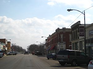
Business District (2009)
|
|

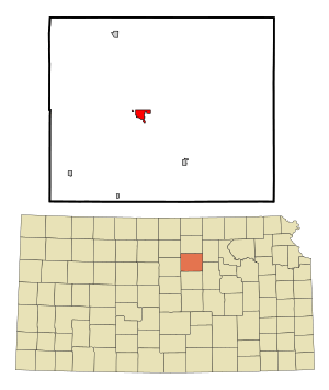
Location within Ottawa County and Kansas
|
|

|
|
| Country | United States |
| State | Kansas |
| County | Ottawa |
| Founded | 1860s |
| Platted | 1866 |
| Incorporated | 1871 |
| Named for | Minneapolis, Minnesota |
| Area | |
| • Total | 1.83 sq mi (4.75 km2) |
| • Land | 1.83 sq mi (4.75 km2) |
| • Water | 0.00 sq mi (0.00 km2) |
| Elevation | 1,276 ft (389 m) |
| Population
(2020)
|
|
| • Total | 1,946 |
| • Density | 1,063/sq mi (409.7/km2) |
| Time zone | UTC-6 (CST) |
| • Summer (DST) | UTC-5 (CDT) |
| ZIP code |
67467
|
| Area code | 785 |
| FIPS code | 20-47075 |
| GNIS ID | 485622 |
Minneapolis is a city in Kansas, United States. It is the main city and the "county seat" of Ottawa County. A county seat is like the capital city of a county. In 2020, about 1,946 people lived in Minneapolis.
Contents
History of Minneapolis
The area where Minneapolis now stands was first called Markley's Mills. This name was given in 1866 when the town was first planned.
Around 1871, the town changed its name to Minneapolis. It was named after the larger city of Minneapolis, Minnesota. A railroad line was built through Minneapolis in 1878. This helped the town grow and connect with other places.
Sports History: Baseball Teams
Minneapolis even had its own minor league baseball team! They were called the Minnies. They played in 1905, and then again from 1908 to 1909, and one more time in 1912. They were part of different baseball leagues, like the Kansas State League.
Geography and Climate
Minneapolis is located in Kansas. According to the United States Census Bureau, the city covers about 1.76 square miles (4.56 square kilometers) of land. There is no water area within the city limits.
Minneapolis Weather and Temperatures
The weather in Minneapolis, Kansas, changes a lot throughout the year. Summers are usually hot, and winters can be cold. The city gets a good amount of rain, especially in spring and summer. Snowfall happens mostly in the winter months.
| Climate data for Minneapolis, Kansas (1991–2020 normals, extremes 1892–present) | |||||||||||||
|---|---|---|---|---|---|---|---|---|---|---|---|---|---|
| Month | Jan | Feb | Mar | Apr | May | Jun | Jul | Aug | Sep | Oct | Nov | Dec | Year |
| Record high °F (°C) | 80 (27) |
87 (31) |
95 (35) |
101 (38) |
104 (40) |
113 (45) |
117 (47) |
119 (48) |
115 (46) |
102 (39) |
87 (31) |
82 (28) |
119 (48) |
| Mean maximum °F (°C) | 64.5 (18.1) |
71.1 (21.7) |
80.8 (27.1) |
87.8 (31.0) |
92.8 (33.8) |
99.3 (37.4) |
104.9 (40.5) |
102.9 (39.4) |
97.5 (36.4) |
89.6 (32.0) |
75.6 (24.2) |
64.4 (18.0) |
105.9 (41.1) |
| Mean daily maximum °F (°C) | 40.4 (4.7) |
45.8 (7.7) |
57.0 (13.9) |
67.1 (19.5) |
76.7 (24.8) |
87.7 (30.9) |
93.3 (34.1) |
90.6 (32.6) |
82.6 (28.1) |
69.6 (20.9) |
55.0 (12.8) |
42.6 (5.9) |
67.4 (19.7) |
| Daily mean °F (°C) | 29.3 (−1.5) |
33.5 (0.8) |
43.8 (6.6) |
53.9 (12.2) |
64.7 (18.2) |
75.4 (24.1) |
80.8 (27.1) |
78.1 (25.6) |
69.7 (20.9) |
56.5 (13.6) |
42.8 (6.0) |
31.9 (−0.1) |
55.0 (12.8) |
| Mean daily minimum °F (°C) | 18.2 (−7.7) |
21.3 (−5.9) |
30.6 (−0.8) |
40.7 (4.8) |
52.7 (11.5) |
63.2 (17.3) |
68.2 (20.1) |
65.6 (18.7) |
56.8 (13.8) |
43.4 (6.3) |
30.6 (−0.8) |
21.3 (−5.9) |
42.7 (5.9) |
| Mean minimum °F (°C) | 1.0 (−17.2) |
4.8 (−15.1) |
13.4 (−10.3) |
26.2 (−3.2) |
38.3 (3.5) |
51.0 (10.6) |
58.0 (14.4) |
56.2 (13.4) |
41.8 (5.4) |
27.6 (−2.4) |
15.4 (−9.2) |
5.2 (−14.9) |
−3.3 (−19.6) |
| Record low °F (°C) | −22 (−30) |
−29 (−34) |
−13 (−25) |
8 (−13) |
21 (−6) |
40 (4) |
48 (9) |
41 (5) |
28 (−2) |
10 (−12) |
−4 (−20) |
−24 (−31) |
−29 (−34) |
| Average precipitation inches (mm) | 0.86 (22) |
1.16 (29) |
1.92 (49) |
2.42 (61) |
5.17 (131) |
3.98 (101) |
4.40 (112) |
4.20 (107) |
2.69 (68) |
2.39 (61) |
1.24 (31) |
1.29 (33) |
31.72 (806) |
| Average snowfall inches (cm) | 4.7 (12) |
3.4 (8.6) |
2.2 (5.6) |
0.9 (2.3) |
0.0 (0.0) |
0.0 (0.0) |
0.0 (0.0) |
0.0 (0.0) |
0.0 (0.0) |
0.3 (0.76) |
1.6 (4.1) |
4.5 (11) |
17.6 (45) |
| Average precipitation days (≥ 0.01 in) | 5.3 | 5.8 | 7.7 | 8.9 | 11.3 | 9.3 | 9.8 | 10.0 | 7.3 | 6.9 | 6.0 | 5.6 | 93.9 |
| Average snowy days (≥ 0.1 in) | 3.8 | 2.8 | 1.9 | 0.5 | 0.0 | 0.0 | 0.0 | 0.0 | 0.0 | 0.3 | 1.4 | 3.0 | 13.7 |
| Source: NOAA | |||||||||||||
People of Minneapolis
Minneapolis is part of the Salina area, which is a group of nearby towns. The city's population has changed over the years.
| Historical population | |||
|---|---|---|---|
| Census | Pop. | %± | |
| 1880 | 1,084 | — | |
| 1890 | 1,756 | 62.0% | |
| 1900 | 1,727 | −1.7% | |
| 1910 | 1,895 | 9.7% | |
| 1920 | 1,842 | −2.8% | |
| 1930 | 1,741 | −5.5% | |
| 1940 | 2,087 | 19.9% | |
| 1950 | 1,801 | −13.7% | |
| 1960 | 2,024 | 12.4% | |
| 1970 | 1,971 | −2.6% | |
| 1980 | 2,075 | 5.3% | |
| 1990 | 1,983 | −4.4% | |
| 2000 | 2,046 | 3.2% | |
| 2010 | 2,032 | −0.7% | |
| 2020 | 1,946 | −4.2% | |
| U.S. Decennial Census | |||
2020 Population Details
In 2020, Minneapolis had 1,946 people living in 785 households. A household is a group of people living together. The city had about 1,061 people per square mile.
Most people in Minneapolis (about 92%) were White. A smaller number were African American, Native American, Asian, or from other backgrounds. About 6% of people were from two or more races. About 3% of the population was Hispanic or Latino.
- About 27% of households had children under 18.
- Nearly half (49.7%) were married couples.
- About 35% of households had just one person living there.
- The average age in Minneapolis was 42.2 years old.
- About 24% of the population was under 18.
- About 22% of people were 65 or older.
The average income for a household was about $52,578 per year. For families, it was about $76,719 per year. About 11.6% of all people in Minneapolis lived below the poverty line. This means their income was below a certain level.
2010 Population Details
In 2010, there were 2,032 people living in Minneapolis. There were 832 households. The city had about 1,154 people per square mile.
- Most people (96.1%) were White.
- About 1.2% were African American.
- About 2.7% of the population was Hispanic or Latino.
- About 32% of households had children under 18.
- About 48% were married couples.
- About 33% of households had one person living alone.
- The average age in the city was 40 years.
- About 26% of residents were under 18.
- About 20% were 65 or older.
Fun Places to Visit

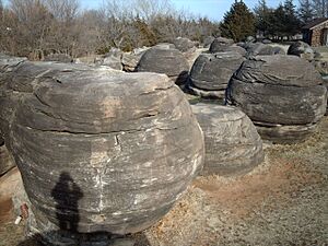
One cool place near Minneapolis is Rock City. It is a park located about 3 miles southwest of the city. Rock City is famous for its huge, round sandstone boulders. These rocks were formed naturally over millions of years. It's a great spot to explore and see unique rock formations.
Education in Minneapolis
Students in Minneapolis attend public schools run by the North Ottawa County USD 239 school district. This district provides education for children in the area.
Famous People from Minneapolis
Many interesting people have connections to Minneapolis:
- George Washington Carver: A famous scientist and inventor who lived near Minneapolis for a short time.
- Bessie S. McColgin: An Oklahoma businesswoman and politician.
- Rollin Rees: He used to be a U.S. Representative for Kansas. This means he was elected to represent Kansas in the United States government.
- Frank "Cannonball" Richards: A performer known for his amazing acts where he would get hit in the stomach, even with a cannonball!
- Alexander Riddle: He was the 11th Lieutenant Governor of Kansas. He also published the local newspaper, the Minneapolis Messenger.
See also
 In Spanish: Minneapolis (Kansas) para niños
 | Jessica Watkins |
 | Robert Henry Lawrence Jr. |
 | Mae Jemison |
 | Sian Proctor |
 | Guion Bluford |

