Dickinson County, Kansas facts for kids
Quick facts for kids
Dickinson County
|
|
|---|---|
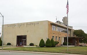
Dickinson County Courthouse in Abilene (2009)
|
|
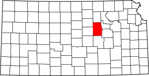
Location within the U.S. state of Kansas
|
|
 Kansas's location within the U.S. |
|
| Country | |
| State | |
| Founded | February 20, 1857 |
| Named for | Daniel S. Dickinson |
| Seat | Abilene |
| Largest city | Abilene |
| Area | |
| • Total | 852 sq mi (2,210 km2) |
| • Land | 847 sq mi (2,190 km2) |
| • Water | 4.9 sq mi (13 km2) 0.6%% |
| Population
(2020)
|
|
| • Total | 18,402 |
| • Estimate
(2023)
|
18,445 |
| • Density | 21.7/sq mi (8.4/km2) |
| Time zone | UTC−6 (Central) |
| • Summer (DST) | UTC−5 (CDT) |
| Area code | 785 |
| Congressional district | 1st |
Dickinson County is a county located in the middle of Kansas. Its main city and county seat is Abilene. In 2020, about 18,402 people lived here. The county was named after Daniel S. Dickinson, a U.S. Senator from New York. He supported Kansas becoming a state.
Contents
History
Early Kansas History
For thousands of years, the Great Plains of North America were home to nomadic Native American tribes.
From the 16th to 18th centuries, France claimed much of North America. In 1762, after a war, France secretly gave New France to Spain. In 1802, Spain gave most of this land back to France.
In 1803, the United States bought most of the land that is now Kansas from France. This was part of the huge Louisiana Purchase. In 1854, the Kansas Territory was created. Then, in 1861, Kansas officially became the 34th U.S. state.
19th Century in Dickinson County
Dickinson County was founded in 1857.
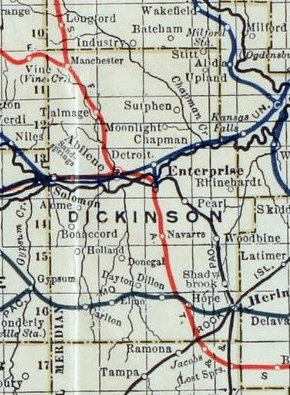
The first railroad tracks were built through Dickinson County in 1866. Railroads were very important for moving people and goods.
In 1887, a man named Mr. Herington helped the Chicago, Kansas and Nebraska Railway build tracks through Herington. He gave land for the railroad to build shops, depots, and other buildings. This made Herington an important railroad center.
Many railroad lines were built during this time. For example, a main line connected Topeka to Herington. Another line went from Herington all the way to Pratt and later even to Tucumcari, New Mexico and El Paso, Texas. This route was known as the "Golden State Limited."
Another branch line went from Herington south to Caldwell. This line eventually reached Fort Worth, Texas and was called the "OKT."
Over the years, these railroad companies changed names and merged. The Chicago, Kansas and Nebraska Railway became part of the Chicago, Rock Island and Pacific Railway. Today, most locals still call it the "Rock Island."
In 1887, the Atchison, Topeka and Santa Fe Railway also built a line through the county. It connected places like Abilene and Enterprise to other towns. This line was often called the "Strong City line."
In 1996, the Atchison, Topeka and Santa Fe Railway merged with another company to become the BNSF Railway. People in the area often still call it the "Santa Fe."
21st Century
In 2010, the Keystone-Cushing Pipeline was built through Dickinson County. This pipeline carries oil. There was some discussion about its taxes and environmental effects. A pumping station for the pipeline was built near the town of Hope.
Geography
Dickinson County covers about 852 square miles. Most of this area, about 847 square miles, is land. The rest, about 4.9 square miles, is water.
Neighboring Counties
- Clay County (north)
- Geary County (east)
- Morris County (southeast)
- Marion County (south)
- McPherson County (southwest)
- Saline County (west)
- Ottawa County (northwest)
Demographics
| Historical population | |||
|---|---|---|---|
| Census | Pop. | %± | |
| 1860 | 378 | — | |
| 1870 | 3,043 | 705.0% | |
| 1880 | 15,251 | 401.2% | |
| 1890 | 22,273 | 46.0% | |
| 1900 | 21,816 | −2.1% | |
| 1910 | 24,361 | 11.7% | |
| 1920 | 25,777 | 5.8% | |
| 1930 | 25,870 | 0.4% | |
| 1940 | 22,929 | −11.4% | |
| 1950 | 21,190 | −7.6% | |
| 1960 | 21,572 | 1.8% | |
| 1970 | 19,993 | −7.3% | |
| 1980 | 20,175 | 0.9% | |
| 1990 | 18,958 | −6.0% | |
| 2000 | 19,344 | 2.0% | |
| 2010 | 19,754 | 2.1% | |
| 2020 | 18,402 | −6.8% | |
| 2023 (est.) | 18,445 | −6.6% | |
| U.S. Decennial Census 1790-1960 1900-1990 1990-2000 2010-2020 |
|||
Education
School Districts
Here are the school districts that serve students in Dickinson County:
- Solomon USD 393
- Abilene USD 435
- Chapman USD 473
- Herington USD 487
Some school district offices are in nearby counties but still serve parts of Dickinson County:
- Centre USD 397
- Rural Vista USD 481
- Southeast of Saline USD 306
Communities
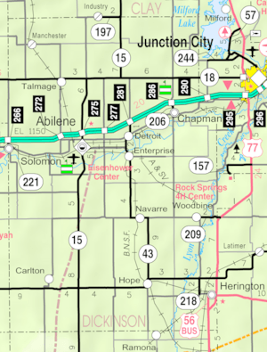
Dickinson County has several cities, small communities, and townships.
Cities
‡ means a city also extends into a neighboring county.
- Abilene (county seat)
- Carlton
- Chapman
- Enterprise
- Herington‡
- Hope
- Manchester
- Solomon‡
- Woodbine
Unincorporated Communities
† means this community is recognized as a Census-Designated Place (CDP).
Townships
Dickinson County is divided into 24 areas called townships. The cities of Abilene and Herington are separate and not included in the township populations. The table below shows information about each township.
| Township | FIPS | Population center |
Population | Population density /km2 (/sq mi) |
Land area km2 (sq mi) |
Water area km2 (sq mi) |
Water % | Geographic coordinates |
|---|---|---|---|---|---|---|---|---|
| Banner | 03975 | 148 | 2 (4) | 92 (35) | 1 (0) | 0.62% | 38°39′37″N 97°11′50″W / 38.66028°N 97.19722°W | |
| Buckeye | 08925 | 437 | 5 (12) | 94 (36) | 0 (0) | 0.15% | 38°59′1″N 97°12′58″W / 38.98361°N 97.21611°W | |
| Center | 11675 | 1,210 | 13 (34) | 92 (35) | 2 (1) | 2.16% | 38°54′32″N 97°6′21″W / 38.90889°N 97.10583°W | |
| Cheever | 12700 | 149 | 2 (4) | 93 (36) | 0 (0) | 0.04% | 39°5′58″N 97°11′42″W / 39.09944°N 97.19500°W | |
| Flora | 23550 | 217 | 2 (6) | 93 (36) | 0 (0) | 0.08% | 39°5′12″N 97°19′4″W / 39.08667°N 97.31778°W | |
| Fragrant Hill | 24250 | 251 | 3 (8) | 77 (30) | 0 (0) | 0.21% | 39°4′54″N 97°0′34″W / 39.08167°N 97.00944°W | |
| Garfield | 25550 | 189 | 2 (5) | 94 (36) | 0 (0) | 0.06% | 38°49′22″N 97°18′43″W / 38.82278°N 97.31194°W | |
| Grant | 27625 | 918 | 11 (29) | 82 (32) | 1 (1) | 1.58% | 38°54′42″N 97°12′22″W / 38.91167°N 97.20611°W | |
| Hayes | 30900 | 233 | 3 (8) | 78 (30) | 0 (0) | 0.04% | 38°59′43″N 97°6′8″W / 38.99528°N 97.10222°W | |
| Holland | 32625 | 107 | 1 (3) | 93 (36) | 0 (0) | 0.17% | 38°40′19″N 97°18′39″W / 38.67194°N 97.31083°W | |
| Hope | 33100 | 519 | 6 (15) | 92 (35) | 0 (0) | 0.45% | 38°39′36″N 97°5′13″W / 38.66000°N 97.08694°W | |
| Jefferson | 35175 | 166 | 2 (5) | 94 (36) | 0 (0) | 0.46% | 38°44′1″N 97°11′45″W / 38.73361°N 97.19583°W | |
| Liberty | 40000 | 405 | 4 (9) | 114 (44) | 0 (0) | 0.11% | 38°49′11″N 96°57′35″W / 38.81972°N 96.95972°W | |
| Lincoln | 40625 | 1,669 | 18 (46) | 93 (36) | 2 (1) | 1.99% | 38°54′51″N 97°20′46″W / 38.91417°N 97.34611°W | |
| Logan | 41850 | 202 | 2 (6) | 94 (36) | 0 (0) | 0.23% | 38°49′12″N 97°5′3″W / 38.82000°N 97.08417°W | |
| Lyon | 43475 | 252 | 3 (8) | 86 (33) | 1 (0) | 0.98% | 38°39′32″N 96°59′20″W / 38.65889°N 96.98889°W | |
| Newbern | 50225 | 349 | 4 (10) | 94 (36) | 0 (0) | 0.14% | 38°50′6″N 97°11′43″W / 38.83500°N 97.19528°W | |
| Noble | 50800 | 1,730 | 21 (55) | 81 (31) | 1 (0) | 1.29% | 38°58′59″N 97°0′23″W / 38.98306°N 97.00639°W | |
| Ridge | 59800 | 160 | 2 (4) | 94 (36) | 0 (0) | 0.43% | 38°44′14″N 97°5′0″W / 38.73722°N 97.08333°W | |
| Rinehart | 59900 | 194 | 2 (5) | 93 (36) | 0 (0) | 0.40% | 38°55′18″N 96°59′30″W / 38.92167°N 96.99167°W | |
| Sherman | 64925 | 147 | 2 (5) | 78 (30) | 0 (0) | 0% | 39°5′6″N 97°6′10″W / 39.08500°N 97.10278°W | |
| Union | 72100 | 176 | 2 (5) | 94 (36) | 0 (0) | 0.20% | 38°43′38″N 96°58′14″W / 38.72722°N 96.97056°W | |
| Wheatland | 77625 | 152 | 2 (4) | 93 (36) | 0 (0) | 0.18% | 38°43′59″N 97°18′27″W / 38.73306°N 97.30750°W | |
| Willowdale | 79450 | 258 | 3 (7) | 93 (36) | 0 (0) | 0.05% | 38°59′41″N 97°18′7″W / 38.99472°N 97.30194°W | |
| Sources: | ||||||||
Points of Interest
The Eisenhower Library is located in Abilene. This special place has exhibits about the life and presidency of Dwight D. Eisenhower, who was the 34th U.S. President. It is also where President Eisenhower, his wife Mamie, and their son are buried.
Notable People
Dwight David "Ike" Eisenhower was born in Texas but grew up in Abilene, Kansas, and considered it his home. He served as the 34th President of the United States from 1953 to 1961. Before becoming president, he was a very important five-star general in the United States Army. During World War II, he was the Supreme Commander of the Allied Forces in Europe. He planned and led major invasions like Operation Torch in North Africa and the invasion of France and Germany. After the war, he became the first supreme commander of NATO in 1951. You can learn more about him at the Eisenhower Library in Abilene.
Joe Engle is a retired U.S. Air Force colonel and a former NASA astronaut. He helped test the X-15 rocket airplane, earning his astronaut wings and other awards. He was one of the first astronauts in the Space Shuttle program. He even helped test the Space Shuttle Enterprise in 1977 and commanded the second test flight of the Space Shuttle Columbia in 1981. Joe Engle was born and raised in Chapman, Kansas.
Pop Hollinger was a pioneer in collecting comic books. He also held several patents for his inventions. He grew up in Chapman.
See also
 In Spanish: Condado de Dickinson (Kansas) para niños
 | Chris Smalls |
 | Fred Hampton |
 | Ralph Abernathy |


