
Tucumcari, New Mexico facts for kids
Quick facts for kids
Tucumcari, New Mexico
|
||
|---|---|---|

Quay County Courthouse in 2008
|
||
|
||

Location of Tucumcari in New Mexico
|
||

Tucumcari, New Mexico
Location in the United States
|
||
| Country | United States | |
| State | New Mexico | |
| County | Quay | |
| Founded | 1901 | |
| Area | ||
| • Total | 9.51 sq mi (24.63 km2) | |
| • Land | 9.51 sq mi (24.62 km2) | |
| • Water | 0.00 sq mi (0.00 km2) | |
| Elevation | 4,032 ft (1,229 m) | |
| Population
(2020)
|
||
| • Total | 5,278 | |
| • Density | 555.17/sq mi (214.34/km2) | |
| Time zone | UTC−7 (MST) | |
| • Summer (DST) | UTC−6 (MDT) | |
| ZIP code |
88401
|
|
| Area code(s) | 575 | |
| FIPS code | 35-79910 | |
| GNIS feature ID | 2412105 | |
| Website | City Website | |
Tucumcari (pronounced too-CUM-carry) is a city in Quay County, New Mexico, United States. It is also the county seat, which means it is where the local government is located. In 2020, about 5,278 people lived there. Tucumcari was started in 1901, two years before Quay County was officially created.
Contents
History of Tucumcari
.jpg)
In 1901, a railroad company called the Chicago, Rock Island and Pacific Railroad set up a work camp in the area. This camp was first called Ragtown. Later, it became known as "Six Shooter Siding" because there were many gunfights.
Its first official name was Douglas, but that name didn't last long. As the camp grew into a real town, it was renamed Tucumcari in 1908. The town got its name from Tucumcari Mountain, which is close by.
No one is completely sure where the mountain's name came from. It might come from a Comanche word, tʉkamʉkarʉ, which means 'ambush'. An old record from 1777 talks about a Comanche woman and her child captured in a battle at a place called Cuchuncari. Many believe this was an early version of the name Tucumcari.
Tucumcari as a Railroad Hub
Until the mid-1900s, Tucumcari was an important stop for trains traveling across the country. The Rock Island Railroad and the Southern Pacific railroad lines met here. Passengers could switch trains at the station for different parts of their journey.
For example, the Choctaw Rocket train, which traveled from Memphis to Los Angeles, would stop here. The Golden State train, going from Chicago to Los Angeles, also passed right through Tucumcari.
Large Cattle Ranches Nearby
Tucumcari is also known for being close to some very large cattle ranches.
- Bell Ranch - This ranch was started in 1824 and is one of the biggest ranches in the United States today.
- T4 Cattle Company - Founded in 1902, this ranch is still run by the same family and is one of the country's largest.
Geography and Climate
Tucumcari is located in New Mexico. The city covers about 9.5 square miles (24.6 square kilometers) of land. There is very little water area within the city limits.
Tucumcari's Climate
Tucumcari has a cool semi-arid climate. This means it has cool winters and hot summers. It doesn't get a lot of rain, except during the summer. In summer, thunderstorms from the North American monsoon can bring heavy rain.
Snowfall is usually light, with about 14.9 inches (38 cm) per year. Because the air is often dry, the temperature can change a lot between day and night.
The hottest temperature ever recorded in Tucumcari was 111°F (44°C) on June 11, 2022. The coldest was -22°F (-30°C) on January 13, 1963.
| Climate data for Tucumcari, New Mexico, 1991–2020 normals, extremes 1904–present | |||||||||||||
|---|---|---|---|---|---|---|---|---|---|---|---|---|---|
| Month | Jan | Feb | Mar | Apr | May | Jun | Jul | Aug | Sep | Oct | Nov | Dec | Year |
| Record high °F (°C) | 80 (27) |
87 (31) |
92 (33) |
97 (36) |
103 (39) |
111 (44) |
110 (43) |
108 (42) |
105 (41) |
97 (36) |
90 (32) |
82 (28) |
111 (44) |
| Mean maximum °F (°C) | 72.1 (22.3) |
76.9 (24.9) |
84.4 (29.1) |
89.3 (31.8) |
95.8 (35.4) |
103.5 (39.7) |
103.8 (39.9) |
101.4 (38.6) |
98.0 (36.7) |
90.8 (32.7) |
81.1 (27.3) |
73.2 (22.9) |
105.7 (40.9) |
| Mean daily maximum °F (°C) | 53.4 (11.9) |
57.9 (14.4) |
65.7 (18.7) |
73.3 (22.9) |
82.0 (27.8) |
92.0 (33.3) |
94.5 (34.7) |
92.3 (33.5) |
85.5 (29.7) |
74.6 (23.7) |
62.6 (17.0) |
53.4 (11.9) |
73.9 (23.3) |
| Daily mean °F (°C) | 39.0 (3.9) |
43.0 (6.1) |
50.2 (10.1) |
57.7 (14.3) |
66.9 (19.4) |
76.7 (24.8) |
80.1 (26.7) |
78.1 (25.6) |
71.2 (21.8) |
59.4 (15.2) |
48.1 (8.9) |
39.5 (4.2) |
59.2 (15.1) |
| Mean daily minimum °F (°C) | 24.7 (−4.1) |
28.1 (−2.2) |
34.8 (1.6) |
42.2 (5.7) |
51.8 (11.0) |
61.4 (16.3) |
65.7 (18.7) |
63.9 (17.7) |
56.8 (13.8) |
44.3 (6.8) |
33.6 (0.9) |
25.6 (−3.6) |
44.4 (6.9) |
| Mean minimum °F (°C) | 9.2 (−12.7) |
12.0 (−11.1) |
18.2 (−7.7) |
27.6 (−2.4) |
37.0 (2.8) |
50.4 (10.2) |
58.5 (14.7) |
56.8 (13.8) |
43.5 (6.4) |
28.1 (−2.2) |
17.3 (−8.2) |
8.7 (−12.9) |
4.2 (−15.4) |
| Record low °F (°C) | −22 (−30) |
−16 (−27) |
−3 (−19) |
14 (−10) |
25 (−4) |
37 (3) |
52 (11) |
49 (9) |
30 (−1) |
12 (−11) |
−2 (−19) |
−12 (−24) |
−22 (−30) |
| Average precipitation inches (mm) | 0.42 (11) |
0.38 (9.7) |
0.93 (24) |
1.03 (26) |
1.76 (45) |
1.80 (46) |
2.84 (72) |
2.60 (66) |
1.63 (41) |
1.41 (36) |
0.57 (14) |
0.70 (18) |
16.07 (408.7) |
| Average snowfall inches (cm) | 3.8 (9.7) |
2.1 (5.3) |
1.5 (3.8) |
0.4 (1.0) |
0.0 (0.0) |
0.0 (0.0) |
0.0 (0.0) |
0.0 (0.0) |
0.0 (0.0) |
0.8 (2.0) |
2.2 (5.6) |
4.1 (10) |
14.9 (37.4) |
| Average extreme snow depth inches (cm) | 3.7 (9.4) |
1.9 (4.8) |
1.8 (4.6) |
0.8 (2.0) |
0.0 (0.0) |
0.0 (0.0) |
0.0 (0.0) |
0.0 (0.0) |
0.0 (0.0) |
0.4 (1.0) |
1.9 (4.8) |
3.6 (9.1) |
5.8 (15) |
| Average precipitation days (≥ 0.01 in) | 2.7 | 3.0 | 3.9 | 4.7 | 5.9 | 6.4 | 8.9 | 9.4 | 5.6 | 5.8 | 3.3 | 3.9 | 63.5 |
| Average snowy days (≥ 0.1 in) | 1.6 | 1.4 | 1.0 | 0.3 | 0.0 | 0.0 | 0.0 | 0.0 | 0.0 | 0.3 | 1.2 | 2.2 | 8.0 |
| Source 1: NOAA | |||||||||||||
| Source 2: National Weather Service | |||||||||||||
People of Tucumcari
| Historical population | |||
|---|---|---|---|
| Census | Pop. | %± | |
| 1910 | 2,526 | — | |
| 1920 | 3,117 | 23.4% | |
| 1930 | 4,143 | 32.9% | |
| 1940 | 6,194 | 49.5% | |
| 1950 | 8,419 | 35.9% | |
| 1960 | 8,143 | −3.3% | |
| 1970 | 7,189 | −11.7% | |
| 1980 | 6,765 | −5.9% | |
| 1990 | 6,831 | 1.0% | |
| 2000 | 5,989 | −12.3% | |
| 2010 | 5,363 | −10.5% | |
| 2020 | 5,278 | −1.6% | |
| U.S. Decennial Census | |||


In 2000, there were about 5,989 people living in Tucumcari. These people lived in 2,489 households, and 1,607 of these were families. The city had about 794 people per square mile (307 people per square kilometer).
About 75.87% of the people were White, 1.29% were African American, and 1.39% were Native American. About 51.41% of the population identified as Hispanic or Latino.
In terms of age, 26.0% of the population was under 18 years old. About 17.5% were 65 years or older. The average age in the city was 39 years old.
Arts, Culture, and Tourism
Tucumcari has long been a popular place for travelers to stop. It is located along Interstate 40, which used to be part of the famous U.S. Route 66. Tucumcari is the biggest city on this highway between Amarillo, Texas and Albuquerque, New Mexico.
Tucumcari's Famous Route 66 Connection


For many years, billboards saying "TUCUMCARI TONITE!" invited drivers to stay in one of the town's many motel rooms. This slogan was changed for a while to "Gateway to the West." However, in 2008, the city decided to bring back the classic "TUCUMCARI TONITE!" slogan.
Old U.S. Route 66 goes right through the middle of Tucumcari. This road is now called Route 66 Boulevard. Many old gas stations, restaurants, and motels were built along this road to serve tourists. A lot of these old businesses from the 1930s, 1940s, and 1950s are still open today. They compete with newer hotels and restaurants near Interstate 40.
Tucumcari is also known for its more than 50 murals. Most of these colorful paintings were created by artists Doug and Sharon Quarles. These murals are a big attraction for visitors.
Historic Downtown Area

Many of Tucumcari's oldest buildings are found in the Historic Downtown area, especially along Main Street. Some of these important buildings include:
- Rock Island-Southern Pacific Train Station (built in 1926, restored in 2011)
- Odeon Theatre (built in 1937, still shows movies today)
- Crescent Creamery (no longer in use)
- Masonic Temple (still active)
- Princess Theater (currently being fixed up)
You can also see the concrete arches that used to surround the Hotel Vorenburg. This hotel was torn down in the 1970s after a fire. The Federal Building, also known as Sands-Dorsey Drug, was damaged by fires and later removed. That spot is now a park.
Education in Tucumcari
Tucumcari has its own school district called Tucumcari Public Schools. The schools in Tucumcari include:
- Tucumcari Early Head Start and Head Start (daycare and preschool)
- Tucumcari Elementary School (Pre-K through fifth grade)
- Tucumcari Middle School (sixth through eighth grade)
- Tucumcari High School (ninth through twelfth grade)
For higher education, students can attend:
- Mesalands Community College (a two-year college)
Notable People from Tucumcari
- Paul Brinegar - An American actor known for his character roles, was born here.
- Stan David - A graduate of Tucumcari High School, he was a star safety for the Texas Tech Red Raiders and played in the NFL for the Buffalo Bills.
- Rex Maddaford - A teacher in Tucumcari Public Schools, he competed for the New Zealand team in the 1968 Summer Olympics.
- Bob Scobey - A musician, was born in Tucumcari in 1916.
Images for kids
-
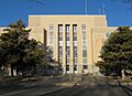
Quay County Courthouse in 2008
-

Tucumcari logo
-
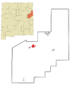
Location of Tucumcari in New Mexico
See also
 In Spanish: Tucumcari, Nuevo México para niños
