Quay County, New Mexico facts for kids
Quick facts for kids
Quay County
|
|
|---|---|

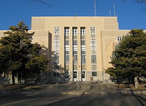
Quay County Courthouse in Tucumcari
|
|

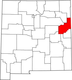
Location within the U.S. state of New Mexico
|
|
 New Mexico's location within the U.S. |
|
| Country | |
| State | |
| Founded | February 28, 1903 |
| Named for | Matthew Quay |
| Seat | Tucumcari |
| Largest city | Tucumcari |
| Area | |
| • Total | 2,882 sq mi (7,460 km2) |
| • Land | 2,874 sq mi (7,440 km2) |
| • Water | 7.2 sq mi (19 km2) 0.3%% |
| Population
(2020)
|
|
| • Total | 8,746 |
| • Density | 3.0347/sq mi (1.17170/km2) |
| Time zones | |
| Entire county (legally) | UTC−7 (Mountain) |
| • Summer (DST) | UTC−6 (MDT) |
| Nara Visa (unofficially) | UTC−6 (Central) |
| • Summer (DST) | UTC−5 (CDT) |
| Congressional district | 3rd |
Quay County (/ˈkweɪ/) is a county in the state of New Mexico. It was created on February 28, 1903. As of the 2020 U.S. census, about 8,746 people live there. The main town and county seat is Tucumcari.
The county was named after Matthew Quay, a Pennsylvania senator. He was a strong supporter of New Mexico becoming a state. Quay County's eastern side touches the Texas state line.
Contents
Geography of Quay County
Quay County is located in eastern New Mexico. It shares a border with Texas.
According to the U.S. Census Bureau, the county covers a total area of about 2,882 square miles. Most of this area, about 2,874 square miles, is land. Only a small part, about 7.2 square miles (0.3%), is water.
Neighboring Counties
Quay County is surrounded by several other counties. These are its neighbors:
- Union County (to the north)
- Harding County (to the northwest)
- San Miguel County (to the west)
- Guadalupe County (to the west)
- De Baca County (to the southwest)
- Roosevelt County (to the south)
- Curry County (to the south)
- Deaf Smith County, Texas (to the southeast)
- Oldham County, Texas (to the east)
- Hartley County, Texas (to the northeast)
Population and People
The number of people living in Quay County has changed over the years. Here's how the population has grown and shrunk:
| Historical population | |||
|---|---|---|---|
| Census | Pop. | %± | |
| 1910 | 14,912 | — | |
| 1920 | 10,444 | −30.0% | |
| 1930 | 10,828 | 3.7% | |
| 1940 | 12,111 | 11.8% | |
| 1950 | 13,971 | 15.4% | |
| 1960 | 12,279 | −12.1% | |
| 1970 | 10,903 | −11.2% | |
| 1980 | 10,577 | −3.0% | |
| 1990 | 10,823 | 2.3% | |
| 2000 | 10,155 | −6.2% | |
| 2010 | 9,041 | −11.0% | |
| 2020 | 8,746 | −3.3% | |
| U.S. Decennial Census 1790-1960 1900-1990 1990-2000 2010 |
|||
What the 2010 Census Showed
In 2010, there were 9,041 people living in Quay County. These people lived in 4,072 households. A household is a group of people living together. There were also 2,502 families.
The population density was about 3.1 people per square mile. This means the county is not very crowded. There were 5,569 housing units, which are places where people can live.
Most people in the county were white (86.1%). Other groups included American Indian (1.2%), Black or African American (1.1%), and Asian (1.0%). About 7.2% of people were from other races, and 3.4% were from two or more races. A large part of the population, 42.4%, identified as Hispanic or Latino.
The average age of people in Quay County was 45.6 years old. About 26.4% of households had children under 18 living with them.
Towns and Villages
Quay County has several communities where people live.
City
- Tucumcari (This is the main town and the county seat.)
Villages
Special Community
- Nara Visa (This is a "census-designated place," which means it's a community identified by the census bureau.)
Other Places to Live
- Bard
- Endee
- Forrest
- Glenrio (Part of this community is also in Texas.)
- McAlister
- Montoya
- Quay
- Wheatland
Schools in Quay County
Several school districts serve the students in Quay County:
- Grady Municipal Schools
- House Municipal Schools
- Logan Municipal Schools
- Melrose Public Schools
- San Jon Municipal Schools
- Tucumcari Public Schools
See also
 In Spanish: Condado de Quay para niños
 | John T. Biggers |
 | Thomas Blackshear |
 | Mark Bradford |
 | Beverly Buchanan |

