
Glenrio, New Mexico and Texas facts for kids
Quick facts for kids
Glenrio, New Mexico
Glenrio, Texas |
|
|---|---|

Closed café in Glenrio
|
|

Topographic map of Glenrio, 1982
|
|
| Country | United States |
| State | New Mexico Texas |
| Counties | Quay County, New Mexico Deaf Smith County, Texas |
| Elevation | 3,855 ft (1,175 m) |
| Population
(2010)
|
|
| • Total | 0 |
| ZIP Code |
88434
|
| GNIS feature ID | 915829 |
|
Glenrio Historic District
|
|

Glenrio Historic District
Location in New Mexico

Glenrio Historic District
Location in Texas

Glenrio Historic District
Location in the United States
|
|
| Location | Texas State Highway Loop 504 / New Mexico State Road 1578, Glenrio |
| Area | 31.7 acres (12.8 ha) |
| Built | 1926 |
| Architectural style | Bungalow/Craftsman, Moderne |
| MPS | Route 66 through New Mexico MPS, Route 66 in Texas MPS |
| NRHP reference No. | 06001258, 06001259 |
| Significant dates | |
| Added to NRHP | January 17, 2007 |
Glenrio, once known as Rock Island, is a small, quiet place that sits right on the border between Texas and New Mexico in the United States. It's known as a ghost town because most people have moved away. Glenrio was an important stop on the famous U.S. Route 66, a historic highway. Today, a special part of Glenrio, called the Glenrio Historic District, is recognized for its history and is listed on the National Register of Historic Places.
The community started in 1903 as a stop for the Rock Island Railroad. Its name comes from two words: "glen," which means a narrow valley, and "rio," which means river in Spanish.
Contents
History of Glenrio
Glenrio began as a railroad town. In 1908, the Rock Island and Pacific Railroad changed its name from Rock Island to Glenrio. By 1917, cars started arriving on the dusty Ozark Trail. The first buildings were made of adobe, a type of sun-dried brick. The Angel House, built around 1910, was located in New Mexico.
Glenrio on Route 66
On November 11, 1926, the Ozark Trail became part of the famous U.S. Route 66. By the 1930s, Route 66 was a paved road. Glenrio had several filling stations, a restaurant, and a motel to serve travelers. The road was made wider in the 1950s. A Texaco gas station (built in 1950) and a diner (the Brownlee Diner/Little Juarez Café, built in 1952) were built in Texas. They had a cool, modern design called art moderne.
Because Glenrio was right on the state line, businesses sometimes chose where to build based on state laws. For example, all the gasoline was sold in Texas because New Mexico had higher gas taxes. The State Line Bar and a motel from the 1930s were built in New Mexico. This was because Deaf Smith County, Texas, was a "dry county" at the time, meaning alcohol could not be sold there.
The railroad station was in Texas. The local post office, built around 1935, was in New Mexico. A water tank and windmill were also built in New Mexico around 1945.
Changes and Decline
The Joseph Brownlee House was moved to Glenrio from Amarillo in 1950. Glenrio was home to the "First Motel in Texas" or "Last Motel in Texas." This was Homer Ehresman's family-run State Line Café and Gas Station (1953) and the Texas Longhorn Motel (1955). These businesses served travelers on Route 66 for many years.
However, in September 1973, Interstate 40 was built and bypassed Glenrio. This meant cars no longer drove through the town. As a result, Glenrio began to decline in 1975, and many businesses closed. For example, the Texas Longhorn Motel closed in 1976. Three other gas stations (the 1925 Broyles Mobil, a 1935 Texaco, and the 1946 Ferguson) once operated in New Mexico.
The State Border Question
For many years, there was a disagreement about which state the eastern part of Glenrio belonged to. The border between Texas and New Mexico was supposed to be a straight line called the 103rd meridian. However, a survey done in 1859 mistakenly placed the border a few miles too far west. This made parts of Glenrio appear to be in Texas.
Even though New Mexico tried to claim the land, it has remained part of Texas. Today, the land and towns in this disputed strip are taxed and governed by the State of Texas.
Location of Glenrio
Glenrio is located just south of Interstate 40 at Texas exit 0. You can reach it by taking Business I-40. This road turns into a gravel road at the state line. This gravel road was once the original paved Route 66. Quay County removed the paving because it was too expensive to maintain. The town's mail used to be handled by a post office on the New Mexico side.
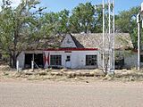
Today, Glenrio has the remains of the Texas Longhorn Motel and its café and Phillips 66 gas station. You can also see the old post office, the diner, and the Texaco service station. The old Route 66 roadbed and the former railroad tracks are also visible. The railroad tracks were removed in the 1980s. A few homes still stand in Glenrio, but most are empty.
Glenrio Historic District
The Glenrio Historic District is a special area of about 31.7 acres (12.8 hectares). It was added to the National Register of Historic Places in 2007. When it was listed, the district included 12 important buildings and four other important structures that show the town's history.
Glenrio Welcome Center
On June 25, 2008, the State of New Mexico opened the Glenrio Welcome Center. It is located on Interstate 40 right at the Texas state line. This center is a modern rest stop for travelers. It has a place for pets to walk, a livestock corral, and wireless Internet access. There's also a movie theater and information kiosks to help visitors. The center was built to welcome many visitors each year. It also uses green features, like recycling water for plants and a wind turbine to create some of its own energy.
Glenrio in Movies
Glenrio has appeared in movies!
- Parts of the movie The Grapes of Wrath (1940) were filmed here.
- In the animated film Cars (2006), the town of Radiator Springs has an abandoned "Glenn Rio Motel." The design of Glenrio's Little Juarez Café was used for a vacant building that later becomes the Racing Museum.
- The opening scene from the movie Daylight's End (2018) was also filmed in Glenrio.
Photo gallery
-
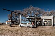
Closed café and gas station in Glenrio
-
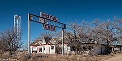
Closed hotel in Glenrio
-
First/Last Motel in Texas, Glenrio
.jpg)
.jpg)

