Harding County, New Mexico facts for kids
Quick facts for kids
Harding County
|
|
|---|---|

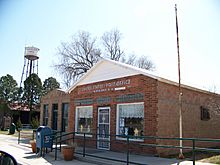
Mosquero post office
|
|

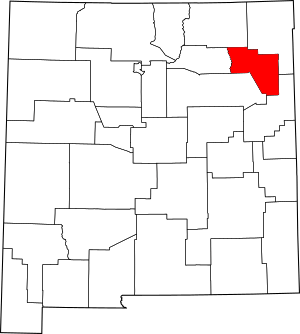
Location within the U.S. state of New Mexico
|
|
 New Mexico's location within the U.S. |
|
| Country | |
| State | |
| Founded | March 4, 1921 |
| Named for | Warren G. Harding |
| Seat | Mosquero |
| Largest village | Roy |
| Area | |
| • Total | 2,126 sq mi (5,510 km2) |
| • Land | 2,125 sq mi (5,500 km2) |
| • Water | 0.4 sq mi (1 km2) 0.02%% |
| Population
(2020)
|
|
| • Total | 657 |
| • Density | 0.30903/sq mi (0.11932/km2) |
| Time zone | UTC−7 (Mountain) |
| • Summer (DST) | UTC−6 (MDT) |
| Congressional district | 3rd |
Harding County is a county located in the state of New Mexico in the United States. In 2020, only 657 people lived there. This makes it the county with the fewest people in New Mexico. It is also one of the smallest counties by population in the entire U.S.
The main town, or county seat, is Mosquero. The county was named after United States President Warren G. Harding. It was created on March 4, 1921, the same day he became president. This makes him the most recent president to have a county named after him.
The only two official towns in Harding County are Roy and Mosquero.
Contents
Where is Harding County?
The U.S. Census Bureau says that Harding County covers about 2,126 square miles. Most of this area is land, with only a tiny bit being water.
The county has two main types of land. In the northwest, you'll find high, open prairie land with very few trees. This area is part of the High Plains. To the southeast, the land is lower and more like a semi-desert rangeland.
These two areas are separated by a steep rocky edge called the Canadian Escarpment. The Canadian River flows through a deep, narrow canyon and forms the western border of the county.
Neighboring Counties
Harding County shares borders with several other counties:
- Union County to the northeast
- Quay County to the southeast
- San Miguel County to the south
- Mora County to the west
- Colfax County to the northwest
Protected Lands
Part of the Kiowa National Grassland is located within Harding County. This is a protected area managed for conservation and public use.
How Many People Live Here?
| Historical population | |||
|---|---|---|---|
| Census | Pop. | %± | |
| 1930 | 4,421 | — | |
| 1940 | 4,374 | −1.1% | |
| 1950 | 3,013 | −31.1% | |
| 1960 | 1,874 | −37.8% | |
| 1970 | 1,348 | −28.1% | |
| 1980 | 1,090 | −19.1% | |
| 1990 | 987 | −9.4% | |
| 2000 | 810 | −17.9% | |
| 2010 | 695 | −14.2% | |
| 2020 | 657 | −5.5% | |
| U.S. Decennial Census 1790-1960 1900-1990 1990-2000 2010 |
|||
The number of people living in Harding County has changed a lot over the years. In 1930, over 4,400 people lived there. Since then, the population has slowly decreased. By 2020, only 657 people called Harding County home.
In 2010, there were 695 people living in the county. About 15% of homes had children under 18. The average age of people living in Harding County was about 56 years old.
Towns and Communities
Harding County has a few small towns and communities:
Villages
Unincorporated communities
See Also
 In Spanish: Condado de Harding (Nuevo México) para niños
 | Roy Wilkins |
 | John Lewis |
 | Linda Carol Brown |

