Mora County, New Mexico facts for kids
Quick facts for kids
Mora County
|
|
|---|---|

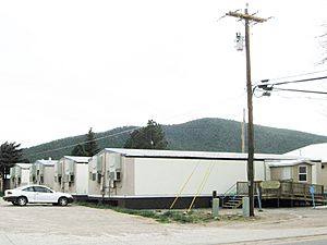
Mora County Courthouse in Mora
|
|

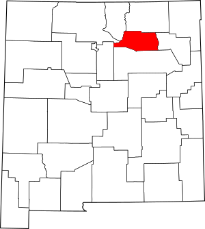
Location within the U.S. state of New Mexico
|
|
 New Mexico's location within the U.S. |
|
| Country | |
| State | |
| Founded | February 1, 1860 |
| Named for | Mora, New Mexico |
| Seat | Mora |
| Largest village | Mora |
| Area | |
| • Total | 1,934 sq mi (5,010 km2) |
| • Land | 1,931 sq mi (5,000 km2) |
| • Water | 2.3 sq mi (6 km2) 0.1%% |
| Population
(2020)
|
|
| • Total | 4,189 |
| • Density | 2.1660/sq mi (0.83629/km2) |
| Time zone | UTC−7 (Mountain) |
| • Summer (DST) | UTC−6 (MDT) |
| Congressional district | 3rd |
Mora County (in Spanish: Condado de Mora) is a county located in the state of New Mexico, USA. In 2020, about 4,189 people lived there. The main town and county seat is Mora.
Mora County also includes another special area called Watrous. There is also a village named Wagon Mound. Plus, there are 12 smaller communities that are not officially towns. Mora became a county on February 1, 1860.
Contents
History of Mora County
Before Spanish settlers arrived, the Mora area was home to Native American tribes. Groups like the Ute, Navajo, and Apache often used the Mora Valley. They were nomadic, meaning they moved from place to place.
Early Spanish Settlement
Spanish settlers began living in the Mora Valley in the late 1700s. This happened after Governor Juan Bautista de Anza made peace with the Comanches. This peace agreement opened up the eastern side of the Sangre de Cristo Mountains for people to settle.
The Mora Valley became a path for Spanish explorers. But people did not live there permanently until the early 1800s. The first written records of settlement show a church being built in 1818. This was three years before Mexico became independent from Spain.
Mexican Rule and Permanent Homes
The Mexican government officially started the Mora Land Grant in 1835. This led to many families settling in the county. These settlers came from places like Las Trampas and Picuris. Later, more families arrived from other parts of New Mexico.
Each family received a piece of land. This was part of a large land grant of over 800,000 acres. The grant was given by Governor Albino Pérez on September 28, 1835. Between 25 and 76 families moved to the Mora Valley because of this grant.
Changes During Wars
In 1836, the Republic of Texas broke away from Mexico. Texas claimed eastern New Mexico, including what is now Mora County. However, Texas did not actually control this area.
In 1843, a group from Texas raided the town of Mora. They claimed they were stopping cattle rustling. But they also tried to steal horses and take people.
The United States took over Texas in 1846. Then, US General Stephen W. Kearny took control of Santa Fe, New Mexico. This brought Mora County under American control. But many local people still felt they were part of Mexico.
Mexican-American War and US Control
The Mexican–American War started in 1846. During this war, the US military occupied much of New Mexico. This included Mora County.
During the Taos Revolt in 1847, local Mexican and Puebloan groups fought the US Army. They pushed back a small US force in the First Battle of Mora. But then, in the Second Battle of Mora, the US Army burned the village and farms. This ended the fighting in the area.
The war ended on February 3, 1848. Mora Valley and the rest of the region officially became part of the US. This was part of the Treaty of Guadalupe Hidalgo. New Mexico became a US territory on September 9, 1850.
Becoming Part of the United States
In 1851, the US Army built Fort Union in Mora Valley. This fort was built on private land without permission. This caused a long legal problem for the local landowners.
However, the fort also brought money to the area. Local farmers sold their goods to the soldiers. Several grist mills (places that grind grain) were built. One successful mill opened in 1855.
Mora officially became a US county on February 1, 1860. A church was built in the village of Chacon in 1864. This showed that more people were settling there.
New Mexico became the 47th US state on January 6, 1912. Even though many people in Mora County still spoke Spanish, the area continued to grow.
In 2013, Mora County made history. It became the first county in the US to ban oil and gas drilling on both public and private lands.
Today, the county seat, Mora, is made up of four nearby settlements and three plazas.
Geography
Mora County covers about 1,934 square miles. Only a very small part (0.1%) is covered by water. The highest point in the county is Truchas Peak. Its top is about 13,102 feet (3,993 meters) high.
Neighboring Counties
Mora County shares borders with several other counties:
- Colfax County – to the north
- Harding County – to the east
- San Miguel County – to the south
- Santa Fe County – to the west
- Rio Arriba County – to the west
- Taos County – to the northwest
Protected Natural Areas
Parts of these important natural areas are located in Mora County:
- Carson National Forest
- Fort Union National Monument
- Kiowa National Grassland
- Santa Fe National Forest
- Rio Mora National Wildlife Refuge
Population Information
| Historical population | |||
|---|---|---|---|
| Census | Pop. | %± | |
| 1860 | 5,566 | — | |
| 1870 | 8,056 | 44.7% | |
| 1880 | 9,751 | 21.0% | |
| 1890 | 10,618 | 8.9% | |
| 1900 | 10,304 | −3.0% | |
| 1910 | 12,611 | 22.4% | |
| 1920 | 13,915 | 10.3% | |
| 1930 | 10,322 | −25.8% | |
| 1940 | 10,981 | 6.4% | |
| 1950 | 8,720 | −20.6% | |
| 1960 | 6,028 | −30.9% | |
| 1970 | 4,673 | −22.5% | |
| 1980 | 4,205 | −10.0% | |
| 1990 | 4,264 | 1.4% | |
| 2000 | 5,180 | 21.5% | |
| 2010 | 4,881 | −5.8% | |
| 2020 | 4,189 | −14.2% | |
| US Decennial Census 1790–1960 1900–1990 1990–2000 2010 |
|||
In 2010, there were 4,881 people living in Mora County. There were 2,114 households, which are groups of people living together. The population density was about 2.5 people per square mile.
Most of the people in the county were white (70.9%). About 81.0% of the population were of Hispanic or Latino background.
The average age of people in Mora County was 46 years old. About 26.4% of households had children under 18 living with them. The average household had 2.31 people.
The average income for a household was $37,784. For families, it was $42,122. About 11.9% of the people in the county had lower incomes.
Places to Visit
Communities
Village
Census-Designated Places
Unincorporated Communities
- Buena Vista
- Canoncito
- Chacon
- Cleveland
- Golondrinas
- Guadalupita
- Holman
- La Cueva
- Ledoux, Mora County, New Mexico
- Ocate
- Ojo Feliz
- Rainsville
Former Community
- Valmora (now a private retreat center)
Education
Students in Mora County attend schools in these districts:
- Las Vegas City Public Schools
- Mora Independent Schools
- Wagon Mound Public Schools
See also
 In Spanish: Condado de Mora para niños
 | Delilah Pierce |
 | Gordon Parks |
 | Augusta Savage |
 | Charles Ethan Porter |

