Rio Arriba County, New Mexico facts for kids
Quick facts for kids
Rio Arriba County
|
||
|---|---|---|
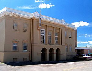
Rio Arriba County Courthouse, Isaac Rapp, architect, 1916-17
|
||
|
||
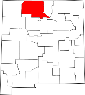
Location within the U.S. state of New Mexico
|
||
 New Mexico's location within the U.S. |
||
| Country | ||
| State | ||
| Founded | 1852 | |
| Named for | location on the upper Rio Grande (río arriba means "upriver" in Spanish) | |
| Seat | Tierra Amarilla | |
| Largest city | Española | |
| Area | ||
| • Total | 5,896 sq mi (15,270 km2) | |
| • Land | 5,861 sq mi (15,180 km2) | |
| • Water | 35 sq mi (90 km2) 0.6%% | |
| Population
(2020)
|
||
| • Total | 40,363 | |
| • Density | 6.8458/sq mi (2.64319/km2) | |
| Time zone | UTC−7 (Mountain) | |
| • Summer (DST) | UTC−6 (MDT) | |
| Congressional district | 3rd | |
Rio Arriba County (Spanish: Condado de Río Arriba) is a county located in the northern part of New Mexico, a state in the United States. The name Río Arriba means "upriver" in Spanish, which makes sense because the county is located along the upper part of the Rio Grande river.
As of the 2020 census, about 40,363 people live here. The main town and county seat is Tierra Amarilla. The county's northern edge touches the state of Colorado. Rio Arriba County is also part of a larger area that includes cities like Española, Albuquerque, and Santa Fe.
Contents
History of Rio Arriba County
Rio Arriba County was one of the first nine counties created in the Territory of New Mexico way back in 1852. When it was first formed, it was much larger. It even stretched all the way west to where Las Vegas, Nevada is today!
Over the years, the county seat, which is the main town where the county government is located, moved a few times:
- It started in San Pedro de Chamita.
- Then it moved to Los Luceros.
- In 1860, it moved to Plaza del Alcalde.
- Since 1880, Tierra Amarilla has been the county seat.
A battle called the Battle of Embudo Pass happened in the southern part of the county in January 1847. This was during the Mexican-American War.
Geography of Rio Arriba County
Rio Arriba County is quite large! It covers a total area of about 5,896 square miles. Most of this (5,861 square miles) is land, and a small part (35 square miles) is water. It is the fifth-largest county in New Mexico by land area.
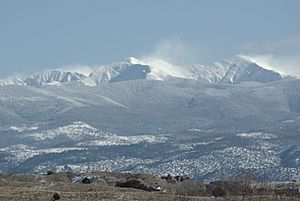
The county's size changed over time, especially after San Juan County was created. The highest point in the county is the top of Truchas Peak, which stands at 13,102 feet tall.
Neighboring Counties
Rio Arriba County shares its borders with several other counties:
- Taos County - to the east
- Mora County - to the southeast
- Santa Fe County - to the south
- Los Alamos County - to the south
- Sandoval County - to the south
- San Juan County - to the west
- Archuleta County, Colorado - to the north (in Colorado)
- Conejos County, Colorado - to the north (in Colorado)
Protected Natural Areas
Parts of these important natural areas are found within Rio Arriba County:
- Carson National Forest
- El Camino Real de Tierra Adentro National Historic Trail
- Santa Fe National Forest
- Valles Caldera National Preserve
Population and People
The population of Rio Arriba County has changed a lot over the years. Here's a look at how many people have lived there during different census years:
| Historical population | |||
|---|---|---|---|
| Census | Pop. | %± | |
| 1850 | 10,668 | — | |
| 1860 | 9,849 | −7.7% | |
| 1870 | 9,294 | −5.6% | |
| 1880 | 11,023 | 18.6% | |
| 1890 | 11,534 | 4.6% | |
| 1900 | 13,777 | 19.4% | |
| 1910 | 16,624 | 20.7% | |
| 1920 | 19,552 | 17.6% | |
| 1930 | 21,381 | 9.4% | |
| 1940 | 25,352 | 18.6% | |
| 1950 | 24,997 | −1.4% | |
| 1960 | 24,193 | −3.2% | |
| 1970 | 25,170 | 4.0% | |
| 1980 | 29,282 | 16.3% | |
| 1990 | 34,365 | 17.4% | |
| 2000 | 41,190 | 19.9% | |
| 2010 | 40,246 | −2.3% | |
| 2020 | 40,363 | 0.3% | |
| U.S. Decennial Census 1790-1960 1900-1990 1990-2000 2010 |
|||
What the 2010 Census Showed
In 2010, there were 40,246 people living in Rio Arriba County. About 71.3% of the people living in the county were of Hispanic or Latino origin. The largest ancestry groups included Mexican, Spanish, German, English, and Irish.
The average household had about 2.53 people, and the average family had about 3.09 people. The median age of people in the county was 39 years old.
Education in Rio Arriba County
Rio Arriba County has several public school districts that serve its students:
- Chama Valley Independent Schools
- Dulce Independent Schools
- Española Public Schools (this is the largest one)
- Jemez Mountain Public Schools
- Mesa Vista Consolidated Schools
- Peñasco Independent Schools
There is also a special school called Kha'p'o Community School in Santa Clara Pueblo. This school is connected to the Bureau of Indian Education (BIE).
Colleges and Universities
For students who want to continue their education after high school, Rio Arriba County has:
- Northern New Mexico College with campuses in Española and El Rito.
- A campus of New Mexico Highlands University in Española.
Fun Places to Visit
Rio Arriba County has many interesting places to explore:
- Abiquiu Lake - a beautiful lake for recreation.
- Chama River (Rio Grande) - a scenic river.
- Cumbres & Toltec Scenic Railroad - a historic train ride.
- Echo Amphitheater - a natural rock formation with amazing echoes.
- Jicarilla Apache Reservation - the home of the Jicarilla Apache Nation.
- Puye Cliff Dwellings - ancient homes built into cliffs.
- Ghost Ranch - a famous retreat and education center.
- Monastery of Christ in the Desert & Abbey Brewing Company - a peaceful monastery.
- Project Gasbuggy - a historic site related to a past energy experiment.
- Tierra Amarilla (the county seat) & Brazos Cliffs - the county's main town and nearby stunning cliffs.
Communities in Rio Arriba County
Cities
Villages
Census-Designated Places (CDPs)
These are areas identified by the Census Bureau for statistical purposes.
- Abiquiú
- Alcalde
- Brazos
- Canjilon
- Cañones
- Canova
- Chamita
- Chili
- Chimayo (part)
- Cordova
- Coyote
- Dixon
- Dulce
- El Duende
- El Rito
- Ensenada
- Gallina
- Hernandez
- La Madera
- La Mesilla
- La Villita
- Lindrith
- Los Luceros
- Los Ojos
- Lumberton
- Lybrook
- Lyden
- Medanales
- Ohkay Owingeh
- Ojo Caliente (part)
- Ojo Sarco
- Pueblito
- Rio Chiquito (part)
- San Jose
- San Juan (former)
- Santa Clara Pueblo
- Tierra Amarilla (county seat)
- Truchas
- Velarde
- Youngsville
Other Communities
These are smaller, unincorporated communities.
Ghost Towns
These are towns that used to exist but are now abandoned.
- Hopewell
- Riverside
- Santa Rosa de Lima
- Sublette
See also
 In Spanish: Condado de Río Arriba para niños
 | Audre Lorde |
 | John Berry Meachum |
 | Ferdinand Lee Barnett |


