Los Alamos County, New Mexico facts for kids
Quick facts for kids
Los Alamos County
|
|||
|---|---|---|---|

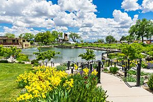
Ashley Pond Park in Los Alamos, New Mexico
|
|||
|
|||

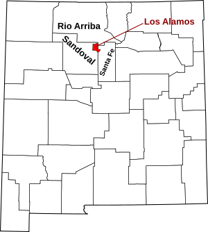
Location within the U.S. state of New Mexico
|
|||
 New Mexico's location within the U.S. |
|||
| Country | |||
| State | |||
| Founded | 1949 | ||
| Seat | Los Alamos | ||
| Largest community | Los Alamos | ||
| Area | |||
| • Land | 109 sq mi (280 km2) | ||
| • Water | 0.09 sq mi (0.2 km2) 0.08%% | ||
| Population
(2020)
|
|||
| • Total | 19,419 | ||
| • Density | 178/sq mi (69/km2) | ||
| Time zone | UTC−7 (Mountain) | ||
| • Summer (DST) | UTC−6 (MDT) | ||
| Congressional district | 3rd | ||
Los Alamos County is a special place in the state of New Mexico, USA. Its name means "The Poplars" or "Cottonwoods" in Spanish. In 2020, about 19,419 people lived here. It's the smallest county in New Mexico by size.
Long ago, the U.S. federal government managed Los Alamos County all by itself. This was during the Manhattan Project, a secret project in World War II. Today, Los Alamos County is like any other county in New Mexico. It has two main communities: Los Alamos and White Rock.
Los Alamos County is also home to the famous Los Alamos National Laboratory. This county is known for having the lowest level of child poverty in the entire United States. This means very few children here live in families with low incomes.
Contents
Geography of Los Alamos County
Los Alamos County covers about 109 square miles. Almost all of this area is land, with very little water. It is the smallest county in New Mexico. There are no large lakes or rivers within the county. The highest point in the county is near Caballo Mountain, which is about 10,480 feet (3,194 meters) above sea level.
Neighboring Areas
Los Alamos County shares its borders with other counties and Native American lands.
- Rio Arriba County is to the north, northwest, and northeast.
- Santa Fe County is to the east.
- Sandoval County is to the south and southwest.
Nearby Native American Pueblos
- Santa Clara Pueblo is to the northeast.
- San Ildefonso Pueblo is to the east.
Protected Natural Places
Parts of two important protected areas are found in Los Alamos County:
- Bandelier National Monument: This area protects ancient cliff dwellings and beautiful landscapes.
- Santa Fe National Forest: This forest offers outdoor activities and protects natural habitats.
People of Los Alamos County
The number of people living in Los Alamos County has changed over the years.
| Historical population | |||
|---|---|---|---|
| Census | Pop. | %± | |
| 1950 | 10,476 | — | |
| 1960 | 13,037 | 24.4% | |
| 1970 | 15,198 | 16.6% | |
| 1980 | 17,599 | 15.8% | |
| 1990 | 18,115 | 2.9% | |
| 2000 | 18,343 | 1.3% | |
| 2010 | 17,950 | −2.1% | |
| 2020 | 19,419 | 8.2% | |
| U.S. Decennial Census 1790–1960 1900–1990 1990–2000 2010 |
|||
Population in 2010
In 2010, there were 17,950 people living in Los Alamos County. Most people were white (87.8%). About 14.7% of the population was of Hispanic or Latino origin. The average age of people in the county was 44.3 years old.
Quality of Life in Los Alamos
Los Alamos County is known for its high quality of life. In 2004, a study called it the best place to live in the United States. This is because many residents work as scientists and engineers at the Los Alamos National Laboratory. They often have stable jobs and good incomes.
The county has many people with advanced degrees, like PhDs. In 2011, the average household income was very high. Los Alamos County also has one of the lowest levels of poverty in the U.S. This includes the lowest level of child poverty. Other good things about living here are affordable homes and short travel times to work.
In 2021, U.S. News & World Report said Los Alamos County was the healthiest county in the U.S. People living here tend to live longer, about 83.4 years on average. This is much higher than the U.S. average of 77.5 years.
Communities in Los Alamos County
Los Alamos County has two main communities:
- Los Alamos (This is the county seat, where the main government offices are)
- White Rock
Education in Los Alamos County
All schools in Los Alamos County are part of the Los Alamos Public Schools system. Los Alamos High School is the main high school for students in the area.
Energy Resources
Los Alamos County and the Los Alamos National Laboratory have shared energy resources since 1985. They get power from different sources.
Current Energy Sources
Here's a look at where Los Alamos County gets its energy:
| Resource | Type | Amount (MW) |
|---|---|---|
| Power Purchase Agreement | Mixed | 45 |
| LANL Combustion Turbine | Gas | 25 |
| Abiquiu Hydroelectric | Hydro | 17 |
| Laramie River Station | Coal | 10 |
| Western Area Power Adm. | Hydro | 10 |
| El Vado Hydroelectric | Hydro | 9 |
| East Jemez Photovoltaic | Solar | 1 |
| Purchased Power Contracts | Variable | N/A |
| Transmission Arrangements | Variable | N/A |
Future Energy Plans
Both Los Alamos County and the Los Alamos National Laboratory are working to reduce their carbon emissions. This helps fight climate change. In 2015, Los Alamos County joined a project to use small nuclear reactors for energy. This project was called the Carbon Free Power Project. It aimed to provide clean energy to many areas in the United States. However, the project was stopped in 2023 because costs went up.
Los Alamos has a history with nuclear energy. Nuclear energy can be a clean source of power, similar to renewable energy sources like solar or wind, because it produces very little greenhouse gas.
See also
 In Spanish: Condado de Los Álamos para niños
 | Bayard Rustin |
 | Jeannette Carter |
 | Jeremiah A. Brown |


