Sandoval County, New Mexico facts for kids
Quick facts for kids
Sandoval County
|
||
|---|---|---|

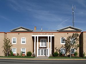
Sandoval County Courthouse in Bernalillo
|
||
|
||

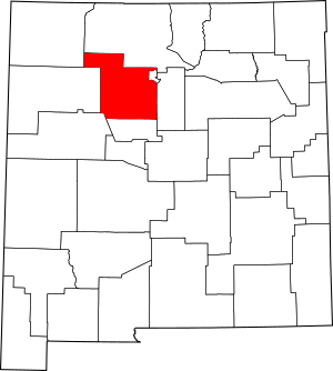
Location within the U.S. state of New Mexico
|
||
 New Mexico's location within the U.S. |
||
| Country | ||
| State | ||
| Founded | 1903 | |
| Named for | Sandoval family | |
| Seat | Bernalillo | |
| Largest city | Rio Rancho | |
| Area | ||
| • Total | 3,716 sq mi (9,620 km2) | |
| • Land | 3,711 sq mi (9,610 km2) | |
| • Water | 5.3 sq mi (14 km2) 0.1%% | |
| Population
(2020)
|
||
| • Total | 148,834 | |
| • Density | 35/sq mi (14/km2) | |
| Time zone | UTC−7 (Mountain) | |
| • Summer (DST) | UTC−6 (MDT) | |
| Congressional districts | 1st, 3rd | |
Sandoval County is a place in the U.S. state of New Mexico. In 2020, about 148,834 people lived there. This makes it the fourth-biggest county in New Mexico by population. The main town, or county seat, is Bernalillo. Sandoval County is also part of the larger Albuquerque metropolitan area.
Contents
History of Sandoval County
Sandoval County was created in 1903. It was formed from the northern part of Bernalillo County. The county got its name from a well-known Spanish family who owned a lot of land in the area.
The first county seat was Corrales. However, it was moved to Bernalillo in 1905. The Mormon Battalion Monument (New Mexico) is also located in Sandoval County.
Geography and Natural Features
According to the U.S. Census Bureau, Sandoval County covers about 3,716 square miles. Most of this area, about 3,711 square miles, is land. Only a small part, about 5.3 square miles, is water.
The highest point in the county is the top of Redondo Peak. This peak stands at 11,254 feet high.
A small part of Sandoval County is separate from the main area. It is located between Los Alamos County and Santa Fe County. This happened when Los Alamos County was created. This land was important to local Native American groups, so it stayed part of Sandoval County.
Neighboring Counties
Sandoval County shares its borders with several other counties:
- Rio Arriba County to the north
- Los Alamos County to the northeast (west of the separate part)
- Santa Fe County to the east (in two places, including the separate part)
- Bernalillo County to the south
- Cibola County to the southwest
- McKinley County to the west
- San Juan County to the northwest
Native American Reservations in Sandoval County
Sandoval County is home to many Indian reservations. It has 12 reservations and two areas used by different groups. This is one of the highest numbers of reservations in any county in the United States.
Here are some of the reservations and joint-use areas:
- Cochiti Pueblo (partly in Santa Fe County)
- Jemez Pueblo
- Jicarilla Apache Indian Reservation (partly in Rio Arriba County)
- Laguna Pueblo (partly in Bernalillo, Cibola, and Valencia Counties)
- Navajo Nation (a very large area extending into other states)
- San Felipe Pueblo
- San Felipe/Santa Ana joint use area
- San Felipe/Santo Domingo joint use area
- San Ildefonso Pueblo (partly in Santa Fe County)
- Sandia Pueblo (partly in Bernalillo County)
- Santa Ana Pueblo
- Santa Clara Pueblo (partly in Rio Arriba and Santa Fe counties)
- Santo Domingo Pueblo (partly in Santa Fe County)
- Zia Pueblo
National Protected Areas
Parts of several important national protected areas are found in Sandoval County. These areas help protect nature and history.
- Bandelier National Monument
- Cibola National Forest
- El Camino Real de Tierra Adentro National Historic Trail
- Kasha-Katuwe Tent Rocks National Monument
- Santa Fe National Forest
- Valles Caldera National Preserve
Population and People
| Historical population | |||
|---|---|---|---|
| Census | Pop. | %± | |
| 1910 | 8,579 | — | |
| 1920 | 8,863 | 3.3% | |
| 1930 | 11,144 | 25.7% | |
| 1940 | 13,898 | 24.7% | |
| 1950 | 12,438 | −10.5% | |
| 1960 | 14,201 | 14.2% | |
| 1970 | 17,492 | 23.2% | |
| 1980 | 34,799 | 98.9% | |
| 1990 | 63,319 | 82.0% | |
| 2000 | 89,908 | 42.0% | |
| 2010 | 131,561 | 46.3% | |
| 2020 | 148,834 | 13.1% | |
| U.S. Decennial Census 1790–1960 1900–1990 1990–2000 2010–2016 |
|||
In 2010, about 131,561 people lived in Sandoval County. There were 47,602 homes. The county had a population density of about 35.5 people per square mile.
Many different groups of people live in Sandoval County. About 35.1% of the people were of Hispanic or Latino background. The median age in the county was 37.9 years old.
Communities in Sandoval County
Sandoval County has several different types of communities.
Cities
Towns
- Bernalillo (This is the county seat, the main town for county government)
- Edgewood (part)
Villages
- Corrales
- Cuba
- Jemez Springs
- San Ysidro
Census-Designated Places (CDPs)
- Algodones
- Cañon
- Cochiti
- Cochiti Lake
- Jemez Pueblo
- La Cueva
- La Jara
- La Madera
- Peña Blanca
- Placitas
- Ponderosa
- Pueblo of Sandia Village
- Regina
- Rio Rancho Estates
- San Felipe Pueblo
- San Luis
- Santa Ana Pueblo
- Santo Domingo Pueblo
- Torreon
- Zia Pueblo
Unincorporated Community
Education in Sandoval County
Several school districts serve the students in Sandoval County:
- Albuquerque Public Schools
- Bernalillo Public Schools
- Cuba Independent Schools
- Jemez Valley Public Schools
- Los Alamos Public Schools
- Rio Rancho Public Schools
The Bureau of Indian Education (BIE) also runs schools in the county:
- Jemez Day School
- San Felipe Pueblo Elementary School
- T'siya (Zia) Day School
See also
 In Spanish: Condado de Sandoval para niños
 | Precious Adams |
 | Lauren Anderson |
 | Janet Collins |


