Navajo Nation facts for kids
Quick facts for kids
Navajo Nation
Naabeehó Bináhásdzo (Navajo)
|
|||
|---|---|---|---|
|
|||
| Anthem: ("Dah Naatʼaʼí Sǫʼ bił Sinil" and "Shí naashá" used for some occasions) |
|||
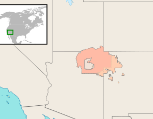
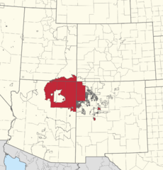
Location of the Navajo Nation.
Checkerboard-area in lighter shade (see text) |
|||
| Established | June 1, 1868 (Treaty) | ||
| Expansions | 1878–2016 | ||
| Chapter system | 1922 | ||
| Tribal Council | 1923 | ||
| Capital | Window Rock (Tségháhoodzání) |
||
| Subdivisions |
5 Agencies
|
||
| Government | |||
| • Body | Navajo Nation Council | ||
| Area | |||
| • Total | 27,413 sq mi (71,000 km2) | ||
| Population
(2020)
|
|||
| • Total | 165,158 | ||
| • Density | 6.02481/sq mi (2.326/km2) | ||
| 160,552 Native American 4,606 White |
|||
| Time zone | MST/MDT | ||
| Website | www.navajo-nsn.gov | ||
The Navajo Nation (Navajo: Naabeehó Bináhásdzo), also known as Navajoland, is a large Indian reservation in the United States. It is the home of the Navajo people, who call themselves Diné (meaning "the People"). This special area covers parts of northeastern Arizona, northwestern New Mexico, and southeastern Utah. The main government office is in Window Rock, Arizona.
The Navajo Nation is the biggest reservation in the United States. It is larger than ten U.S. states! It is also one of the few reservations that still includes the traditional lands of its people. In 2020, about 165,000 Navajo people lived on the reservation. Many more Navajo live in other parts of the U.S.
The U.S. gained this land in 1848 after the Mexican-American War. The reservation was first set up in 1868 in the New Mexico Territory. It has grown bigger several times since then. Its current borders were set in 1934.
Contents
In English, the official name for this area was first "Navajo Indian Reservation." This name was part of the 1868 Treaty of Bosque Redondo. On April 15, 1969, the tribe officially changed its name to the "Navajo Nation." You can see this name on their official seal.
In 1994, the Navajo Tribal Council decided not to change the name from "Navajo" to "Diné." Some people felt that "Diné" reminded them of a difficult time for the people. They thought "Navajo" was a better name for the future. In the Navajo language, Diné means "the People." Both "Navajo" and "Diné" are used by the Navajo people today. In 2017, the Navajo Nation Council again voted against changing the name to "Diné Nation." They worried it might confuse people.
In the Navajo language, the official area with its borders is called Naabeehó Bináhásdzo. This is different from Diné Bikéyah or Naabeehó Bikéyah, which mean the general idea of "Navajoland." These terms are also different from Dinétah. Dinétah is the name for the Navajo people's ancient homeland. It is located near four sacred Navajo mountains: Dookʼoʼoosłííd (San Francisco Peaks), Dibé Ntsaa (Hesperus Mountain), Sisnaajiní (Blanca Peak), and Tsoodził (Mount Taylor).
The Navajo people have a long history of how they govern themselves. This history is based on their clans and oral traditions. The clan system is very important to Navajo society. It includes rules for how people should behave. This way of life is called "walking in beauty." This system was in place long before Spanish people came to Dinétah.
On July 25, 1868, the U.S. Congress approved the Navajo Treaty. This treaty was signed by Navajo leaders like Barboncito and Armijo at Bosque Redondo, New Mexico. Since signing this treaty, the Navajo people have continued to change how their government works. They have blended their traditions with ideas from the "western world."
The Reservation's Start and Growth
In the mid-1800s, especially in the 1860s, many Navajo people were forced to leave their homes. The U.S. Army carried out military actions that destroyed homes and farms. They also took or killed livestock. This was done to weaken the Navajo and make them surrender. In 1864, about 8,000 Navajo adults and children were forced to march 300 miles. This difficult journey is known as the Long Walk of the Navajo. They were imprisoned at Bosque Redondo.
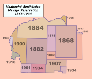
The Treaty of 1868 created the "Navajo Indian Reservation." After the treaty, the Navajo people left Bosque Redondo and returned to this new territory. The first reservation land was about 3.3 million acres. This original land is shown as a dark-brown rectangle on the Navajo Nation's flag.
Many Navajo people did not follow these new borders. They returned to where they had lived before the U.S. occupation. Some Navajo had never been to Hwéeldi (near Fort Sumner). They stayed near the Little Colorado and Colorado rivers, or on Naatsisʼáán (Navajo Mountain). Some even lived with Apache groups.
The reservation began to grow on October 28, 1878. President Rutherford Hayes signed an order that moved the western border 20 miles further west. More land was added throughout the late 1800s and early 1900s. Most of these additions happened through executive orders from U.S. presidents. For example, President Theodore Roosevelt added the area around Aneth, Utah in 1905. This was later confirmed by Congress in 1933.
The eastern border was shaped by a program called the Dawes Act of 1887. This act aimed to help Native Americans fit into American culture. It tried to divide tribal lands into smaller plots for individual Navajo families to farm. The land given to these families was not first considered part of the reservation. Any "leftover" land was sold to non-Native Americans. This program continued until 1934. Today, this mix of reservation and non-reservation land is called the "checkerboard area." It caused the Navajo people to lose much of their land.
In the southeastern part of the reservation, the Navajo Nation has bought some ranches. They call these lands Nahata Dził, or New Lands. These lands are leased to Navajo individuals, livestock companies, and grazing groups.
In 1996, a lawsuit called Cobell v. Salazar was filed. It was about money owed to Native Americans for their land. In 2009, the lawsuit was settled. It included a fund to buy back land interests and return land to tribal reservations. Through this program, individual Navajo members have received money for their land interests. Over 155,000 acres have been returned to the Navajo Nation.
In traditional Navajo culture, local leaders were chosen based on clans. Clans are family groups where children belong to their mother's family. A child's social standing comes from their mother and her clan. The mother's oldest brother often had a strong role in raising the children.
These clan leaders acted as a local government for the Navajo Nation.
Modern Government and Self-Determination
In 1933, during the Great Depression, the U.S. government tried to reduce the number of livestock on reservations. This was to help the environment because of too much grazing. The Navajo people strongly disagreed because they felt they were not asked enough about these changes. Livestock were very important to Navajo culture and showed a family's wealth.
At this time, the Indian Reorganization Act (IRA) of 1934 encouraged tribes to create governments like the U.S. government. Because of the anger about the livestock issues, Navajo voters did not trust the first proposed constitution. They worried it would stop them from developing their livestock. Later, in 1953, they worried about limits on using their mineral resources.
The Navajo people continued to use their traditional government based on clans. They chose headmen from their clan groups. They wanted to make sure they had control over their own future.
See also
 In Spanish: Nación Navajo para niños
 | William Lucy |
 | Charles Hayes |
 | Cleveland Robinson |


