
Mount Taylor (New Mexico) facts for kids
Quick facts for kids Mount Taylor |
|
|---|---|
| Tsoodził | |
 |
|
| Highest point | |
| Elevation | 11,305 ft (3,446 m) NAVD 88 |
| Prominence | 4,094 ft (1,248 m) |
| Geography | |

Mount Taylor
Location in New Mexico
|
|
| Location | Cibola County, New Mexico, U.S. |
| Parent range | San Mateo Mountains |
| Topo map | USGS Mount Taylor |
| Geology | |
| Mountain type | Stratovolcano |
| Climbing | |
| Easiest route | Hike |


Mount Taylor is a large, inactive volcano in northwest New Mexico. Its Navajo name is Navajo: Tsoodził, which means "The Great Mountain." It stands northeast of the town of Grants.
Mount Taylor is the highest point in the San Mateo Mountains. It is also the tallest peak in the Cibola National Forest.
The mountain was named in 1849 after Zachary Taylor, who was the U.S. President at the time. Before that, the Spanish called it Cebolleta, meaning "tender onion." This name is still used for a large flat-topped mountain (mesa) in the northern San Mateo Mountains. The Navajo, who consider the mountain sacred, still call it Turquoise Mountain (Tsoodził).
Mount Taylor is mostly covered with forests and some open grassy areas (meadows). It rises high above the desert below. The eastern side of the mountain has been heavily shaped by erosion, meaning wind and water have worn it away over time. The trees on its slopes were an important source of wood for nearby pueblos, which are Native American communities.
Contents
Mount Taylor's Volcanic Area
Mount Taylor is a big volcano that is part of a larger area of volcanoes. This area stretches to the northeast. It includes Mesa Chivato to the northeast and Grants Ridge to the southwest.
Most of the rocks in this volcanic area are made of a type of lava called trachybasalt. This lava has low amounts of silica, a common mineral. Other types of lava, like basalt, are also found but in smaller amounts.
This volcanic area sits where the Colorado Plateau and the Rio Grande rift meet. These are two large geological areas where the Earth's crust is pulling apart. The biggest volcanic "plug" in this area is Cabezon Peak. A volcanic plug is what's left when a volcano erodes away, leaving only the hardened lava that filled its vent. Cabezon Peak rises almost 2,000 feet above the flat land around it.
Native American Traditions


Mount Taylor is a very important and sacred place for many Native American groups. These include the pueblos of Acoma, Laguna, and Zuni. It is also sacred to the Hopi and Navajo people.
For the Navajo, Mount Taylor is Tsoodził, the blue bead mountain. It is sometimes called Turquoise Mountain. It is one of four sacred mountains that mark the main directions and the borders of the Dinetah. The Dinetah is the traditional homeland of the Navajo people. Mount Taylor marks the southern border. It is linked to the direction south and the color blue, and is seen as female.
In Navajo stories, First Man created the sacred mountains. He used soil from the Fourth World and special sacred materials. He made them to be like mountains from that world. He fastened Mount Taylor to the Earth with a stone knife. It is believed that special beings like Black God, Turquoise Boy, and Turquoise Girl live on the mountain.
According to a book called The Place Names of New Mexico, the Navajo believe Cabezon Peak is the head of a giant. This giant was killed by the Twin War Gods. The lava flow south of Grants is thought to be the giant's hardened blood.
Mountain Shape and Features
The eastern side of Mount Taylor has been heavily worn away by erosion. This has created a large, bowl-shaped area called an amphitheater. This area is about 5 square miles in size.
Scientists have different ideas about how tall the mountain once was. Some think it might have been as high as 14,000 feet (4,270 meters). However, it is more likely that the volcano was never taller than about 12,500 feet (3,800 meters).
The mountain is surrounded by a lot of volcanic rock pieces. But this debris and the natural amphitheater are due to erosion. They were not caused by a huge explosion like those at Mount St. Helens or Valles Caldera. The erosion has been so strong that it has even uncovered older Cretaceous sedimentary rocks. These rocks are found deep inside the volcano's core.
How Mount Taylor Formed
The Mount Taylor Volcanic Field is made of layers of volcanic rock. These layers formed during the late Cenozoic Era, which began about 66 million years ago. These volcanic rocks sit on top of older sedimentary rocks from the Cretaceous period.
This volcanic field is part of the Jemez Lineament. This is a long line of cracks in the Earth's crust. It is linked to younger volcanoes, less than 5 million years old. This is because of an old seam in the deep Proterozoic basement rock.
The way the volcanic layers are stacked shows a pattern. The earliest lava was more "intermediate" (like rhyolite). Over time, the lava became more "mafic" (like basalt). This change in magma type is thought to have happened because Mount Taylor had several small, short-lived magma chambers. It was not just one large, long-lasting chamber.
Volcanic Activity
Mount Taylor was an active volcano during the Pliocene and Pleistocene epochs. These periods were between about 5.3 million and 11,700 years ago. It is surrounded by many smaller, inactive volcanoes.
Scientists used a method called Potassium-argon (K-Ar) dating. This showed that most of Mount Taylor's volcanic activity happened between 4.3 and 1.5 million years ago. The busiest time for eruptions was between 3.0 and 2.5 million years ago. Mount Taylor was the main source of volcanic activity in this area during that time.
The eruptions of Mount Taylor happened in four main stages:
- First Stage: From 3.74 to 2.93 million years ago. This stage mostly produced basanite and alkali basalt lavas. These lavas formed flat-topped mountains called mesa caps. There were also smaller amounts of more silica-rich lavas, forming domes and plugs.
- Second Stage: From 2.88 to 2.78 million years ago. This stage built up much of the main volcano. It produced lavas like trachyandesite and trachydacite.
- Third Stage: From 2.75 to 2.52 million years ago. This stage finished building the volcano. It formed the lava flows at its peak. These were mostly trachyandesite and trachydacite.
- Fourth Stage: This final stage involved eruptions from the sides of the volcano. These were mostly trachybasalt lavas.
The lava from Mount Taylor is special because it is "alkaline." This type of lava is usually found in places where continents are pulling apart or on ocean islands, like Hawaii. It is not common in North America.
Climate
| Climate data for Mount Taylor 35.2398 N, 107.6112 W, Elevation: 10,876 ft (3,315 m) (1991–2020 normals) | |||||||||||||
|---|---|---|---|---|---|---|---|---|---|---|---|---|---|
| Month | Jan | Feb | Mar | Apr | May | Jun | Jul | Aug | Sep | Oct | Nov | Dec | Year |
| Mean daily maximum °F (°C) | 35.4 (1.9) |
36.1 (2.3) |
41.3 (5.2) |
47.7 (8.7) |
56.8 (13.8) |
68.2 (20.1) |
69.5 (20.8) |
67.0 (19.4) |
61.9 (16.6) |
53.1 (11.7) |
43.1 (6.2) |
35.6 (2.0) |
51.3 (10.7) |
| Daily mean °F (°C) | 24.9 (−3.9) |
25.3 (−3.7) |
29.8 (−1.2) |
34.3 (1.3) |
43.1 (6.2) |
53.5 (11.9) |
56.2 (13.4) |
54.4 (12.4) |
49.2 (9.6) |
40.3 (4.6) |
32.4 (0.2) |
25.4 (−3.7) |
39.1 (3.9) |
| Mean daily minimum °F (°C) | 14.4 (−9.8) |
14.5 (−9.7) |
18.4 (−7.6) |
20.9 (−6.2) |
29.4 (−1.4) |
38.7 (3.7) |
42.8 (6.0) |
41.8 (5.4) |
36.5 (2.5) |
27.5 (−2.5) |
21.7 (−5.7) |
15.3 (−9.3) |
26.8 (−2.9) |
| Average precipitation inches (mm) | 2.01 (51) |
2.17 (55) |
2.53 (64) |
1.86 (47) |
2.03 (52) |
1.22 (31) |
5.46 (139) |
6.74 (171) |
4.20 (107) |
2.66 (68) |
2.47 (63) |
2.47 (63) |
35.82 (911) |
| Source: PRISM Climate Group | |||||||||||||
Fun Activities
Mount Taylor is famous for the Mount Taylor Winter Quadrathlon. This is a tough endurance race that has been held for over thirty years. The 2019 event was the 36th time it took place.
The Quadrathlon includes four parts: bicycling, running, cross-country skiing, and snowshoeing. Participants travel 43 miles from the town of Grants to the mountain's top and back.
Since 2012, there has also been a 50-kilometer (about 31-mile) running race on Mount Taylor. This race is put on by the Albuquerque Roadrunners club. People who finish both the 50 km run in the fall and the Quadrathlon the following winter are called 'Doublers'. They earn a special award for their achievement.
Wildlife on Mount Taylor
Mount Taylor and the areas around it are home to many animals. You can find large groups of elk, mule deer, and black bears. Mountain lions and wild turkeys also live here.
The area has a wide variety of bird species. Some of these include the great blue heron, white-faced ibis, and canvasback. You might also see different types of hawks, like the rough-legged hawk and red-tailed hawk. Other birds include osprey, golden eagle, and various owls like the barn owl. Smaller birds like western meadowlarks and house finches are also common. The cliffs in the area are great places for birds of prey to build their nests.
- Mount Taylor wildlife
-
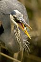
Great blue heron are found on Mount Taylor.
-
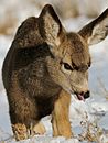
A mule deer fawn in the snow.
-
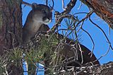
A mountain lion in a tree on Mount Taylor.
-
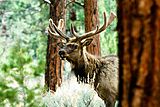
Mount Taylor is home to healthy populations of elk.
-
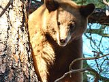
A black bear in a tree on Mount Taylor.
.jpg)


Mining History

The land around Mount Taylor has a lot of a mineral that contains uranium and vanadium. People mined this mineral a lot from 1951 to 1989. Since 1945, hundreds of uranium mines on Pueblo lands have provided over thirteen million tons of uranium ore to the United States.
There have been worries about how future mining might affect this special site. In June 2008, a committee in New Mexico voted to temporarily protect a large area around the mountain. This area, over 422,000 acres, was added to the state's Register of Cultural Properties.
The Navajo Nation, Acoma, Laguna, Zuni pueblos, and the Hopi tribe asked for this protection. They consider Mount Taylor sacred. They wanted to protect it from new uranium mining projects. In April 2009, Mount Taylor was added to the National Trust for Historic Preservation's list of America's Most Endangered Places. This list highlights important places that are at risk.
Past Events
On September 3, 1929, a passenger plane called the City of San Francisco crashed into Mount Taylor. This happened during a thunderstorm. The plane was on a flight from Albuquerque to Los Angeles. All eight people on board died.
On April 7, 1961, a B-52B bomber plane accidentally crashed on Mount Taylor. It was hit by a missile launched from another jet during a practice exercise. Three of the eight crew members on the bomber were killed. An electrical problem caused the missile to launch by mistake.
