
Valles Caldera facts for kids
Quick facts for kids Valles Caldera |
|
|---|---|

Cerro la Jara, an approximately 246 feet (75 m) high forested rhyolite lava dome within the caldera
|
|
| Highest point | |
| Elevation | 11,253 ft (3,430 m) |
| Geography | |

Valles Caldera
Location in New Mexico
|
|
| Location | Sandoval County, New Mexico, US |
| Parent range | Jemez Mountains |
| Geology | |
| Mountain type | Complex Caldera |
| Volcanic arc/belt | Jemez Lineament and Rio Grande Rift |
| Last eruption | 68,900 ± 1,000 years BP |
| Climbing | |
| Easiest route | New Mexico State Road 4 |
| Designated: | 1975 |
| Valles Caldera National Preserve | |
|---|---|
.jpg)
Valles Caldera
|
|
| Location | Sandoval and Rio Arriba counties, New Mexico, United States |
| Nearest city | Los Alamos, New Mexico |
| Area | 89,766 acres (363.27 km2) |
| Established | July 25, 2000 |
| Governing body | National Park Service |
| Website | Valles Caldera National Preserve |
The Valles Caldera (also known as the Jemez Caldera) is a huge volcanic bowl, about 13.7 miles (22 km) wide, located in the Jemez Mountains of northern New Mexico. A caldera is a large, bowl-shaped hollow that forms when the ground above a magma chamber collapses after a volcanic eruption.
This area is full of interesting natural features. You can find hot springs, streams, and even places where natural gas seeps out of the ground. There are also volcanic domes, which are hills formed by slow-moving lava. The highest point inside the caldera is Redondo Peak, a mountain that was pushed up by lava after the caldera formed.
Inside the Valles Caldera, there are several grassy valleys called valles. The biggest one is Valle Grande, and it's the only one you can reach by a paved road. In 1975, the Valles Caldera was named a National Natural Landmark. Most of it is now part of the Valles Caldera National Preserve, which is managed by the National Park Service. This special place has a rich history, important natural resources, and a fascinating geological story.
Contents
History of Valles Caldera
People have used the Valles Caldera for a very long time. Spear points found here show that people lived in the area as far back as 11,000 years ago.
Early Native American Use
Many Native American tribes visited the caldera. They came to hunt the many animals living there. They also collected obsidian, a type of volcanic glass common in this area. Obsidian was used to make tools and weapons. Tribes traded obsidian from the caldera across much of the Southwest.
Later, Spanish and Mexican settlers, along with the Navajo and other tribes, used the caldera seasonally. They brought their livestock to graze on the land. Sometimes, this led to conflicts and raids between different groups.
After the United States took over New Mexico in 1848, the caldera became a place where the U.S. Army fought in the Indian wars. Around the same time, people started using the caldera's forests for ranching and cutting down trees.
The Baca Ranch Era
In 1876, the caldera became part of the Baca Ranch. The Bacas were a wealthy family who received this land. It was given to them as payment for another land grant that was taken away. This large area, about 100,000 acres (40,469 hectares), was called Baca Location number one.
Over the years, the land was bought and sold by different private owners and businesses. A notable owner was Frank Bond in the 1930s. He ran up to 30,000 sheep in the caldera. This was far too many animals for the land, and it caused a lot of damage from which the area is still recovering.
The Dunigan family from Texas bought the land in 1963. They didn't own the rights to the timber at first. So, the New Mexico Lumber Company cut down many old douglas fir and ponderosa pine trees. The Dunigans later bought the timber rights in the 1970s and slowed down the logging. They tried to sell the property to the National Park Service and the US Forest Service in the 1980s, but it didn't work out.

Valles Caldera National Preserve is Created
On July 25, 2000, President Clinton signed the Valles Caldera Preservation Act. This law created the Valles Caldera National Preserve (VCNP). The US government bought the ranch using money from a special fund. This fund comes from fees the government gets from offshore oil and gas drilling.
The Dunigan family sold almost all of their land, about 95,000 acres (38,445 hectares), to the government for $101 million. They also sold most of the rights to the geothermal energy underground.
Some parts of the Baca Ranch are very important to Native American tribes. Because of this, about 5,000 acres (2,023 hectares) were given to the Santa Clara Pueblo. This land includes the start of Santa Clara Creek, which is sacred to the pueblo. Also, 300 acres (121 hectares) on the southwest side were given to Bandelier National Monument.
When the government bought the ranch, it was home to many different plants and animals. It had 40 miles (64 km) of clean trout streams. There were also 66,118 acres (26,757 hectares) of conifer forest. Seventeen endangered plant and animal species lived there. Plus, 25,000 acres (10,117 hectares) of grassland fed New Mexico's largest elk herd, with about 8,000 elk. Other federal lands surround the preserve, like the Santa Fe National Forest and Bandelier National Monument.
The Valles Caldera Preservation Act of 2000 also created the Valles Caldera Trust. This was a new way to manage the land. It tried to combine private business ideas with federal land management rules. The idea was for the preserve to become financially self-sustaining by 2015. However, this experiment was difficult. By 2010, the Trust admitted it couldn't make enough money to manage the property on its own.
Many Environmentalists wanted the preserve to be managed by the National Park Service. They believed this would offer better protection. In 2014, President Obama signed a law that officially transferred the preserve to the National Park Service. The National Park Service took over daily management on October 1, 2015.
The Las Conchas Fire
In July 2011, a large wildfire called the Las Conchas Fire started near the preserve. It burned about 30,000 acres (12,140 hectares) of the Valles Caldera National Preserve. The fire burned a total of 156,000 acres (63,123 hectares) in the Jemez Mountains. This included most of the nearby Bandelier National Monument.
The Jemez Mountains have a dry climate with grasslands and certain trees that are used to wildfires. However, changes in climate and human actions have led to fires that are much hotter and more intense. These types of fires make it harder for the natural environment to recover.
Geoscience of the Caldera


The Valles Caldera is shaped like a circle and is 13.7 miles (22 km) across. Scientists have studied this caldera and the volcanoes around it very closely. They learn about how magma moves, how hot water systems work, and how valuable minerals form here. They have drilled nearly 40 deep holes to gather information about the ground below.
The Valles Caldera is actually the younger of two calderas in this spot. It formed over and covered an older one called the Toledo Caldera. The Toledo and Valles Calderas formed during huge eruptions 1.61 million and 1.25 million years ago. These eruptions created the Bandelier Tuff, a light-colored rock that forms the beautiful mesas (flat-topped hills) of the Pajarito Plateau today.

Valles Caldera is famous for being a "resurgent dome" caldera. This means that after the main eruption, the center of the caldera was pushed up by new magma, forming a dome like Redondo Peak. Scientists first studied this process here in the 1960s. Their work at Valles has helped them understand other resurgent domes around the world, like the one at Yellowstone Caldera.
The most recent eruption at Valles Caldera happened about 68,900 years ago. Even today, there's an active geothermal system with hot springs and fumaroles (vents that release steam and gases). This shows that there's still heat and activity deep underground. The volcanic activity here is linked to the way the Earth's plates are moving in this region.
In the 1960s, NASA used the Valles Caldera to train the Apollo Astronauts. They learned about volcanic features like ash flows and lava domes. This training helped them recognize similar features on the Moon.

Climate in Valles Caldera
The Valles Caldera has a subarctic climate. This means it has cold winters and mild summers. The temperature can change a lot between day and night, especially because cold air often gets trapped in the caldera.
Geothermal Energy Potential
Because Valles Caldera is a volcanic area, it has the potential for geothermal energy. This is a clean energy source that uses heat from inside the Earth. However, some people are against developing geothermal energy here. They worry it might harm the beautiful scenery and affect the hot springs.
Scientists have done experiments in the area to learn about geothermal energy. From 1959 to 1983, about 40 wells were drilled to explore for geothermal energy. Even though they found high temperatures, the geothermal field was too small to be profitable.
Recreation and Fun Activities

Valles Caldera is a great place for outdoor activities. There are more than two dozen official trails for hiking and biking. You can find maps and descriptions of these trails to help you explore.
The preserve also has many miles of old ranch roads and animal trails. Some of these are now used for horse riding. In the past, Valles Caldera was a popular spot for horse endurance races. The large grassy valley, Valle Grande, is also used for ski orienteering, which is like cross-country skiing combined with navigation.
Many activities are open to the public, but some require reservations. The valley floor is high up, more than 8,000 feet (2,438 m) above sea level.
Wildlife and Livestock
The grassy valleys in the caldera look very neat. You won't see many young trees, and older trees don't have branches low to the ground. This is because many elk and cattle eat the lower branches. Also, frequent grass fires kill the lower branches of trees like Engelmann spruce and Ponderosa pine.
The grasslands used to have native perennial grasses that were kept healthy by frequent fires. But then, sheep and cattle started grazing there. Even though there seems to be a lot of grass, it's a limited resource, and it doesn't grow for long each year. The Valles Caldera National Preserve has a program that allows some cattle to graze in the summer. Thousands of elk also graze here in the warmer months and during dry winters.
Other animals that live in the area include Golden Eagles, striped Badgers, and the Gunnison Prairie Dog. The National Park Service says that the elk population in Valles Caldera is the second largest in New Mexico. Hunting is allowed in the National Preserve during certain times of the year and with specific rules.
Images for kids
-
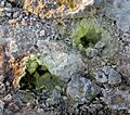
Sulphur fumaroles like these, found in Iceland, are often seen with such volcanic features and are related to the geothermal/geochemistry profile of the magma body.

See also
 In Spanish: Caldera de los Valles para niños
- Jemez Pueblo, New Mexico
- Valle Vidal
