
Jemez Mountains facts for kids
Quick facts for kids Jemez Mountains |
|
|---|---|

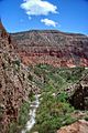
Looking at the Jemez Mountains from Forest Road 376 in Jemez Springs, New Mexico. 2014
|
|
| Highest point | |
| Peak | Chicoma Mountain |
| Elevation | 3,524 m (11,562 ft) NAVD 88 |
| Geography | |

Jemez Mountains
Location in New Mexico
|
|
| State/Province | New Mexico |
| Topo map | USGS Polvadera Peak (1977) |
The Jemez Mountains are a group of mountains in New Mexico, United States. They are found in Rio Arriba, Sandoval, and Los Alamos counties. These mountains are actually a volcanic group, meaning they were formed by volcanoes.
Many Puebloan Indian tribes have lived in the Jemez Mountains area for a very long time. These include the Jemez people, who speak the Towa language. The mountains are named after them. Other groups are the Keres-speaking Keresan Indians and the Tewa-speaking Tewa Indians. In the Tewa language, the Jemez Mountains are called Tsąmpiye'ip'įn.
The highest point in this mountain range is Chicoma Mountain. It stands at about 11,561 feet (3,524 meters) tall. The town of Los Alamos is on the eastern side of the mountains. The Los Alamos National Laboratory is also nearby. On the western side, you'll find the town of Jemez Springs. Pajarito Mountain Ski Area is the only place to ski in the Jemez Mountains. New Mexico State Highway 4 is the main road that helps people get around the area.
Contents
How the Jemez Mountains Formed

The Jemez Mountains are a great example of volcanoes forming far from ocean edges. They are shaped like a big circle around a famous area called the Valles Caldera. A caldera is a large bowl-shaped hollow that forms when the ground collapses after a volcanic eruption.
These mountains sit where two major geological features meet. This area has allowed magma (hot, melted rock) from deep inside the Earth to rise to the surface. This has created a long history of volcanic activity. The first eruptions happened at least 13 million years ago. Volcanic activity continued almost to the present day. The most recent known eruption created a type of volcanic glass called obsidian. This happened about 68,300 years ago.
Most of the mountains are made of older volcanic rocks like basalt and andesite. However, there are also large sheets of rock from huge eruptions. These eruptions formed the Bandelier Tuff and younger rhyolite rocks.
The two biggest caldera-forming eruptions happened about 1.62 million and 1.256 million years ago. These eruptions created huge deposits of rock called ignimbrite. These deposits are now known as the Otowi and Tshirege members of the Bandelier Tuff. Much of this material now forms the Pajarito Plateau. This is a beautiful area with many canyons and mesas. Los Alamos is built on this plateau.
Redondo Peak is the second-highest point in the range. It is 11,254 feet (3,431 meters) tall. This peak is a "resurgent dome" in the middle of the Valles Caldera. A resurgent dome is a mound that forms when the floor of a caldera pushes up after an eruption. The Valles Caldera also has several smaller volcanoes inside it. The caldera's rim and these structures create many lush, grassy valleys. Valles is Spanish for valleys, which is how the caldera got its name.
Things to Do in the Jemez Mountains

A large part of the Jemez Mountains is public land. This includes the Santa Fe National Forest, Bandelier National Monument, and the Valles Caldera National Preserve. There is also Fenton Lake State Park in Sandoval County.
Many hiking trails wind through the mountains and lead to different peaks. Some areas might be closed to hikers. This could be due to rules protecting nature or because the land belongs to the Santa Clara Pueblo or private owners. You can often get a permit to visit Pueblo lands.
The mountain peaks are usually easy to climb in good weather. You don't need special climbing skills. However, rock climbing is popular on some of the basalt cliffs. These are found near Los Alamos and other parts of the range.
The mountains are also home to Pajarito Mountain, a small ski area. You can also go cross-country skiing here. But this depends on whether there is enough snow each winter.
The region can have forest fires. This is because spring weather is often dry and windy. These conditions can make fires spread quickly, whether they are caused by people or lightning. The Las Conchas Fire in 2011 was a very large wildfire. Parts of Los Alamos National Laboratory were damaged, but nothing dangerous was released.
Towns and Communities
The main communities located within the Jemez Mountains are Jemez Springs and Jemez Pueblo.
Wildlife in the Jemez Mountains
The Jemez Mountains are home to many animals. You might see American elk, golden-mantled ground squirrels, and Gunnison's prairie dogs. American beavers, black bears, and mountain lions also live here. The mountains are also home to a very special and rare animal, the Jemez Mountains salamander. This salamander is a federally endangered species.
Images for kids
-
Guadelupita Mesa in the southwestern Jemez
See also
 In Spanish: Sierra de Jémez para niños
