
Bandelier National Monument facts for kids
Quick facts for kids Bandelier National Monument |
|
|---|---|
|
IUCN Category V (Protected Landscape/Seascape)
|
|

Reconstructed kiva at Alcove House
|
|

Bandelier National Monument
Location in New Mexico

Bandelier National Monument
Location in the United States
|
|
| Location | Sandoval, Los Alamos and Santa Fe counties, New Mexico, United States |
| Nearest town | Los Alamos, New Mexico |
| Area | 33,677 acres (136.29 km2) |
| Created | February 11, 1916 |
| Visitors | 210,941 (in 2022) |
| Governing body | National Park Service |
| Website | Bandelier National Monument |
|
Bandelier National Monument
|
|
| Built | 1200 |
| NRHP reference No. | 66000042 (original) 14001017 (increase) |
| Significant dates | |
| Added to NRHP | October 15, 1966 |
| Boundary increase | December 10, 2014 |

Bandelier National Monument is a special place in New Mexico, United States. It covers about 33,677-acre (136 km2) of land. This monument protects the ancient homes and lands of the Ancestral Puebloans. These are people who lived in the Southwest a long time ago. Most of the old buildings you can see here were built between the years 1150 and 1600.
The monument is part of the Pajarito Plateau. This area is on the slopes of the Jemez volcanic field, which is in the Jemez Mountains. More than 70% of Bandelier is a wilderness area. The land changes a lot in height, from about 5,000 feet (1,500 m) near the Rio Grande river to over 10,000 feet (3,000 m) at the top of Cerro Grande. This big change in height means there are many different types of plants and animals.
Bandelier has about 3 miles (5 km) of roads and over 70 miles (110 km) of hiking trails. It protects old Ancestral Pueblo sites and beautiful landscapes. It also has the biggest collection of buildings built by the Civilian Conservation Corps (CCC) in a national park area. The CCC was a group that helped build things during the Great Depression. About two-thirds of the park, 23,267 acres (9,416 ha), is a special wilderness area. In this area, cars and permanent buildings are not allowed.
President Woodrow Wilson created Bandelier as a national monument on February 11, 1916. It was named after Adolph Bandelier. He was a Swiss-American anthropologist who studied the cultures of this area. He also wanted to protect these important sites. Many of the park's buildings were built in the 1930s by the CCC. These buildings are now a National Historic Landmark because they are so well-preserved. The National Park Service works with local Native American Pueblos and other groups to manage the park.
Contents
Exploring Bandelier's Land and Rocks
In October 1976, about 70% of the monument, which is 23,267 acres (9,416 ha), became part of the National Wilderness Preservation System. The park's height ranges from about 5,000 feet (1,500 m) near the Rio Grande to over 10,200 feet (3,100 m) at the top of Cerro Grande. The Valles Caldera National Preserve is next to the monument on the north and west. It stretches into the Jemez Mountains.
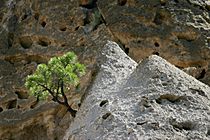
Much of this area is covered with volcanic ash. This ash, called Bandelier Tuff, came from a huge volcano eruption about 1.14 million years ago. The tuff sits on top of older rocks like shale and sandstone from the Permian Period. It also covers limestone from the Pennsylvanian age. The volcanic rock was not all the same hardness. The Ancestral Puebloans used the harder parts as bricks. They carved their homes out of the softer rock.
A Look Back at Bandelier's History
People have lived in this area for over 10,000 years. The first permanent homes built by the ancestors of the Puebloan peoples appeared around 1150 CE. By 1550, these settlers had moved closer to the Rio Grande. We know they traded with other groups, even as far away as Mexico. This is because we find basalt and obsidian tools, rock markings, and similar building styles.
Spanish settlers arrived in the 1700s. In 1880, a Pueblo man named Jose Montoya took Adolph Bandelier to see the area. Bandelier was amazed by the cliff dwellings. He said, "It is the grandest thing I ever saw."
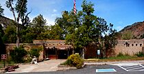
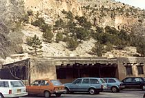
Because of Bandelier's work, people wanted to protect the area. President Woodrow Wilson signed the paper to create the monument in 1916. Buildings like a lodge were built in the 1920s and 1930s. These structures were built by the Civilian Conservation Corps (CCC) during the Great Depression. They are the largest group of CCC-built structures in a national park that haven't been changed much. These 31 buildings show the style of National Park Service Rustic architecture. This style uses local materials and designs. It is now a national landmark district.
During World War II, the monument was closed to visitors for a few years. The lodge was used to house people working on the Manhattan Project. This was a secret project at Los Alamos to build the atomic bomb. In 2019, Senator Martin Heinrich suggested making Bandelier National Monument a national park and preserve.

What You Can See at Bandelier
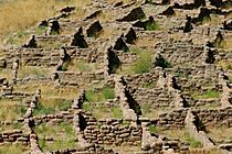
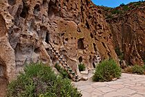
Frijoles Canyon has many ancient pueblo homes. It also has kivas (special ceremonial buildings), rock paintings, and petroglyphs (carvings in rock). Some homes were stone buildings on the canyon floor. Others were cavates, which are small caves carved into the soft volcanic rock of the canyon wall.
A paved trail called the "Main Loop Trail" is about 1.2-mile (1.9 km) long. It starts at the visitor center and lets you see these features. If you keep going past this loop, you can reach Alcove House. This is a natural shelter cave formed by erosion. It has a small, rebuilt kiva that hikers can enter using a ladder.


Ancient Pueblo Homes and Sites
One interesting old site in the canyon is Tyuonyi (pronounced Que-weh-nee) pueblo. Nearby are other building sites like Long House. Tyuonyi is a round pueblo that used to be one to three stories tall. Long House is next to Tyuonyi. It was built along the canyon walls and used them for support. You can also see a rebuilt Talus House along the Main Loop Trail.

These sites date from the Pueblo III Era (1150 to 1350) to the Pueblo IV Era (1350 to 1600). Scientists have figured out when Tyuonyi was built using the tree-ring method. This method works by looking at tree rings in old wood. Pieces of ceiling beams from different rooms show dates between 1383 and 1466. This was a busy time for building in Frijoles Canyon. Other ruins also show building activity in the early and mid-1400s. The last building in Frijoles Canyon was probably around 1500. The most people lived here around that time.
Before Tyuonyi was built, the Ancestral Puebloan people were changing and moving a lot. The time when Frijoles Canyon had the most people was also when many Ancestral Puebloans moved away from the Four Corners area. That area was having a bad drought, environmental problems, and social unrest. Experts believe some groups moved to the Rio Grande valley. They then founded Tyuonyi and other nearby sites. The pueblo was left empty by 1600. The people moved to pueblos near the Rio Grande, like Cochiti and San Ildefonso Pueblos. These pueblos are still lived in today.
Other trails go into the wilder parts of the monument. Here you can find more small old sites, canyons, mesas, and sometimes waterfalls. You can take short hikes or even multi-day backpacking trips. Some of these backcountry sites have been covered by Cochiti Lake. This reservoir on the Rio Grande was made to stop seasonal flooding.
There's also a separate part of the monument called the Tsankawi unit. It's near Los Alamos. It has some old sites that have been dug up and petroglyphs. Tsankawi also has the remains of a home and school for Native Americans. This was started in the late 1800s by Baroness Vera von Blumenthal and her friend Rose Dougan.
In the higher parts of the monument, you can go Nordic skiing on some trails. You can reach these trails from New Mexico Highway 4. But it doesn't snow enough every winter for good skiing.
Animals You Might See at Bandelier
There are many animals here. You often see deer and Abert's squirrels in Frijoles Canyon. Black bear and mountain lions live in the monument. You might see them if you hike in the backcountry. A large group of elk are here in winter. This is when snow forces them down from their summer homes in the Jemez Mountains.
Many bats live in the shelter caves in the canyon walls during certain seasons. You might even see them near the loop trail in Frijoles Canyon. Wild turkeys, vultures, ravens, and several types of birds of prey are common. You can also see many kinds of hummingbirds. Sometimes, you might spot Rattlesnakes, tarantulas, and horned lizards along the trails.
Bandelier Museum: Learning About the Past
The visitor center at Bandelier National Monument has exhibits about the people who lived here long ago. You can see old Pueblo pottery, tools, and things they used every day. Two life-size displays show what Pueblo life was like in the past and how it is today. There are also modern Pueblo pottery pieces. You can see 14 pastel artworks by Works Progress Administration artist Helmut Naumer Sr. There is also wood furniture and metalwork made by the Civilian Conservation Corps during the Depression. A short 10-minute film gives you a quick overview of the monument.
Hiking Trails at Bandelier
The National Park Service has several marked trails. They suggest bringing enough safe water on some trails.
The Pueblo Loop Trail (also called the Main Loop Trail) is about 1.4 miles (2.3 km) long. It goes through important old sites like the Big Kiva, Tyuonyi, Talus House, and Long House. It takes about 45 minutes to an hour to walk. There are some optional ladders you can climb to enter the cavates (small carved alcoves).
Before the modern road was built, the Frey Trail was the only way to get into the canyon. The parking lot used to be at the canyon rim. Today, the trail starts at the campground amphitheater. This trail is 1.5 miles (2.4 km) one way. It goes down about 550 feet (170 m).

The Alcove House trail starts at the west end of the Main Loop trail. It goes for 0.5 miles (800 m) to Alcove House. This place used to be called the Ceremonial Cave. The alcove is about 140 feet (43 m) above the floor of Frijoles Canyon. About 25 Ancestral Pueblo people lived in this pueblo. Except in winter, you can reach the site by climbing four wooden ladders and stone stairs. Alcove House has a rebuilt kiva. You can see holes where viga (wooden beams) were and niches from several homes.
However, since spring 2013, you cannot go inside the kiva itself. This is for safety reasons while they work to make the structure stronger. The ladders and stairs to the alcove are open to the public again.
The Falls Trail begins at the east end of the Backcountry Parking Lot. It is about 2.5 miles (4.0 km) long and goes down 700 feet (200 m). It passes two waterfalls and ends at the Rio Grande. But parts of the trail beyond Upper Frijoles Falls are closed. This is because of damage from the 2011 Las Conchas Fire. It might be closed permanently. Besides the big change in height, the trail has steep drop-offs in many places and no bridges over Frijoles Creek. These challenges are still there on the part of the trail that is open.
The 2.5 miles (4 km) Frijolito Loop Trail is harder. It starts in the Cottonwood Picnic Area and climbs out of Frijoles Canyon using a winding path. Once you are on top of the mesa, you will pass Frijolito Pueblo. It then returns to the visitor center along the Long Trail.
Other backcountry trails go into the wilderness area of the monument. They cross Alamo and Capulin Canyons and connect to the Dome Trailhead in the Santa Fe National Forest. Not many visitors use these trails, so their condition can vary.
Images for kids
- Bandelier
-
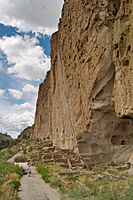
Main cliff on loop trail
-
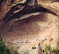
Painted Cave, Ancestral Puebloan pictographs in the Bandelier backcountry
-
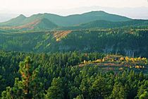
Forested mesa tops are framed by the San Miguel Mountains in the Bandelier Wilderness
-
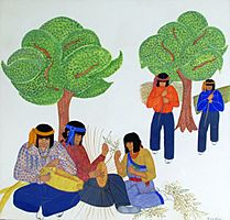
Basketmaking by Pablita Velarde, c. 1940. Bandelier museum collection
-
Visitor Center
-
Park headquarters
-
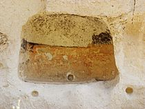
Tyuonyi Pueblo, Detail
-
Tent-Rocks
-
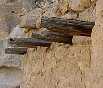
Cliff Dwellings detail, showing stone and wood use, Bandelier National Monument, NM
-
Cliff Dwelling detail, Bandelier National Monument, NM
-
The face of a small cliff showing dwellings and a reconstructed ladder to access them
-
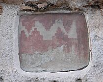
Petrograph in Frijoles Canyon


Bandelier's Special Architecture Style
|
Bandelier CCC Historic District
|
|
.jpg)
Superintendent's Residence, Bandelier CCC Historic District, in 1984
|
|
| Area | 54 acres (22 ha) |
|---|---|
| Built | 1933 |
| Architect | Lyle Bennett; Et al. |
| Architectural style | Pueblo Revival |
| NRHP reference No. | 87001452 |
| Significant dates | |
| Added to NRHP | May 28, 1987 |
| Designated NHLD | May 28, 1987 |
Bandelier has great examples of buildings made in the National Park Service Rustic style. These were built by the Civilian Conservation Corps (CCC) during the Great Depression. The CCC camp at Bandelier employed thousands of men from 1933 to 1941. They built roads, trails, and park buildings. In 1943, the camp was used to house scientists and their families. They were working on the secret Manhattan Project at nearby Los Alamos. Construction workers also stayed there in early 1944.
The park's main area was designed to look like a traditional Pueblo village. Most of the CCC-built buildings are around a wooded plaza. They were made to house park staff and provide services for visitors. They also included areas for maintenance. These historic buildings include the Frey Lodge (park headquarters), guest cabins (now employee housing), the gift shop, and the park visitor center. The CCC crews also made furniture for these buildings. Artists, paid by a government program, created artwork. These well-preserved CCC buildings were named a National Historic Landmark in 1987.
