Santa Fe County, New Mexico facts for kids
Quick facts for kids
Santa Fe County
|
|||
|---|---|---|---|
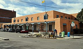
Original Santa Fe County Courthouse
|
|||
|
|||
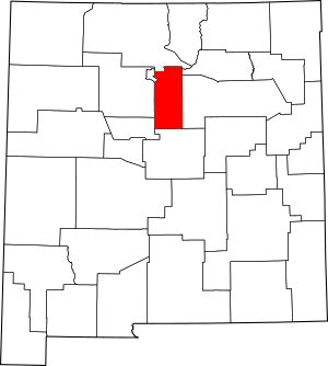
Location within the U.S. state of New Mexico
|
|||
 New Mexico's location within the U.S. |
|||
| Country | |||
| State | |||
| Founded | 1852 | ||
| Seat | Santa Fe | ||
| Largest city | Santa Fe | ||
| Area | |||
| • Total | 1,911 sq mi (4,950 km2) | ||
| • Land | 1,909 sq mi (4,940 km2) | ||
| • Water | 1.5 sq mi (4 km2) 0.08%% | ||
| Population
(2020)
|
|||
| • Total | 154,823 | ||
| • Density | 81.017/sq mi (31.281/km2) | ||
| Time zone | UTC−7 (Mountain) | ||
| • Summer (DST) | UTC−6 (MDT) | ||
| Congressional districts | 1st, 3rd | ||
Santa Fe County (which means Holy faith in Spanish) is a county located in the state of New Mexico. In 2020, about 154,823 people lived here. This makes it New Mexico's third-most populated county. Its main city, Santa Fe, is also the state capital.
Santa Fe County is part of a larger area called the Santa Fe metropolitan statistical area. This area is also included in the Albuquerque–Santa Fe–Las Vegas combined statistical area.
Contents
Geography of Santa Fe County
Santa Fe County covers about 1,911 square miles (4,949 square kilometers). Most of this area is land, with only a small part being water. It is the fifth-smallest county in New Mexico by size.
The highest point in the county is the top of Santa Fe Baldy. This mountain is about 3,847 meters (12,621 feet) tall. The county's land is watered by the Rio Grande river and many smaller streams that flow into it.
Neighboring Counties
Santa Fe County shares borders with several other counties:
- Rio Arriba County to the north
- Mora County to the northeast
- San Miguel County to the east
- Torrance County to the south
- Bernalillo County to the southwest
- Sandoval County to the west
- Los Alamos County to the northwest
Protected Natural Areas
Parts of these important national areas are found in Santa Fe County:
- El Camino Real de Tierra Adentro National Historic Trail
- Pecos National Historical Park
- Santa Fe National Forest
Population and People
| Historical population | |||
|---|---|---|---|
| Census | Pop. | %± | |
| 1850 | 7,713 | — | |
| 1860 | 8,114 | 5.2% | |
| 1870 | 9,699 | 19.5% | |
| 1880 | 10,867 | 12.0% | |
| 1890 | 13,562 | 24.8% | |
| 1900 | 14,658 | 8.1% | |
| 1910 | 14,770 | 0.8% | |
| 1920 | 15,030 | 1.8% | |
| 1930 | 19,567 | 30.2% | |
| 1940 | 30,826 | 57.5% | |
| 1950 | 38,153 | 23.8% | |
| 1960 | 44,970 | 17.9% | |
| 1970 | 53,756 | 19.5% | |
| 1980 | 75,360 | 40.2% | |
| 1990 | 98,928 | 31.3% | |
| 2000 | 129,292 | 30.7% | |
| 2010 | 144,170 | 11.5% | |
| 2020 | 154,823 | 7.4% | |
| U.S. Decennial Census 1790-1960 1900-1990 1990-2000 2010 |
|||
2010 Census Information
In 2010, there were 144,170 people living in Santa Fe County. There were 61,963 households, which are groups of people living together. The population density was about 75.5 people per square mile.
Most people (67.2%) identified as white. About 50.6% of the population said they were of Hispanic or Latino background.
The largest ancestry groups included:
- Mexican (22.4%)
- German (11.2%)
- Spanish (11.1%)
- English (10.0%)
- Irish (8.4%)
- French (3.6%)
- Italian (3.2%)
- Scottish (2.5%)
- American (2.3%)
- Scotch-Irish (2.1%)
- Polish (1.8%)
- Swedish (1.3%)
- Russian (1.3%)
- Dutch (1.2%)
- Norwegian (1.1%)
About 26.9% of households had children under 18 living with them. The average household had 2.28 people. The average age of people in the county was 43.0 years old.
The median income for a household was $52,696 per year. For families, the median income was $64,041 per year. About 14.4% of the population lived below the poverty line. This included 21.4% of those under 18.
Education in Santa Fe County
There are four main public school districts in Santa Fe County:
- Española Public Schools
- Moriarty Municipal Schools
- Pojoaque Valley Public Schools
- Santa Fe Public Schools
There is also a state-run school:
- New Mexico School for the Deaf
Some schools are connected with the Bureau of Indian Education (BIE):
- Santa Fe Indian School (run by tribes)
- San Ildefonso Day School (run by BIE) - located in San Ildefonso Pueblo
- Te Tsu Geh Oweenge Day School (also called Tesuque Day School, run by tribes) - located in Tesuque Pueblo
Communities in Santa Fe County
Cities
Town
Census-Designated Places (CDPs)
These are areas that are like towns but are not officially incorporated as cities or towns.
- Agua Fria
- Arroyo Hondo
- Barton (part)
- Cañada de los Alamos
- Cañoncito
- Cedar Grove
- Chimayo (part)
- Chupadero
- Conejo
- Cuartelez
- Cundiyo
- Cuyamungue
- Cuyamungue Grant
- El Rancho
- El Valle de Arroyo Seco
- Eldorado at Santa Fe
- Encantado
- Galisteo
- Glorieta
- Golden
- Hyde Park
- Jacona
- Jaconita
- La Bajada
- La Cienega
- La Cueva
- La Puebla
- La Tierra
- Lamy
- Las Campanas
- Los Cerrillos
- Madrid
- Nambe
- Peak Place
- Pojoaque
- Rio Chiquito (part)
- Rio en Medio
- San Ildefonso Pueblo
- San Pedro
- Santa Cruz
- Santa Fe Foothills
- Seton Village
- Sombrillo
- Stanley
- Sunlit Hills
- Tano Road
- Tesuque
- Tesuque Pueblo
- Thunder Mountain
- Tres Arroyos
- Valencia
- Valle Vista
Other Communities (Unincorporated)
These are small communities that are not officially part of a city or town.
- Totavi
- Waldo
See also
 In Spanish: Condado de Santa Fe para niños
 | Mary Eliza Mahoney |
 | Susie King Taylor |
 | Ida Gray |
 | Eliza Ann Grier |


