Cañada de los Alamos, New Mexico facts for kids
Quick facts for kids
Cañada de los Alamos, New Mexico
|
|
|---|---|

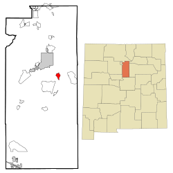
Location of Cañada de los Alamos, New Mexico
|
|
| Country | |
| State | |
| County | Santa Fe |
| Area | |
| • Total | 3.68 sq mi (9.53 km2) |
| • Land | 3.68 sq mi (9.53 km2) |
| • Water | 0.00 sq mi (0.00 km2) |
| Elevation | 7,523 ft (2,293 m) |
| Population
(2020)
|
|
| • Total | 421 |
| • Density | 114.43/sq mi (44.18/km2) |
| Time zone | UTC-7 (Mountain (MST)) |
| • Summer (DST) | UTC-6 (MDT) |
| ZIP code |
87501
|
| Area code(s) | 505 |
| FIPS code | 35-10470 |
| GNIS feature ID | 2407951 |
Cañada de los Alamos is a small community in Santa Fe County, New Mexico, United States. It is part of the larger Santa Fe, New Mexico area. In 2020, about 421 people lived there.
Geography
Cañada de los Alamos covers about 3.7 square miles (9.5 square kilometers) of land. It does not have any water areas.
People Living in Cañada de los Alamos
| Historical population | |||
|---|---|---|---|
| Census | Pop. | %± | |
| 2020 | 421 | — | |
| U.S. Decennial Census | |||
In 2000, there were 358 people living in Cañada de los Alamos. The community had 153 households. Many different groups of people lived there. About 45% of the population was of Hispanic or Latino background.
The average household had about 2 to 3 people. About 31% of households had children under 18. The population included people of all ages. About 25% were under 18 years old. About 36% were between 45 and 64 years old.
Education
Students in Cañada de los Alamos attend schools in the Santa Fe Public Schools district.
See also
 In Spanish: Cañada de los Álamos para niños
 | Misty Copeland |
 | Raven Wilkinson |
 | Debra Austin |
 | Aesha Ash |


