Torrance County, New Mexico facts for kids
Quick facts for kids
Torrance County
|
|||
|---|---|---|---|

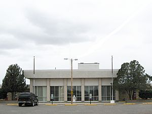
Torrance County Courthouse in Estancia
|
|||
|
|||

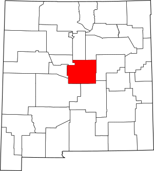
Location within the U.S. state of New Mexico
|
|||
 New Mexico's location within the U.S. |
|||
| Country | |||
| State | |||
| Founded | March 16, 1903 | ||
| Seat | Estancia | ||
| Largest city | Moriarty | ||
| Area | |||
| • Total | 3,346 sq mi (8,670 km2) | ||
| • Land | 3,345 sq mi (8,660 km2) | ||
| • Water | 0.9 sq mi (2 km2) 0.03%% | ||
| Population
(2020)
|
|||
| • Total | 15,045 | ||
| • Density | 4.4964/sq mi (1.7361/km2) | ||
| Time zone | UTC−7 (Mountain) | ||
| • Summer (DST) | UTC−6 (MDT) | ||
| Congressional district | 1st | ||
Torrance County is a county located right in the middle of New Mexico, a state in the United States. As of the 2020 census, about 15,045 people live there. The main town, or county seat, where the county government is located, is Estancia.
This county is special because it's home to the exact geographic center of New Mexico! This spot is southwest of the village of Willard. In 2010, the center of where most people live in New Mexico was also found in Torrance County, near Manzano. Torrance County is part of the larger Albuquerque area.
Contents
Geography: Where is Torrance County?
Torrance County covers a total area of about 3,346 square miles (8,670 km2). Only a tiny part of this, about 0.9 square miles (2.3 km2), is water. Most of the county has gently rolling grasslands. These areas are usually between 6,000 and 6,200 feet high.
The Manzano Mountains are on the western side of the county. They are the only really tall parts of the land, reaching up to 10,098 feet! The highest parts of these mountains are protected in the Manzano Wilderness area. Another interesting natural feature is a group of dry lakebeds and seasonal lakes. These are called playas and are found southeast of Estancia, especially around Laguna del Perro.
Neighboring Counties
Torrance County shares its borders with several other counties:
- Santa Fe County to the north
- San Miguel County to the north
- Guadalupe County to the east
- Lincoln County to the south
- Socorro County to the south
- Valencia County to the west
- Bernalillo County to the northwest
Protected Natural Areas
Parts of these special national areas are found in Torrance County:
- Cibola National Forest
- Salinas Pueblo Missions National Monument
Population: Who Lives Here?
| Historical population | |||
|---|---|---|---|
| Census | Pop. | %± | |
| 1910 | 10,119 | — | |
| 1920 | 9,731 | −3.8% | |
| 1930 | 9,269 | −4.7% | |
| 1940 | 11,026 | 19.0% | |
| 1950 | 8,012 | −27.3% | |
| 1960 | 6,497 | −18.9% | |
| 1970 | 5,290 | −18.6% | |
| 1980 | 7,491 | 41.6% | |
| 1990 | 10,285 | 37.3% | |
| 2000 | 16,911 | 64.4% | |
| 2010 | 16,383 | −3.1% | |
| 2020 | 15,045 | −8.2% | |
| U.S. Decennial Census 1790-1960 1900-1990 1990-2000 2010 |
|||
In 2010, there were 16,383 people living in Torrance County. The population density was about 4.9 inhabitants per square mile (1.9/km2). This means there were about 5 people for every square mile. The county has a mix of different backgrounds, with many people of Hispanic or Latino origin. The average age of people living here was about 41.6 years old.
Communities: Towns and Villages
Torrance County has several towns and villages where people live.
Cities
Towns
- Estancia (This is the county seat!)
- Mountainair
Villages
Census-Designated Places
These are areas that are like towns but are not officially incorporated as cities or villages:
- Deer Canyon
- Duran
- Indian Hills
- Manzano
- Manzano Springs (part)
- McIntosh
- Punta de Agua
- Tajique
- Torreon
Unincorporated Communities
These are smaller areas that are not officially part of a town or village:
Education: Schools in the County
Students in Torrance County attend schools in several different school districts:
- Corona Municipal Schools
- Estancia Municipal Schools
- Moriarty Municipal Schools
- Mountainair Public Schools
- Vaughn Municipal Schools
See also
 In Spanish: Condado de Torrance para niños
 | Dorothy Vaughan |
 | Charles Henry Turner |
 | Hildrus Poindexter |
 | Henry Cecil McBay |


