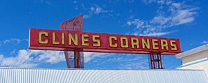
Clines Corners, New Mexico facts for kids
Quick facts for kids
Clines Corners, New Mexico
|
|
|---|---|
 |
|
| Country | United States |
| State | New Mexico |
| County | Torrance |
| Elevation | 7,057 ft (2,151 m) |
| Time zone | UTC-7 (Mountain (MST)) |
| • Summer (DST) | UTC-6 (MDT) |
| ZIP code |
87070
|
| Area code(s) | 575 |
| GNIS feature ID | 898646 |
Clines Corners is a small, unincorporated community located in Torrance County, New Mexico, in the United States. An unincorporated community means it's a place with a shared identity but without its own local government. It's mostly known as a popular stop for travelers.
Clines Corners is found at a very important crossroads. It sits right where Interstate 40 and U.S. Route 285 meet. This spot is about 21.6 miles (34.8 km) east of a town called Moriarty.
History of Clines Corners
How it Started
Clines Corners was created in 1934 by a man named Roy E. Cline. He had a great idea to build a rest stop for people traveling. This rest stop was built at what was then the intersection of the famous U.S. Route 66 and U.S. Route 285.
The Famous Route 66
Route 66 was one of America's first major highways. It connected Chicago to Los Angeles. Many people traveled this road for vacations or to move to new places. Roy E. Cline's rest stop became a vital place for these travelers to take a break.
Clines Corners Today
The original rest stop, now called the Clines Corners Retail Center, has grown a lot. It is now over 30,000 square feet in size. Today, it continues to be a very busy stop for drivers on Interstate 40. This highway has replaced much of the old Route 66. Travelers can find gas, food, and souvenirs there.
 | Percy Lavon Julian |
 | Katherine Johnson |
 | George Washington Carver |
 | Annie Easley |


